
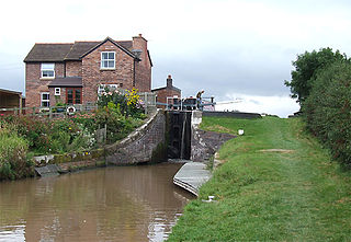
Nantwich Aqueduct is a navigable aqueduct in Acton in Cheshire, England, which carries the Shropshire Union Canal over the Chester to Nantwich road. Designed by Thomas Telford, it dates from around 1826 and is listed at grade II*. [1] [2]
Nantwich Aqueduct is a navigable aqueduct in Acton in Cheshire, England, which carries the Shropshire Union Canal over the Chester to Nantwich road. Designed by Thomas Telford, it dates from around 1826 and is listed at grade II*. [1] [2]
Nantwich Aqueduct was constructed in around 1826, with Thomas Telford as the consulting engineer. [1] [2] Telford designed several aqueducts on the Shropshire Union and other canals using cast iron troughs. [3] The Nantwich example is one of three by Telford with a similar design; the others are at Congleton, also in Cheshire, and Stretton in Staffordshire. [4]
Restoration work was carried out in 2015. The project won the restoration and historic environment category of the Canal & River Trust's Living Waterways Awards in 2016. [5] [6]

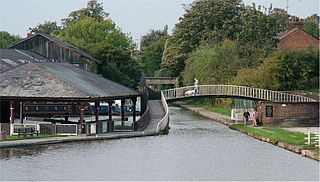
Nantwich Aqueduct is located at SJ6420352578 in the civil parish of Acton, 0.5 miles south east of the village of Acton, and on the edge of the town of Nantwich. It carries the main line of the Shropshire Union Canal (formerly the Birmingham and Liverpool Junction Canal [7] ) over the Chester to Nantwich A534 road. [1] [2] It is listed at grade II*, [1] a grade which recognises "particularly important buildings of more than special interest". [8]
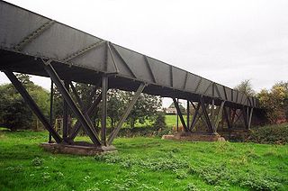
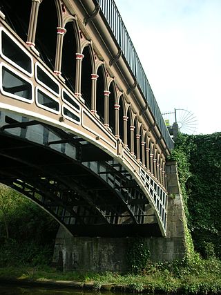
The aqueduct has a single cast-iron arch, with a ribbed underside. The arch spans 29 feet 6 inches and has a maximum height above the road of 15 feet 6 inches. The cast-iron water trough is 13 feet wide, and is flanked on each side by 4 feet wide tow paths, which are paved in red brick. On each side of the bridge, at the level of the water trough, there are five square bolted panels. The arch stretches between stone-dressed brick abutments, which feature pilasters. These stand adjacent to curved brick walls with a stone coping, which retain the embankment. The structure is topped on each side by cast-iron balustrades, 3 feet 9 inch high, which continue along the curved embankment walls. [1] [2] [4]

The River Weaver is a river, navigable in its lower reaches, running in a curving route anti-clockwise across west Cheshire, northern England. Improvements to the river to make it navigable were authorised in 1720 and the work, which included eleven locks, was completed in 1732. An unusual clause in the enabling Act of Parliament stipulated that profits should be given to the County of Cheshire for the improvement of roads and bridges, but the navigation was not initially profitable, and it was 1775 before the first payments were made. Trade continued to rise, and by 1845, over £500,000 had been given to the county.

The Llangollen Canal is a navigable canal crossing the border between England and Wales. The waterway links Llangollen in Denbighshire, north Wales, with Hurleston in south Cheshire, via the town of Ellesmere, Shropshire. The name, which was coined in the 1980s, is a modern designation for parts of the historic Ellesmere Canal and the Llangollen navigable feeder, both of which became part of the Shropshire Union Canals in 1846.

The Pontcysyllte Aqueduct is a navigable aqueduct that carries the Llangollen Canal across the River Dee in the Vale of Llangollen in northeast Wales.

The Shropshire Union Canal, nicknamed the "Shroppie", is a navigable canal in England. The Llangollen and Montgomery canals are the modern names of branches of the Shropshire Union (SU) system and lie partially in Wales.
The Chester Canal was an English canal linking the south Cheshire town of Nantwich with the River Dee at Chester. It was intended to link Chester to Middlewich, with a branch to Nantwich, but the Trent and Mersey Canal were unco-operative about a junction at Middlewich, and so the route to Nantwich was opened in 1779. There were also difficulties negotiating with the River Dee Company, and with no possibility of through traffic, the canal was uneconomic. Part of it was closed in 1787, when Beeston staircase locks collapsed, and there was no money to fund repairs. When the Ellesmere Canal was proposed in 1790, the company saw it as a ray of hope, and somehow managed to keep the struggling canal open. The Ellesmere Canal provided a link to the River Mersey at Ellesmere Port from 1797, and the fortunes of the Chester Canal began to improve.

Chirk Aqueduct is a 70-foot (21 m) high and 710-foot (220 m) long navigable aqueduct that carries what is now the Llangollen Canal across the Ceiriog Valley near Chirk, on the England-Wales border, spanning the two countries.

Marple Aqueduct at Marple, Greater Manchester, in north-west England was built to carry the lower level of the Peak Forest Canal across the River Goyt.
The Shrewsbury Canal was a canal in Shropshire, England. Authorised in 1793, the main line from Trench to Shrewsbury was fully open by 1797, but it remained isolated from the rest of the canal network until 1835, when the Birmingham and Liverpool Junction Canal built the Newport Branch from Norbury Junction to a new junction with the Shrewsbury Canal at Wappenshall. After ownership passed to a series of railway companies, the canal was officially abandoned in 1944; many sections have disappeared, though some bridges and other structures can still be found. There is an active campaign to preserve the remnants of the canal and to restore the Norbury to Shrewsbury line to navigation.

Acton is a small village and former civil parish, now in the parish of Burland and Acton, lying immediately west of the town of Nantwich, in the unitary authority area of Cheshire East and the ceremonial county of Cheshire, England. The civil parish covered 762 acres (3.08 km2) and also included the small settlement of Dorfold and part of Burford, with an estimated population of 340 in 2006. It is administered jointly with the adjacent civil parishes of Henhull and Edleston. Historically, Acton refers to a township and also to an ancient parish in the Nantwich Hundred covering a wide area to the west of Nantwich. The area is agricultural, with dairy farming the main industry. Around a third of the area falls within the Dorfold Estate. Historically, agriculture was the major employer, but it has now been overtaken by the service industries, with many residents commuting significant distances outside the parish to work.

Edstone Aqueduct is one of three aqueducts on a 4 miles (6 km) length of the Stratford-upon-Avon Canal in Warwickshire. At 475 feet (145 m), Edstone is the longest cast iron aqueduct in England. It crosses a minor road, a stream, and a field, a railway line and the trackbed of the disused Alcester branch line. There was once a pipe from the side of the canal that enabled steam locomotives to draw water to fill their tanks.

Cosgrove aqueduct is a navigable cast iron trough navigable aqueduct that carries the Grand Union Canal over the River Great Ouse, on the borders between Buckinghamshire and Northamptonshire at the northwest margin of Milton Keynes in England. The present structure was built in 1811, to replace a previous brick structure that had failed. When the present structure was erected, it was known as the "Iron Trunk". The structure has two cast iron trough spans, with a single central masonry pier. The abutments were constructed in masonry but have been refaced in brick during the twentieth century. The trough is 15 feet (4.6 m) wide, 6 ft 6 in (1.98 m) deep, with a total length of 101 feet (31 m). The canal surface is about 40 feet (12 m) above the surface of the river. There are large approach earthworks about 36 feet (11 m) high above the valley floor and 150 feet (46 m) wide, with a total length of half a mile (800m).
The Engine Arm Aqueduct near Smethwick, West Midlands, England, was built in 1825 by Thomas Telford to carry a water feeder, the Engine Arm, from Edgbaston Reservoir over the BCN New Main Line canal to the adjacent and parallel Old Main Line. The structure is maintained by the Canal & River Trust. It is a Scheduled Ancient Monument and is Grade II* listed.

Minshull Vernon is a hamlet and civil parish in the unitary authority of Cheshire East and the ceremonial county of Cheshire, England. The hamlet lies 3 miles (5 km) to the north west of Crewe, south east of Winsford and south west of Middlewich. The parish also includes the small settlements of Bradfield Green, Eardswick, Hoolgrave, Minshull Hill, Walley's Green and Weaver Bank. The total population of the civil parish is somewhat over 200, measured at 391 in the Census 2011. Nearby villages include Church Minshull, Warmingham and Wimboldsley.
Edleston is a former civil parish, now in the parishes of Burland and Acton and Nantwich, in the unitary authority area of Cheshire East and the ceremonial county of Cheshire, England, which lies immediately to the south west of Nantwich. For administrative purposes, it was combined with adjacent civil parishes of Acton and Henhull to form a total area of 765 hectares. The parish was predominantly rural with scattered farms and houses, with the exception of a new housing estate at the eastern end of the parish east of the canal. Nearby villages include Acton and Ravensmoor.

The Four Counties Ring is a canal ring which links the four English counties of Cheshire, Staffordshire, Shropshire and West Midlands.
The Middlewich Branch of the Shropshire Union Canal is located in Cheshire, in the north west of England, and runs between Middlewich, where it joins the Trent and Mersey Canal, and Barbridge Junction, where it joins the main line of the Shropshire Union Canal. It is 10 miles (16 km) long, and was planned as part of the Chester Canal, which was authorised in 1772, but the company ran out of money, and construction did not begin until 1827. The Trent and Mersey insisted that there should be no direct connection at Middlewich, and instead built the short Wardle Canal to join the two, charging large compensation tolls for traffic passing along it.

The Almond Aqueduct, also known as the Lin's Mill Aqueduct, is a navigable aqueduct that carries the Union Canal over the River Almond in Scotland, west of Ratho, Edinburgh.
The Avon Aqueduct is a navigable aqueduct that carries the Union Canal over the River Avon, near Linlithgow, Scotland.

Stretton Aqueduct is a short cast iron canal aqueduct between Stretton and Brewood, and near to Belvide Reservoir, in south Staffordshire, England. Designed by Thomas Telford and bearing his name plus its date of construction, 1832, it carries the Shropshire Union Canal 30 feet (9.1 m) over the A5 road at a skewed angle.

The Longdon-on-Tern Aqueduct, near Longdon-on-Tern in Shropshire, was one of the first two canal aqueducts to be built from cast iron.