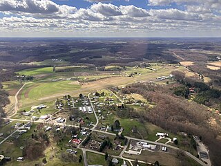
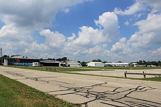
Harbor Springs Municipal Airport, also known as Harbor Springs Airport, is a public airport located three miles (5 km) east of the central business district of Harbor Springs, a city in Emmet County, Michigan, United States. It is included in the Federal Aviation Administration (FAA) National Plan of Integrated Airport Systems for 2017–2021, in which it is categorized as a local general aviation facility.
Greater Kankakee Airport is a public use airport located three nautical miles (6 km) south of the central business district of Kankakee, a city in Kankakee County, Illinois, United States. It is included in the National Plan of Integrated Airport Systems for 2011–2015, which categorized it as a general aviation facility.
Eagles Nest Airport is a privately owned public-use airport serving general aviation aircraft. It was upgraded in April 1989, but had been in operation since the 1960s. It is located two nautical miles north of the community of West Creek, in Eagleswood Township, New Jersey.
Poplar Grove Airport is a small general aviation airport located in Poplar Grove, Illinois, United States. The airport was founded in 1972 as Belvidere Airport and renamed in 1994. It is located 3 miles south of Poplar Grove, and 3 miles north of Belvidere. The airport is privately owned and open to the public.
Newark–Heath Airport is a public airport located in Heath, Ohio. It is three miles (4.8 km) southwest of the central business district of Newark, a city in Licking County, Ohio, United States. The airport was opened in 1930 by the city of Newark, and was transferred to the Licking County Regional Airport Authority in 1967. The airport currently has a McDonnell Douglas F-4C Phantom II S.N. 64–0683 on static display.

Union County Airport is a public use airport in Union County, Ohio, United States. It is owned by the Union County Airport Authority and located one nautical mile (2 km) southeast of the central business district of Marysville, Ohio. This airport is included in the National Plan of Integrated Airport Systems for 2011–2015, which categorized it as a general aviation facility.
Van Wagnen Airport is a privately owned, public use airport located five nautical miles west of the central business district of Napoleon, a community in Napoleon Township, Jackson County, Michigan, United States. It was formerly known as Day Field, owned by Janet Day.
Paul C. Miller–Sparta Airport is a public airport located 3 mi (5 km) southeast of Sparta, Michigan. Established in 1941, the airport is currently owned and operated by the Village of Sparta and is self-supporting, requiring no public funding. It is included in the Federal Aviation Administration (FAA) National Plan of Integrated Airport Systems for 2017–2021, in which it is categorized as a regional general aviation facility.

Carroll County–Tolson Airport is a county–owned, public-use airport located one nautical mile (1.85 km) southeast of the central business district of Carrollton, a village in Carroll County, Ohio, United States. It is owned by the Carroll County Airport Authority. According to the FAA's National Plan of Integrated Airport Systems for 2009–2013, it is categorized as a general aviation airport.

Meyers–Diver's Airport is located in Tecumseh, Michigan, United States. It is at an elevation of 815 feet. It is owned by Al Meyers Airport, Inc. and managed by Andy Alto.

Luce County Airport is a county-owned public-use airport located three miles southeast of the central business district of Newberry, a city in Luce County, Michigan, United States. It is included in the Federal Aviation Administration (FAA) National Plan of Integrated Airport Systems for 2017–2021, in which it is categorized as a basic general aviation facility.
Dalton Airport is a privately owned, public use airport located two nautical miles (4 km) east of the central business district of Flushing, in Genesee County, Michigan, United States. It is named after its founder, Edwin P. Dalton, who opened it in 1946 on the former site of the Marsa farm.
Three Rivers Municipal Dr. Haines Airport is a public-use airport located two miles northeast of Three Rivers, Michigan. The aircraft is publicly owned by the city. The airport covers 305 acres.
Andrews University Airpark is a privately owned, public use airport located 2 miles west of Berrien Springs, Michigan. It is owned and managed by Andrews University, a Seventh Day Adventist university that manages an aviation department.
Maple Grove Airport is a privately owned, public-use airport located 3 miles north of Fowlerville, Michigan. The airport is on an elevation of 906 ft.
The Torchport Airport, also known as the Torchport Airpark, is a privately owned, public use airport located 3 miles south of Eastport, Michigan. It is at an elevation of 640 ft. The airport is located on Torch Lake between Charlevoix and Traverse City.
Ray Community Airport is a privately owned, public use airport located in Ray Township, Macomb County. Michigan. The airport sits on 93 acres of land at an elevation of 632 feet.
Marine City Airport is a privately owned, public use airport located 4 miles west of Marine City in St. Clair County, Michigan.
Mecosta Morton Airport is a publicly owned, public use airport located 2 miles west of Mecosta in Mecosta County, Michigan. The airport sits on 12 acres at an elevation of 1022 feet.
Weltzien Skypark is a privately owned, public use airport located 3 miles west of Wadsworth, Ohio, in Medina County. The airpark sits on 26 acres at an elevation of 1210 feet.


