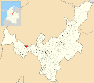
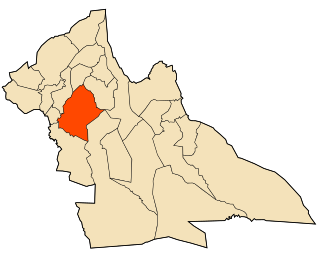
Tununguá is a town and municipality in Boyacá Department, Colombia, part of the subregion of the Western Boyacá Province. Tununguá is situated in the Eastern Ranges of the Colombian Andes at a relatively low altitude of 1,246 metres (4,088 ft). The municipality borders the department of Santander in the north and east and the Boyacá municipalities Pauna and Briceño (south).
Babine Mountains Provincial Park is a provincial park in British Columbia, Canada, located to the east of the Bulkley River between the town of Smithers and Babine Lake. Established by Order-in-Council as the Babine Mountains Recreation Area in 1984, it was upgraded to park status and its name changed in 1999. It contains approximately 31,465 hectares.

Gyügye is a small village in Szabolcs-Szatmár-Bereg county, in the Northern Great Plain region of eastern Hungary.
Kot Najeebullah, also Spelled Kot Najibullah, is one of the 44 union councils, administrative subdivisions, of Haripur District.

Marjaliza is a municipality located in the province of Toledo, Castile-La Mancha, Spain. According to the 2006 census (INE), the municipality has a population of 302.

San Esteban del Molar is a municipality located in the province of Zamora, Castile and León, Spain. According to the 2004 census (INE), the municipality has a population of 168 inhabitants.
Santa María de Valverde is a municipality located in the province of Zamora, Castile and León, Spain. According to the 2004 census (INE), the municipality has a population of 95 inhabitants.

Havelian Tehsil is an administrative subdivision (tehsil) of Abbottabad District in the Khyber Pakhtunkhwa province of Pakistan.

The Tarnak River is located in Ghazni, Zabul, and Kandahar provinces of Afghanistan. The city of Kandahar is located on a plain directly adjacent to the Tarnak.
Daud Khel, is a town of Mianwali District, Punjab, Pakistan.
Deurali is a Village Development Committee in Gorkha District in the Gandaki Zone of northern-central Nepal. At the time of the 1991 Nepal census it had a population of 4,800 and had 984 houses in the town.
Quang Châu is a ward in Việt Yên, Bắc Giang Province, in northeastern Vietnam.

Ourtzagh is a town in Taounate Province, Taza-Al Hoceima-Taounate, Morocco. According to the 2004 census, it has a population of 15,216.
Ain Taoujdate is a city in El Hajeb Province, Fès-Meknès, Morocco. It is located roughly halfway between the cities of Fez and Meknes and is serviced by the national ONCF train line. According to the 2004 census, it had a population of 22,030.
El Ghicha District is a district of Laghouat Province, Algeria.

El Ghicha is a town and commune in Laghouat Province, Algeria. According to the 1998 census, it has a population of 5,719.

The Stone Bridge or Silifke Bridge is a historical bridge in Mersin Province, Turkey.
Oued Jdida is a small town and rural commune in Meknès-El Menzeh Prefecture of the Fès-Meknès region of Morocco. At the time of the 2004 census, the commune had a total population of 13634 people living in 2309 households.
Operation Virginia Ridge was a US Marine Corps operation that took place in northwest Quảng Trị Province, South Vietnam, from 2 May to 16 July 1969.

The Mirpur Division is a first-order administrative division of the Pakistani dependent territory of Azad Kashmir. Mirpur is the largest division by population in Azad Kashmir. It comprises the portion of the former Mirpur District of the princely state of Jammu and Kashmir that came under Pakistani control at the end of the Indo-Pakistani War of 1947.
This page is based on this
Wikipedia article Text is available under the
CC BY-SA 4.0 license; additional terms may apply.
Images, videos and audio are available under their respective licenses.
