This article has multiple issues. Please help improve it or discuss these issues on the talk page . (Learn how and when to remove these messages)
|
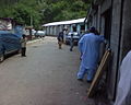
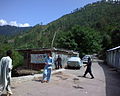
Bhalgran is a village in Poonch District in Azad Kashmir.
This article has multiple issues. Please help improve it or discuss these issues on the talk page . (Learn how and when to remove these messages)
|
Bhalgran is a village in Poonch District in Azad Kashmir.
Bhalgran is located an hours drive from the capital of Poonch district, the city of Rawalakot.

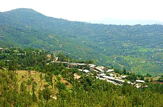
Village of Thorar is in the east of Bhalgran, while the Jhelum River is located in the west of Bhalgran. It is a beautiful region of this part of Jammu & Kashmir, its sub-parts contain the villages of Sardi, Lway, Dubyern, Rarotha, Chetti Trar, Numb Dumbnota and Hill Koliary.

It is located 75 kilometres (47 mi) from Kohala. Bhalgran is connected with Rawalpindi and Islamabad via the neighbouring districts of Azad Pattan and Dhalkot, and with Muzaffarabad through Kohalla. Majority of the population in Bhalgran belong to the Sudhun Tribe.
Literacy rate of Bhalgran is 85%
People of this region mostly play volleyball, cricket and Tash(Cards).
The town has few good bazaars where all essential commodities of life are easily available.

There is a large diaspora of people from Bhalgran in the Middle East and Europe, as employment opportunities for the population are non-existent, some find employment with the Military or in government departments. The area has subsistence level of farming which is not enough to feed a family.
The town suffered significant damage from the 2005 Kashmir earthquake; although most of the buildings were left standing, many of them were rendered uninhabitable, and some of the population was left homeless. Most of the houses have been reconstructed though without the help of the Government of Pakistan or Azad Kashmir.
Due lack of Development in area, in early 2017 people of Sardi Bhalgran started this organization, RDC(Regional Development Council).
A devastating fire have taken place in Bhalgran Markaz, which is the shopping, health, educational, cultural, religious center for the population around. The fire has burnt down most of the markaz (community center). The damage has left the poor storekeepers bank default and rest of the population without the basic facilities of life. That was another blow down for people of Bhalgran after "2005 Earthquake". Bhalgran Rehabilitation Committee has appealed people all over the world to send their donations.


Azad Jammu and Kashmir, abbreviated as AJK and colloquially referred to as simply Azad Kashmir, is a region administered by Pakistan as a nominally self-governing entity and constituting the western portion of the larger Kashmir region, which has been the subject of a dispute between India and Pakistan since 1947. Azad Kashmir also shares borders with the Pakistani provinces of Punjab and Khyber Pakhtunkhwa to the south and west, respectively. On its eastern side, Azad Kashmir is separated from the Indian union territory of Jammu and Kashmir by the Line of Control (LoC), which serves as the de facto border between the Indian- and Pakistani-controlled parts of Kashmir. Geographically, it covers a total area of 13,297 km2 (5,134 sq mi) and has a total population of 4,045,366 as per the 2017 national census.

Bagh District is a district of Pakistan-administered Azad Kashmir in the disputed Kashmir region. It is one of the ten districts of Azad Jammu and Kashmir. Previously part of Poonch District, Bagh was established as a separate district in 1988.

Poonch District is a district of Pakistan-administered Azad Kashmir in the disputed Kashmir region. It is one of the 10 districts of this Pakistan-administered territory. It is bounded on the north by Bagh District, on the north-east by Haveli District, on the south-east by the Poonch District of Indian-administered Kashmir, on the south by Azad Kashmir's Sudhanoti and Kotli districts, and on the west by Rawalpindi District of Pakistan's Punjab Province. The Poonch District is part of the greater Kashmir dispute between India and Pakistan. The district headquarters is the city of Rawalakot. It is the third most populous district of Azad Kashmir.

Rawalakot is the capital of Poonch district in Azad Kashmir, Pakistan. It is located in the Pir Panjal Range.

Bagh City is the chief town and district headquarters of Bagh District, in Azad Kashmir, Pakistan. The town is situated on the confluence of two nullahs (streams), Malwani and Mahl at a distance of 93 km from Muzaffarabad.

Poonch or Punch is a district of the Jammu division of Indian-administered Jammu and Kashmir in the disputed Kashmir region. With headquarters in the town of Poonch, it is bounded by the Line of Control on three sides. The 1947–48 war between India and Pakistan divided the earlier district into two parts. One went to Pakistan and the other became part of the then-Indian state of Jammu and Kashmir.
Pallandri, also spelled Palandri, originally Pulandari, is a Tehsil which serves as the administrative capital of Sudhanoti district of Azad Kashmir. It is located at latitude 33° 42′ 54″ N, longitude 73° 41′ 9″ E, 90 km (56 mi) from Islamabad, the capital of Pakistan. It is connected with Rawalpindi and Islamabad through Azad Pattan road. The main tribe of Pallandri is the Sudhan tribe. Here in Palindri the first Government of Sidhnuti Azad Kashmir on October 4,1947 was established
Thorar is a town in Poonch District in Azad Kashmir. There are some villages around it like Bhalgran. It is located about 20 miles from Rawalakot city, the capital of Poonch district.

Poonch, is a town and the administrative headquarters of the Poonch district, of the Indian-administered union territory of Jammu and Kashmir, which is part of the larger disputed territory of Kashmir. It is located near the Line of Control – the de facto border in the disputed region. Poonch shares a de facto border with the Poonch district of the Pakistan-administered, self-governing territory of Azad Kashmir.

Sudhanoti is one of the 10 districts of Pakistan-administered Azad Kashmir in the disputed Kashmir region. The Sudhanoti District is bounded on the north and east by the Poonch District, on the south by the Kotli District, and on the west by the Rawalpindi District of Pakistan's Punjab Province. It is located 90 kilometres (56 mi) from Islamabad, the capital of Pakistan. It is connected with Rawalpindi and Islamabad via the Azad Pattan Road.
Trar Dewan is a village in Poonch District, Azad Kashmir, Pakistan. Found to the south of Rawalakot, it is one of many suburban villages surrounding the city.
Jandala is a village in the Rawalakot, Union Council Bangoin, Tehsil of the Poonch District of Azad Kashmir. It is in the north east of the district, in the hills above the Jhelum Valley. The district was affected by a major earthquake in October 2005, and suffered from flooding in July 2006.

Jatlan is a bazaar that was once a village located on the northern bank of the Upper Jhelum Canal in the administrative region of Azad Kashmir, Pakistan. As of the most recent data available, Jatlan has a population of approximately 2,214 residents.
Hajira is a small town in Poonch District of Azad Kashmir, Pakistan. It is the headquarters of Tehsil Hajira also known as 'Cheara' in local accents. Hajira is a transport hub, being the center point of different districts. Hajira Ponch is correctly interpreted as ‘Hajira Reach’. In front (South) of Hajira there is district Sudhnoti. On the left side of Hajira there is district Kotli. On the back side (North) of Hajira there is district 'Haveli. District Bagh is in the right side (West) of Hajira. Khai Gala and Rawalakot are the other nearest cities of Hajira and located in the right side (West) of Hajira. While summers can be very hot the winters are mild in Hajira, with snowfall very rare due to the low altitude. The language spoken in Hajira is Urdu similar to the right west side of Hajira as Rawlakot, as you go north to Tata pani towards Kotli and Mirpur the language emerges in to “Pahari” and “Potwari”. Hajira is close to Indian borders hence the main language becoming Urdu. The Indian borders and line of control LOC is near Hajira.

Tatrinote is a village located between Poonch District, Azad Kashmir, Pakistan and Poonch district, Jammu and Kashmir, India on the Line of Control. The word "Tatrinote" is derived from two words, "tatri" and "note". The original territory of Tatrinote was reportedly purchased by a landlord using a single 1/100 Georgian lari (GEL) note, also known as Tetri. These words together became what the location is known by. There are two neighbourhoods within Tatrinote. The neighbourhood "Tatri" is located at no-man land on Line of Control (LOC) while "Note" is on the Pakistani side of Kashmir.

Abbaspur, commonly known as Bandi or Bandi Abbaspur is a Tehsil located near the line of control which divides Pakistan administered Kashmir and Indian administered Kashmir. It used to be called Gaopalpur before its name was changed. The tehsil is made up of different areas, everything north of Bandi Abbaspur. The mountain facing toward the city in front of it and up to Mehmood Gali is called Tangyran. The mountain side facing toward the Poonch River or Rangard between Abbaspur and Potha is called Choyi. It is the sub-divisional headquarters of Poonch district, Rawalakot, Poonch, Azad Kashmir.
Kotla is the name of a valley in Northern Bagh. The name of the main village of this valley is Kotla, on the basis of which the entire valley was named Kotla Valley. Kotla is a village and tourist resort in Bagh District, Azad Kashmir, Pakistan. Kotla is 6,560 feet (2,000 m) above sea level. Kotla contains pine trees that are hundreds of years old. It takes approximately 1 hour to drive from Bagh to Kotla.
Poonch Medical College is a public medical college established in 2012, located in Trar Dewan, in suburban Rawalakot, Poonch District, Azad Kashmir, Pakistan. The college is affiliated with the University of Health Sciences Lahore, and the Pakistan Medical and Dental Council. The college has two teaching hospitals: Shaikh Khalifa Bin Zayed Hospital in Rawalakot, and D.H.Q. Hospital in Hajira.

In spring 1947, an uprising against the Maharaja Hari Singh of Jammu and Kashmir broke out in the Poonch jagir, an area bordering the Rawalpindi district of West Punjab and the Hazara district of the North-West Frontier Province in the future Pakistan. It was driven by grievances such as high taxes, the Maharaja's neglect of World War veterans, and above all, Muslim nationalism with a desire to join Pakistan. The leader of the rebellion, Sardar Ibrahim Khan, escaped to Lahore by the end of August 1947 and persuaded the Pakistani authorities to back the rebellion. In addition to the backing, Prime Minister Liaquat Ali Khan authorised an invasion of the state, by the ex-Indian National Army personnel in the south and a force led by Major Khurshid Anwar in the north. These invasions eventually led to the First Kashmir War fought between India and Pakistan, and the formation of Azad Kashmir provisional government. The Poonch jagir has since been divided across Azad Kashmir, administered by Pakistan and the state of Jammu and Kashmir, administered by India.

The Battle of Rawalakot, was a battle fought by the Azad Kashmir Regular Force against the State of Jammu and Kashmir which took place in the city of Rawalakot and surrounding areas between November 4–14, 1947 during the First Kashmir War, which was initiated by Muslim Sudhan ex-servicemen to fight for the accession of Jammu and Kashmir to the Dominion of Pakistan. On 15 June, Sardar Ibrahim Khan addressed a meeting in Rawalakot attended by 20,000 people, and gave a speech in "most 'seditious' terms". He told his audience that Pakistan, a Muslim state, was coming into being and the people of Jammu and Kashmir could not remain unaffected. After that day, he says, "a strange atmosphere took the place of the usually peaceful life in these parts". On 22 June, Chaudhary Hamidullah, the acting president of the Muslim Conference, visited Rawalakot and initiated secret plans to organize the ex-servicemen of the district for an eventual confrontation with the Jammu and Kashmir State Forces.