Central Railway is one of the 18 zones of Indian Railways. Its headquarters is in Mumbai at Chhatrapati Shivaji Maharaj Terminus. It has the distinction of operating first passenger railway line in India, which opened from Mumbai to Thane on 16 April 1853.
Nashik is a city and the largest city in the northern region of the Indian state of Maharashtra. Situated on the banks of river Godavari, Nashik is the fourth largest city in Maharashtra, after Mumbai, Pune and Nagpur. Nashik is well known for being one of the Hindu pilgrimage sites of the Kumbh Mela, which is held every 12 years. Nashik is located about 190 km north of state capital Mumbai. The city is called the "Wine Capital of India" as more than half of India's vineyards and wineries are located here. Around 90% of all wine produced in India comes from the Nashik Valley.
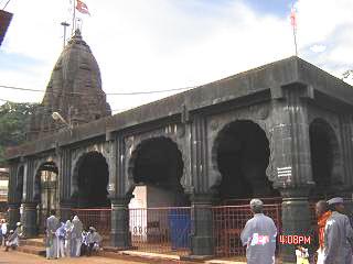
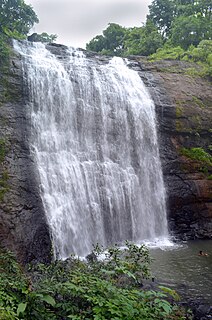
Bhimashankar Temple is a Jyotirlinga shrine located 50 km Khed taluka, near Pune, in Maharashtra, India. It is located 127 km from Shivajinagar in the Ghat region of the Sahyadri Mountains. Bhīmāshankar is also the source of the river Bhima, which flows southeast and merges with the Krishna river near Raichur. The other Jyotirlinga shrines in Maharashtra are Trimbakeshwar near Nashik and Grishneshwar.

Manmad pronunciation (help·info) is one of the towns in Nashik district in the state of Maharashtra in India. It is the third largest city in Nashik district, with a population of approximately 80,000. Geographically it lies within Nandgaon Tehsil in Nashik District. Though it has a larger area and population than most Tehsils in the district, it does not have a Tehsil office.

New Panvel is a residential, commercial and educational node of Navi Mumbai, Maharashtra and comes under the Konkan division. New Panvel was developed on marshy land and was previously a Mango cultivated area. New Panvel is divided into two parts: New Panvel (E), on the eastern side of Panvel railway station and Khanda Colony or New Panvel (W) on the western side of it. Both parts of New Panvel are connected by a flyover bridge also known as Khanda Colony Flyover. New Panvel (W) is also popularly called Khanda Colony by the local villagers, as the city is adjacent to two small villages Dhakta Khanda and Motha Khanda.
Igatpuri is a town and a Hill Station. It is also a municipal council in Nashik District in the Indian state of Maharashtra. It is located in the Western Ghats. Igatpuri railway station lies in Nashik District between Mumbai and Nashik Road on the Central Railway. Igatpuri is known for Vipassana International Academy, where ancient technique of meditation is taught called Vipassana. The place is one of the best places to visit in Maharashtra in monsoon. It is a hill station on busy Mumbai-Agra NH-3 only 45 km from Nashik and 130 km from Mumbai.

Khopoli is an industrial city in the Khalapur taluka of Raigad district, in the Indian state of Maharashtra, at the base of the Sahyadri mountains. Patalganga River, which is the tailrace channel of Tata Hydroelectric Power station, flows through Khopoli.
Chikhli is a city and a municipal council in Buldana district in Vidarbha Region of Maharashtra state, India. It is located on the Pune-Nagpur highway. It is situated at the westernmost border of Vidarbha region of Maharashtra and is 500 km from the state capital, Mumbai. Chikhli has the largest population in buldhana district and is the biggest taluka. Chikhli is situated on the border of the Marathwada Region and Vidarbha Regions of Maharashtra. Chikhli is the nearest municipal council to the district place, Buldana, approximately 25 km only. Also in addition, there is a cotton factory in Chikhli which provides employment to many people who comes in this city for employment purpose. MIDC is located on Nagpur-Pune highway where many small scale, middle scale and some large scale firms of automotive, chemical, fibres and plastic, iron casting and other sectors are situated. Textile park was sanctioned near city and land acquisition and other government processes are going on regarding this.

Chiplun is a city in Ratnagiri district in the state of Maharashtra, India. It is the financial and commercial Hub of Ratnagiri, and the headquarters of Chiplun taluka. It is about 320 km south of Mumbai in the Konkan region of Maharashtra, on the Mumbai–Goa highway (NH-66). It has a long history and a strong cultural background. Recent decades have seen much industrial development in it and its and surrounding areas.
Deolali, or Devlali, is a small hill station and a census town in Nashik district of the Indian state of Maharashtra.
Chakan is a census town in India, in Pune district of the Indian state of Maharashtra. While agriculture remains an important factor, the town's industrial development is quickly urbanizing the area.
Hadapsar is a developed town in eastern Pune City, Maharashtra. After 1990, Hadapsar developed into a major industrial area and is now one of the most densely populated and developed areas of Pune District. It is well connected to all parts of city. Distances to popular city centers is: Pune Railway Station 8 km, Lohegaon airport 8 km, Koregaon Park 5 km, Swargate Bus Stand 7 km and Shivaji Nagar Railway Station 12 km.

Chandwad (IPA:Cāndavaḍa) is a town located in the Nashik district in Maharashtra. It is 250 km from Mumbai. The 11th-century Jain Caves, Renuka devi mandir, Chandreshwar temple and Rangmahal are in Chandwad.

The economy of the state of Maharashtra is the largest in India. It is one of the most urbanised of Indian States.

Maharashtra attracts tourists from other Indian states and foreign countries. It was the second most visited Indian state by foreigners and fourth most visited state by domestic tourists in the country in 2014. Aurangabad is the tourism capital of Maharashtra.

Kandivali formerly Khandolee is a neighbourhood in the north Mumbai, Maharashtra, India and has a large Gujarati population. It is the 20th railway station on the western line from Churchgate. It is an upmarket locality.
The city of Nagpur is strategically located in central India. It has a vast railway network and its road network is well-maintained to avoid congestion. There are 4 modes of transportation in Nagpur. Nagpur is connected to India's four major metropolitan areas by road, rail and air. Auto rickshaws operate in most parts of the city, and are the main form of hired transport.
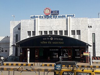
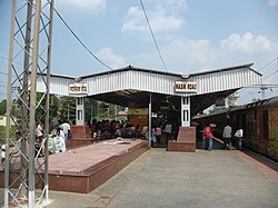
Nasik Road railway station serves Nashik city, Nashik Road and surrounding areas in Nashik district in the Indian state of Maharashtra. It is main railway station of Nashik. It is one of the busiest railway station in India. It is located on Mumbai–Delhi, Mumbai–Kolkata main line. It is A1 category railway station. It comes under Bhusawal Division of Central Railway. Nearly 300 trains have stops at this railway station. Approximately 2,00,000 people travel daily from this railway station. It is one of the cleanest railway station in India.
The Bhusawal–Kalyan section is part of the Howrah–Nagpur–Mumbai line and Howrah–Allahabad–Mumbai line. It connects Bhusawal and Kalyan both in the Indian state of Maharashtra. One of the branch lines, Jalgaon–Surat line, runs partly in Gujarat.
The Greater Nashik Metro or Metro NEO is a proposed rapid transit system in the Nashik Metropolitan Region. The system is proposed to reduce traffic congestion as well as provide direct connectivity to Nashik city from its suburbs. The Greater Nashik Metro will connect suburbs of Nashik city like Deolali, Nashik Road, Upnagar, Nashik Airport, Sinnar, Igatpuri, Gangapur Road, Trimbakeshwar, Dindori, Bhagur, Niphad, Adgaon, Ghoti and Girnare.