
Route 128, known as the Yankee Division Highway, is a state highway in the U.S. state of Massachusetts maintained by the Highway Division of the Massachusetts Department of Transportation (MassDOT). Spanning 57 miles (92 km), it is one of two beltways around Boston, and is known as the "inner" beltway, especially around areas where it is 15 miles (25 km) or less outside of Boston. The route's current southern terminus is at the junction of I-95 and I-93 in Canton, and it is concurrent with I-95 around Boston for 37.5 miles (60.4 km) before it leaves the interstate and continues on its own in a northeasterly direction towards Cape Ann. The northern terminus lies in Gloucester a few hundred feet from the Atlantic Ocean. All but the northernmost 3 miles are divided highway, with the remainder being a surface road. Its concurrency with I-95 makes up most of its length.

U.S. Route 22 is a west–east route and is one of the original United States highways of 1926, running from Cincinnati, Ohio, at US 27, US 42, US 127, and US 52 to Newark, New Jersey, at U.S. Route 1/9 in the Newark Airport Interchange.

U.S. Route 20 or U.S. Highway 20 (US 20) is an east–west United States Numbered Highway that stretches from the Pacific Northwest east to New England. The "0" in its route number indicates that US 20 is a major coast-to-coast route. Spanning 3,365 miles (5,415 km), it is the longest road in the United States, and, in the east, the route is roughly parallel to that of the newer Interstate 90 (I-90), which is the longest Interstate Highway in the U.S. There is a discontinuity in the official designation of US 20 through Yellowstone National Park, with unnumbered roads used to traverse the park.

U.S. Route 2 or U.S. Highway 2 (US 2) is an east–west U.S. Highway spanning 2,571 miles (4,138 km) across the northern continental United States. US 2 consists of two segments connected by various roadways in southern Canada. Unlike some routes, which are disconnected into segments because of encroaching Interstate Highways, the two portions of US 2 were designed to be separate in the original 1926 highway plan.
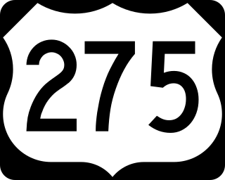
U.S. Route 275 (US 275) is a north–south United States highway that is a branch of US 75. It originally terminated at US 75 in Council Bluffs, Iowa. The highway's northern terminus is in O'Neill, Nebraska, at an intersection with U.S. Highway 20 and U.S. Highway 281. Its southern terminus is near Rock Port, Missouri, at an intersection with U.S. Highway 136.

U.S. Route 18 is an east–west U.S. highway in the Midwestern United States. The western terminus is in Orin, Wyoming at an interchange with Interstate 25. Its eastern terminus is in downtown Milwaukee, Wisconsin. However, US 18 runs concurrent with other U.S. routes from its western terminus to Mule Creek Junction, Wyoming. US 18 is one of the original United States highways of 1926. The US 18 designation was originally proposed for a road in Michigan from Grand Haven east to Detroit. This roadway was eventually designated as U.S. Route 16.

State Route 5 (SR 5) is a 155.325-mile-long (249.971 km) state highway that travels south-to-north through portions of Carroll, Douglas, Cobb, Cherokee, Pickens, Gilmer, and Fannin counties in the western and northern parts of the U.S. state of Georgia. The highway travels from its southern terminus at SR 48 at the Alabama state line, north-northwest of Ephesus, to its northern terminus at SR 60 and SR 68 at the Tennessee state line on the McCaysville–Copperhill line, bisecting the northwestern portion of the state.

State Route 532 is a north–south state highway in the northeastern portion of the U.S. state of Ohio. The highway runs from its southern terminus at a signalized intersection with U.S. Route 224 (US 224) on the Summit–Portage county line approximately 0.75 miles (1.21 km) south of Mogadore on the border of Springfield Township and Suffield Township to its northern terminus at a diamond interchange with Interstate 76 (I-76), at its exit 29 within the Tallmadge city limits.
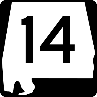
State Route 14 (SR 14) is a major east-to-west state highway in the U.S. state of Alabama. Spanning 218.289 miles (351.302 km), the highway begins at the Mississippi state line at the terminus of Mississippi Highway 69 and connects the cities of Selma and Prattville before ending at SR 147 on the western side of Auburn.

State Route 43 is a mainly north–south state highway that runs through the northeastern quadrant of the U.S. state of Ohio. Its southern terminus is at a signalized intersection with State Route 7 along the Ohio River in Steubenville, and its western terminus is approximately 123 miles (198 km) to the north at Public Square in Cleveland. It is one of ten routes to enter Public Square.

Curridabat is a district of the Curridabat canton, in the San José province of Costa Rica.

Curridabat is the eighteenth canton in the San José province of Costa Rica. The head city the homonymous Curridabat. The canton forms a suburb of the national capital of San José, lying on the southeast edge of the city.

Tirrases is a district of the Curridabat canton, in the San José province of Costa Rica.

National Primary Route 39, or just Route 39 is a National Road Route of Costa Rica, located in the San José province. Its official name is Paseo de la Segunda República, is also known as Carretera de Circunvalación, and is an incomplete ring road encircling the central districts of San José canton, the capital of the country.

National Primary Route 27, or just Route 27 is a National Road Route of Costa Rica, is a route which connects the Greater Metropolitan Area to Caldera Port and the Pacific coast of the country.
National Primary Route 1, formally known as Carretera Interamericana Norte, is the northern segment of the Pan-American Highway that traverses Costa Rica.

National Primary Route 2, formally known as Carretera Interamericana Sur, is the southern segment of the Pan-American Highway that traverses Costa Rica.
National Secondary Route 251, or just Route 251 is a National Road Route of Costa Rica, located in the San José, Cartago provinces.
National Secondary Route 221, or just Route 221 is a National Road Route of Costa Rica, located in the San José, Cartago provinces.
National Secondary Route 215, or just Route 215 is a National Road Route of Costa Rica, located in the San José province.

