Benito Juárez, is a borough in Mexico City. It is a largely residential area, located to the south of historic center of Mexico City, although there are pressures for areas to convert to commercial use. It was named after Benito Juárez, president in the 19th century.

Xochimilco is a borough of Mexico City. The borough is centered on the formerly independent city of Xochimilco, which was established on what was the southern shore of Lake Xochimilco in the precolonial period.

Naucalpan, officially Naucalpan de Juárez, is one of 125 municipalities located just northwest of Mexico City in the adjoining State of Mexico. The municipal seat is the city of Naucalpan de Juárez, which extends into the neighboring municipality of Huixquilucan.

Nativitas is a station on Line 2 of the Mexico City Metro system. It is located in the Colonia Nativitas and Colonia Lago neighborhoods of Benito Juárez borough of Mexico City, directly south of the city centre on Calzada de Tlalpan. It is a surface station.

Mexico is a predominantly Christian country, with adherents of Islam representing a small minority. Due to the secular nature of the state established by Mexico's constitution, Muslims are free to proselytize and build places of worship in the country. The country has a population of around 126 million as of 2020 census and according to the Pew Research Center, the Muslim population was 60,000 in 1980, 111,000 in 2010, and is predicted to be 126,000 in 2030; however, according to the 2010 National Institute of Statistics and Geography (INEGI) census, there were only 2,500 individuals who identified Islam as their religion. Most Muslims are foreign nationals and the majority are Sunni.
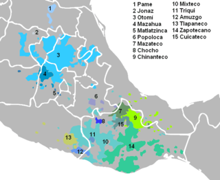
Chocho is a language of the Popolocan branch of the Oto-Manguean language family spoken in Mexico in the following communities of Oaxaca: San Miguel Chicahua, Teotongo, San Miguel Huautla, Santa Magdalena Jicotlán, San Pedro Nopala, San Miguel Tequixtepec, San Francisco Teopan, Ocotlán, Santa María Nativitas, San Juan Bautista Coixtlahuaca, and San Miguel Tulancingo. Chocho is spoken by 770 speakers.

Almoloya de Juárez is a town in the State of Mexico and the seat of the municipality of Almoloya de Juárez. The name Almoloya comes from the Nahuatl, that is properly Almoloyan, composed of: atl, "water"; molo "impersonal voice of moloni, to flow the source" and yan, "place"; that it means "place where flows the water source".

Bogliasco is a comune (municipality) in the Metropolitan City of Genoa in the Italian region Liguria, located about 11 kilometres (7 mi) southeast of Genoa. Together with the comuni of Camogli, Recco, Pieve Ligure and Sori, it is part of the so-called Golfo Paradiso. Economy is mostly based on tourism; agriculture include production of olives.
Jiquipilco Municipality is one of the municipalities of the State of Mexico in Mexico. It is north of the Toluca Valley, part of the region consisting of the southern and western slopes of Cerro La Catedral, which has a concentration of speakers of the Otomi language. It is about 40 km from Toluca, the state capital. The name is a corruption of Nahuatl “Xiquipilco”, meaning “in the saddlebags”. Jiquipilco is situated on the transversal volcanic axis that crosses Mexico in an area surrounded by lakes and volcanoes. This portion is called "Anahuac”.
Aculco is a municipality located in the Atlacomulco Region of the State of Mexico in Mexico. The name comes from Nahuatl. The municipal seat is the town of Aculco de Espinoza, although both the town and municipality are commonly referred to as simply "San Jerónimo Aculco".

Bachíniva is one of the 67 municipalities of Chihuahua, in northern Mexico. The municipal seat lies at Bachíniva. The municipality covers an area of 1,691.9 km2.
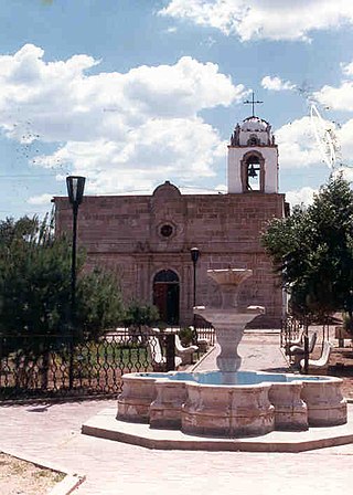
Bachíniva is a town and county in the Mexican state of Chihuahua. The town serves as the county seat for the surrounding municipality of the same name. It was founded by Franciscan missionaries on September 8, 1660, as Santa María de Nativitas Bachiniva. Bachiniva is a Rarámuri native Indian word which means the place of the wild pumpkin flower. With the arrival of the Franciscan missionaries to the area, most natives left their settlement rejecting the evangelization process of the catholic church. Some of the natives however were converted to the new religion and the mission of Santa Maria de Nativitas Bachíniva was founded with a church that still stands today. Later on, Spanish immigrants and Mexican from the south of Mexico settled in the area along the fertile lands of the Santa Maria River. The Spanish missionaries found the area ideal for the growing and production of apples and they planted the first apple trees in the late 1600s and ever since the people of this municipality have been growing great apple crop along with other fruits and agricultural products. The apple production though is the main economic activity of the Bachiniva municipality.

Almolya del Río is a town and municipality located in the State of Mexico 26 km from the state capital of Toluca. It is located 2,600 meters above sea level. The name Almoloya comes from the Nahuatl phrase almoloyán which means place where water flows out. "del Rio" means "of the river" in Spanish and refers to the Lerma River, which originates here.

Calimaya is a town and municipality located just south of Toluca, the capital of the State of Mexico in central Mexico. The settlement was probably established around 800 BCE, when the city of Teotenango was in existence. It remained an important town through the colonial period, part of the vast lands held by a family which came to be known as the Counts of Calimaya. The town is home to one of the oldest examples of an open chapel in the State of Mexico. Today, the municipality is still mostly agricultural but there has been a rapid construction of housing divisions, changing parts of it from rural to suburban.

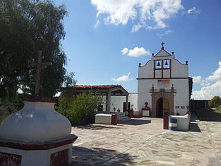
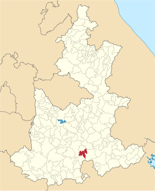
Santa María Nativitas is a town and municipality in Oaxaca in south-western Mexico. The municipality covers an area of km². It is part of the Coixtlahuaca district in the Mixteca Region.
Coyotepec is a municipality in the Mexican state of Puebla. The name comes from the Nahuatl words coyotl (coyote) and tepetl (hill)

Santa Ana Nopalucan is a town and its surrounding municipality in the Mexican state of Tlaxcala.
Los Remedios National Park is a national park in Mexico, located in the far west of the municipality of Naucalpan in Mexico State, just northwest of Mexico City. The park was established by federal decree in 1938 with an area of 400 hectares. Within its borders is the Sanctuary of the Virgin of Los Remedios, a colonial-era aqueduct and a pre-Hispanic archaeological zone with a Chichimeca temple. All of these are located in and around the mountain called Cerro Moctezuma. The site was an Aztec observatory and is also believed to be where Hernán Cortés and his men rested after fleeing Tenochtitlan.

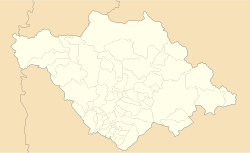
Coixtlahuaca District is located in the northeast of the Mixteca Region of the State of Oaxaca, Mexico. As of 2005 the population was 9,018, down 2.8% from 2000.
Ocuiltec, also known as Tlahuica and Atzingo Matlatzinca, is a moribund language of Central Mexico closely related to Matlatzinca and Pirinda.