Related Research Articles

Aleknagik Airport, also known as Aleknagik (New) Airport, is a state-owned, public-use airport located one nautical mile (1.85 km) east of the central business district of Aleknagik, a city in the Dillingham Census Area of the U.S. state of Alaska.

Sierra Blanca Regional Airport is a public use airport located on the Fort Stanton mesa 15 nautical miles (28 km) northeast of the central business district of Ruidoso, a village in Lincoln County, New Mexico, United States. It is owned by the Village of Ruidoso. According to the FAA's National Plan of Integrated Airport Systems for 2009–2013, it is classified as a general aviation airport.
Healy River Airport is a state owned, public use airport serving Healy, a community located in the Denali Borough of the U.S. state of Alaska. It is included in the National Plan of Integrated Airport Systems for 2011–2015, which categorized it as a general aviation facility.
Kayenta Airport is a public use airport located 2.3 miles southeast of the central business district of Kayenta, in Navajo County, Arizona, United States. It is owned by Kayenta Township, which is part of the Navajo Nation.
Chinle Municipal Airport, also referred to as Chinle Airport, is a public-use airport located 4 miles southwest of the central business district of Chinle, in Apache County, Arizona, United States. It is owned by the Navajo Nation.

Camden Municipal Airport is a city-owned, public-use airport located three nautical miles (6 km) southwest of the central business district of Camden, a city in Wilcox County, Alabama, United States.

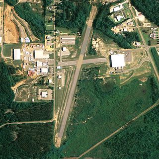
Clayton Municipal Airport is a city-owned, public-use airport located two nautical miles west of the central business district of Clayton, a city in Barbour County, Alabama, United States.
Carl Folsom Airport is a public-use airport located two nautical miles west of the central business district of Elba, a city in Coffee County, Alabama, United States. It is owned by the Elba Airport Authority.

Lanett Municipal Airport is a city-owned public-use airport located three nautical miles southwest of the central business district of Lanett, a city in Chambers County, Alabama, United States. According to the FAA's National Plan of Integrated Airport Systems for 2009–2013, it is categorized as a general aviation facility.
Perryville Airport is a state-owned, public-use airport located one nautical mile southwest of the central business district of Perryville, in the Lake and Peninsula Borough of the U.S. state of Alaska. Scheduled airline service to King Salmon Airport is provided by Peninsula Airways (PenAir).
Levelock Airport , public-use airport located one nautical mile (1.85 km) north of the central business district of Levelock, in the Lake and Peninsula Borough of the U.S. state of Alaska. Scheduled airline service to King Salmon Airport is provided by Grant Aviation.
Chignik Lagoon Airport is a state-owned, public-use airport serving Chignik Lagoon, in the Lake and Peninsula Borough of the U.S. state of Alaska. It is also known as Chignik Flats Airport. Scheduled airline service to King Salmon Airport is provided by Grant Aviation.
Chignik Airport is a state-owned, public-use airport two nautical miles (3.7 km) northeast of the central business district of Chignik, a city in the Lake and Peninsula Borough of the U.S. state of Alaska.
Portales Municipal Airport is a city-owned, public-use airport located four nautical miles southwest of the central business district of Portales, a city in Roosevelt County, New Mexico, United States. According to the FAA's National Plan of Integrated Airport Systems for 2009–2013, it is classified as a general aviation airport.
Lake Chelan Airport, formerly known as Chelan Municipal Airport, is a public use airport located three nautical miles (6 km) northeast of the central business district of Chelan, a city in Chelan County, Washington, United States. The airport is owned by the City of Chelan/Port of Chelan. According to the FAA's National Plan of Integrated Airport Systems for 2009–2013, it is categorized as a general aviation facility.
Kokhanok Airport is a state-owned public-use airport located two nautical miles (3.7 km) southwest of the central business district of Kokhanok, in the Lake and Peninsula Borough of the U.S. state of Alaska.

Kantishna Airport is a state-owned airstrip located two nautical miles (3.7 km) northwest of the former mining district of Kantishna in Denali National Park and Preserve, Alaska.
Nondalton Airport is a state-owned public-use airport located one nautical mile (1.85 km) northwest of the central business district of Nondalton, in the Lake and Peninsula Borough of the U.S. state of Alaska.
Pedro Bay Airport is a state-owned public-use airport located one nautical mile (1.85 km) west of the central business district of Pedro Bay, in the Lake and Peninsula Borough of the U.S. state of Alaska.
Schroon Lake Airport is a public-use airport located two nautical miles north of the central business district of Schroon Lake, a town in Essex County, New York, United States. It is owned by the Town of Schroon Lake. This airport is included in the FAA's National Plan of Integrated Airport Systems for 2009–2013, which categorized it as a general aviation facility.
References
- 1 2 3 FAA Airport Form 5010 for 1V0 PDF . Federal Aviation Administration. Effective 5 October 2022.
- ↑ National Plan of Integrated Airport Systems for 2009–2013: Appendix A: Part 4 (PDF, 1.61 MB) Archived 2011-06-06 at the Wayback Machine . Federal Aviation Administration. Updated 15 October 2008.