Related Research Articles

Adamawa State is a state in the North-East geopolitical zone of Nigeria, bordered by Borno to the northwest, Gombe to the west, and Taraba to the southwest while its eastern border forms part of the national border with Cameroon. It takes its name from the historic emirate of Adamawa, with the emirate's old capital of Yola serving as the capital city of Adamawa State. The state—one of the most heterogeneous in Nigeria with over 100 indigenous ethnic groups—was formed in 1991 when the former Gongola State was broken up into Adamawa and Taraba states.

The Adamawa Region is a constituent region of the Republic of Cameroon. It borders the Centre and East regions to the south, the Northwest and West regions to the southwest, Nigeria to the west, the Central African Republic (CAR) to the east, and the North Region to the north.
Taraba is a state in North Eastern Nigeria, named after the Taraba River which traverses the southern part of the state. Taraba's capital is Jalingo. The inhabitants are mainly the Fulani, Jukun, Chamba, Tiv, Kuteb and the Ichen who are found predominantly in the southern part of the state. while Jenjo, Wurkum, Mumuye, and Kona tribes are predominantly located in the northern part of the state. The central region is mainly occupied by the Mambila people, Chamba, Fulani and Jibawa. There are over 77 different tribes, and their languages in Taraba State.

Muri is a town and traditional emirate in Jalingo but covers Karim Lamido LGA ARDO KOLA Yoro, Taraba LGA and others, in northwestern Taraba State, eastern Nigeria, approximately between 9° and 11° 40′ E. and 7° 10′ and 9° 40′ N. The Benue River is nearby, and the portion on the southern bank of the river is watered by streams flowing from the Cameroon region to the Benue. In 1991, the town was estimated to have a population of 56,570. The valley of the Benue has a climate generally unhealthy to Europeans but there are places in the northern part of the province, such as the Fula settlement of Wase on a southern spur of the Murchison hills, where the higher altitude gives an excellent climate.
Sardauna Local Government Area is located in the extreme southeast of Taraba State in Nigeria. It sits atop the Mambilla Plateau, which is dotted by other towns such as Maisamari and Nguroje. The capital of the LGA is Gembu, which is the principal town of various ethnic groups, such as Mambilla, Kaka, Fulani, Ndola, Tigon, Kambu, Chamba and Panso. Other ethnic groups from the mainstream Nigeria and the bordering Cameroon republic such as Hausa and Kanuri also live there.
The Mambilla or Mambila people of Nigeria live on the Mambilla plateau. A small fraction of Mambilla migrants left the Mambilla Plateau for the Ndom Plain on the Cameroon side of the international border as well as in a couple of small villages, such as New Namba, further north towards the towns of Gashaka and Banyo. The preferred ethnonym is spelt Mambila in Cameroon and Mambilla in Nigeria. "Norr" is also used.

The Cameroonian Highlands forests, also known as the Cameroon Highlands forests, are a montane tropical moist broadleaf forest ecoregion located on the range of mountains that runs inland from the Gulf of Guinea and forms the border between Cameroon and Nigeria. This is an area of forest and grassland which has become more populous as land is cleared for agriculture.
The twelve Mambiloid languages are languages spoken by the Mambila and related peoples mostly in eastern Nigeria and in Cameroon. In Nigeria the largest group is Mambila. In Cameroon the largest group is Vute.
Dorofi is a small town on the Mambilla Plateau in Taraba State in Central Eastern part of Nigeria. It is 40 km from Gembu, the Sardauna Local Government Area headquarters. It is located on Nigeria's border with Cameroon Republic. It has a temperate climate, with a mean air temperature of 17.5 °C (63.5 °F). It is among the coldest towns in Nigeria. Dorofi's landscape consists of hills and valleys. The people of Dorofi engage in small-scale farming down the hills and cattle grazing up the hills. Views from different sites of Dorofi show plantations of eucalyptus, used for building materials as well as a source of energy for domestic work and warming in cold winters.
Kurmi is a Local Government Area in Taraba State, Nigeria. As a local government area it is administered by a Local Government Council consisting of a chairman, and elected councillors. The LGA is further divided into wards. Its headquarters are in the town of Ba'Issa.
The Christian Reformed Church of Nigeria (CRC-N) is a Christian church that was established in 1951 under the name "Ekklisiyar Kristi a Sudan (EKAS) Lardin "Benue" meaning, "The church of Christ in Sudan, Benue region", and known under its current name since 1976. It belongs to the Fellowship of Churches of Christ in Nigeria and the World Communion of Reformed Churches.

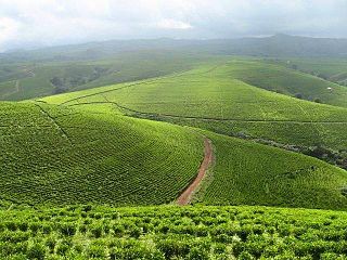
The Mambilla Plateau is a plateau in the Taraba State of Nigeria. The plateau is Nigeria's northern continuation of the Bamenda Highlands of Cameroon. The Mambilla Plateau has an average elevation of about 1,600 metres (5,249 ft) above sea level, making it the highest plateau in Nigeria. Some of its villages are situated on hills that are at least 1,828 metres (5,997 ft) above sea level. Some mountains on the plateau and around it are over 2,000 metres (6,562 ft) high, like Chappal Waddi which has a height of 2,419 metres (7,936 ft) above sea level. It is the highest mountain in Nigeria and in West Africa. The Mambilla Plateau measures about 96 km (60 mi) along its curved length; it is 40 km (25 mi) wide and is bounded by an escarpment that is about 900 m (2,953 ft) high in some places. The plateau covers an area of over 9,389 square kilometres (3,625 sq mi).

Gembu is a town on the Mambilla Plateau in Taraba State of Nigeria. It is the headquarters of Sardauna Local Government Area in Taraba State.

The Kuteb people are an ethno-linguistic group in West Africa, who speak Kuteb, a Jukunoid language. Most of the Kuteb people reside in Taraba State, Nigeria.
Mambila is a dialect chain stretching across Nigeria and Cameroon. It is one of the Mambiloid languages, a branch of Benue–Congo.
Dadiya is one of the Savanna languages of northeastern Nigeria. They are found in Gombe, Adamawa & Taraba state. The Dadiya people of Gombe State are found in Balanga local government, while those in Adamawa and Taraba are found spread in Lamurde and Karim-Lamido Local government area respectively.
Mvanip (Mvano), or Magu, is a minor Mambiloid language of Nigeria. Despite the small number of speakers, language use is vigorous. Ethnologue classifies Mvanip as threatened.
Njerep (Njerup) is a Mambiloid language spoken in the Adamawa Region of Cameroon. Njerep is essentially extinct, with only 4 people who speak it at home. Though word lists and grammatical information have been collected from these people, the information remains fragmented.

Charles Kingsley Meek, or just C. K. Meek, was a British anthropologist. He wrote about the northern tribes of Nigeria and studied the Jukun people. Meek took photographs during some of his field work.
The Ndola of Gola Area Development Association (NGADA) is a development area located in Taraba State, Nigeria.
References
- ↑ "Rescue Team Storms Ndola Community". Taravoices. Retrieved 2016-11-30.
- ↑ Yakubu Ishaku (2016). "Ndola in Nigeria". joshuaproject.net. Retrieved 2017-05-07.
- ↑ Multitree (2011). "Ndoro". multitree.org. Retrieved 2017-05-07.
- ↑ S. Beban Chumbow (2007). "Classification of the Languages of Cameroon and Equatorial Guinea on the Basis of Lexicostatistics and Mutual inteligibility" (PDF). Africa Study Monographs. Retrieved 2017-05-09.
- ↑ Rev. Elder Amos Adi (2005). "Brief History of the CRCN Baissa". crcn-ng.com. Retrieved 2017-05-09.