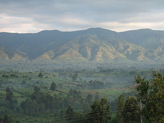
North Kivu is a province bordering Lake Kivu in the eastern Democratic Republic of the Congo. The capital city is Goma. Spanning approximately 59,483 square kilometers with a population estimate of 8,147,400 as of 2020, it is bordered by Ituri Province to the north, Tshopo Province to the northwest, Maniema Province to the southwest, and South Kivu Province to the south, as well as Uganda and Rwanda to the east.

The Third Republic of the Democratic Republic of the Congo is a unitary state with a five-level hierarchy of types of administrative division. There are nine different types of country subdivision in a new hierarchy with no new types but with two from the previous one abolished.
Karisimbi is a commune in Goma in the North Kivu Province of the eastern region of the Democratic Republic of the Congo. The commune takes its name from the nearby Mount Karisimbi, a prominent volcano in the Virunga Mountains. Spanning an area of approximately 33,372 square kilometers, Karisimbi extends from Goma International Airport to the outskirts of the Mugunga neighborhood. It is bordered by the Masisi Territory to the south and Rwanda to the east.

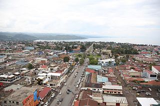
Goma is the capital and largest city of the North Kivu Province in the eastern region of the Democratic Republic of the Congo. It is located on the northern shore of Lake Kivu and shares borders with Bukumu Chiefdom to the north, Rwanda to the east and Masisi Territory to the west. The city lies in the Albertine Rift, the western branch of the East African Rift, and is only 13–18 km (8.1–11.2 mi) south of the active volcano Mount Nyiragongo. With an approximate area of 75.72 km2 (29.24 sq mi), the city has an estimated population of nearly 2 million people in 2022, with at least 500,000 displaced people.

Mont Ngafula, or Mont-Ngafula, is a commune in the Lukunga District of Kinshasa, in the western part of the Democratic Republic of the Congo. By its surface area, Mont Ngafula is the third-largest commune in Kinshasa's city-province. It is located in the hilly southern area of Kinshasa and is intersected by the Lukaya River valley in its southern portion. The boundary with the Ngaliema commune is defined by the Lukunga River. Mont Ngafula shares borders with the Makala commune to the north, the Kongo Central Province to the south, the Lemba and Kisenso communes to the east, and the Selembao commune to the west. It has an estimated population of 718,197 (2015).
Bandalungwa is a commune in the Funa District of Kinshasa in the western region of the Democratic Republic of the Congo. Covering an area of 6.82 square kilometers, Bandalungwa is centrally situated within the city. It is bordered by the Gombe commune and the Kokolo military barracks to the north, Selembao to the south, the communes of Ngiri-Ngiri, Kasa-Vubu, and Lingwala to the east, and the Makelele River, Ngaliema, and Kintambo to the west. The commune had an estimated population of 934,821 in 2015, although official census data from 2016 reported a significantly lower figure of 259,760 residents.

Goma International Airport, colloquially known by its acronym AIG based on its French name, is the primary international airport serving Goma, the capital of North Kivu province in the Democratic Republic of the Congo. Located in the Karisimbi commune, the airport lies approximately 2 kilometers from Goma's city center, strategically positioned between the active Nyiragongo volcano to the north and the gas-laden Lake Kivu. The airport is situated along the road to Rutshuru and is bordered by Murara, Virunga, and Majengo neighborhoods to the east and west, Mikeno (Birere) to the south, and Majengo to the north.

The Régie de Distribution d'Eau, abbreviated as REGIDESO, is a state-owned utility company located on Boulevard Du 30 Juin, in the Gombe commune of Kinshasa, Democratic Republic of the Congo (DRC). It is responsible for producing and distributing water throughout the national territory, encompassing both urban and rural areas. Established in 1929, REGIDESO operates autonomously under the oversight of the Ministry of Energy and the Portfolio.
Mulenge is a village encircled by hills in the Kigoma groupement (grouping), within Bafuliiru Chiefdom, located in the Uvira Territory, South Kivu, in the eastern Democratic Republic of the Congo. It is situated on the high plateaus of the Itombwe massif, overlooking the locality of Uvira. The area has conventionally been inhabited by various ethnic groups, including the remnants of the autochthonous population of African Pygmies, as well as Bantu ethnic groups such as the Mbuti, Fuliiru, and Nyindu. The region boasts high agricultural productivity, with two harvests typically achievable each year.

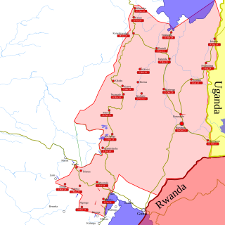
Rutshuru Territory is a territory in the North Kivu province of the eastern Democratic Republic of the Congo (DRC), with headquarters is the town of Rutshuru.

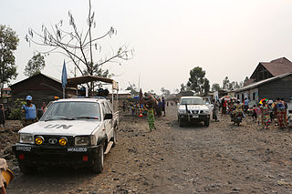
The March 23 Movement, often abbreviated as M23 and also known as the Congolese Revolutionary Army, is a Congolese Tutsi-led rebel military group. Based in eastern areas of the Democratic Republic of the Congo (DRC), it operates mainly in the province of North Kivu, which borders both Uganda and Rwanda, and is backed by Rwanda. The M23 rebellion of 2012 to 2013 against the DRC government led to the displacement of large numbers of people. On 20 November 2012, M23 took control of Goma, a provincial capital with a population of a million people, but it was requested to evacuate it by the International Conference on the Great Lakes Region because the DRC government had finally agreed to negotiate. In late 2012, Congolese troops, along with UN troops, retook control of Goma, and M23 announced a ceasefire and said that it wanted to resume peace talks.
Nyiragongo Territory is a territory in North Kivu, Democratic Republic of the Congo.
Goma is a commune located in the city of Goma, within North Kivu Province in the eastern Democratic Republic of the Congo. Covering an area of 33,245 square kilometers, it forms the southernmost part of the city while also including sections of its eastern and western regions. As of 2018, the commune's population was estimated at approximately 333,727 residents. Goma is bordered by Lake Kivu to the south, the Republic of Rwanda to the east, Karisimbi commune to the north, and Masisi Territory to the west.

Lubero is a town in the North Kivu Province of the Democratic Republic of the Congo. It is the administrative center of the Lubero Territory. Following the surrender of the Mai-Mai fighters in 2021, construction of a new market began in 2022, involving the mayor, ex-soldiers, "young people at risk and the vulnerable women". As of March 2014, the population of Lubero is not publicly known.

The Festival Amani is an annual festival that takes place in the context of peacebuilding in the Democratic Republic of Congo and the Great Lakes region. Amani is the Swahili word for Peace.
In late March 2022, the March 23 Movement (M23), supported by Rwanda, launched an offensive in North Kivu against the Armed Forces of the Democratic Republic of the Congo (FARDC), and MONUSCO. The fighting displaced hundreds of thousands of civilians and caused renewed tensions between the Democratic Republic of the Congo and Rwanda.
The Bwito Chiefdom is a chiefdom located in the Rutshuru Territory of North Kivu Province in the Democratic Republic of the Congo (DRC). It is bordered to the north by Batangi Chiefdom and Kanyabayonga commune in Lubero Territory, Bwisha Chiefdom in the east, and to the north-east by Lake Edward and the Republic of Uganda. To the west, it is bordered by Bashali Chiefdom in Masisi Territory, and to the northwest by Wanyanga Chiefdom in Walikale Territory. To the south, it is bordered by Nyiragongo Territory.
The Free University of the Great Lakes Countries, is a private Christian educational institution located in Goma, in the North Kivu Province of the eastern region of the Democratic Republic of the Congo. ULPGL was founded in 1985, as a result of the Institut Supérieur de Théologie Protestante and was granted university status by the government in 1991. It is sponsored by six Protestant denominations, including two Baptists, two Pentecostals, one Anglican (EAC), and one Methodist (CLMC).
The Bukumu Chiefdom is a chiefdom located in the Nyiragongo Territory of the North Kivu Province in the eastern region of the Democratic Republic of the Congo. It is bounded to the north by Bwisha Chiefdom in Rutshuru Territory, to the south by Goma, to the east by Rwanda, and to the west by Masisi Territory. The population is estimated at 338,966 as per the 2022 census.

Katindo is a neighborhood in the Goma commune of Goma, located in North Kivu, Democratic Republic of the Congo. Strategically located in the northern region of the city, it had an estimated population of 50,860 as of 2014. The neighborhood is situated north of the Goma-Sake road and south of Lake Kivu, with Les Volcans neighborhood to the east and Himbi to the west. Administratively, Katindo is divided into three cells and eight avenues.

