
Livingston Parish is a parish located in the U.S. state of Louisiana. Livingston Parish is known as one of the six Florida Parishes, a region of the State of Louisiana that was bought from Spanish Florida and created the state of Louisiana as it is known today.

Louisiana Highway 22 (LA 22) is a state highway located in southeastern Louisiana. It runs 71.15 miles (114.50 km) in a general east–west direction from the junction of LA 75 and LA 942 in Darrow to U.S. Highway 190 (US 190) in Mandeville.
Holden is an unincorporated community located on U.S. Highway 190 between Albany and Livingston in Livingston Parish, Louisiana, United States. Holden is in a section of land awarded to Micajah Spillars by a Spanish land grant. LA Hwy 441 which runs through Holden in a northwest-southeast direction is the road that connected Springfield with Baton Rouge to the west and points in Mississippi to the east. In 1907, the east-west line of the Baton Rouge, Hammond & Eastern Railroad was constructed.
The Tickfaw River runs 113 miles (182 km) from Amite County in southwest Mississippi to Livingston Parish in southeast Louisiana. Its mouth opens into Lake Maurepas, which conjoins with Lake Pontchartrain.
The Tangipahoa River originates northwest of McComb in southwest Mississippi, and runs south 122 miles (196 km) through Lake Tangipahoa in Percy Quin State Park before passing into southeast Louisiana. There it flows entirely in the eponymous Tangipahoa Parish until its mouth opens into the northwest region of Lake Pontchartrain.
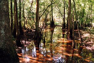
Tickfaw State Park, located 7 mi (11 km) west of Springfield, in Livingston Parish, Louisiana, opened in May 1999 and quickly became one of Louisiana's most popular state parks because of its natural setting, recreation opportunities, and proximity to the state's two largest metropolitan areas of New Orleans and Baton Rouge. The park contains a nature center, picnic shelters, a large fishing pond, 14 cabins, and 50 campsites.

Louisiana Highway 43 (LA 43) is a state highway located in southeastern Louisiana. It runs 44.38 miles (71.42 km) in a north–south direction from LA 42 west of Springfield to the Mississippi state line north of Easleyville, where it continues as Mississippi Highway 568 (MS 568).

Charlieville is an unincorporated community in Richland Parish, Louisiana, United States. The community is located 17 miles SE of Monroe, Louisiana.
Scott Landing is an unincorporated community in Madison Parish, Louisiana and Richland Parish, Louisiana, United States. The community is located 5 miles SE. of Dunn, Louisiana.
Lees Landing is an unincorporated community in Tangipahoa Parish, Louisiana, United States. The community is located 7 miles SE of Ponchatoula, Louisiana.
Wadesboro is an unincorporated community in Tangipahoa Parish, Louisiana, United States. The community is located 2 miles southwest of Ponchatoula, Louisiana.
Catfish Landing is an unincorporated community in Livingston Parish, Louisiana, United States. The community is located less than 2 miles east of Maurepas and 5 miles southwest of Killian on the bank of Amite River.
Clio is an unincorporated community in Livingston Parish, Louisiana, United States. The community is located 3 miles southwest of Killian and 3 miles east of Maurepas on the east bank of Amite River. Clio is only a few feet above sea level and almost completely surrounded by swamps with a small entrance from the northwest side.
Denson also known as Bear Island is an unincorporated community in Livingston Parish, Louisiana, United States. The community is located 2 miles southeast of Maurepas and 6 miles southwest of Killian north of the Blind River.
Horse Bluff Landing is an unincorporated community in Livingston Parish, Louisiana, United States. The community is located less than 3 miles west of Killian and 5 miles northeast of Maurepas on the bank of Tickfaw River. The Tickfaw State Park is located 1 mile to the northwest across the Tickfaw River.
Oldfield is an unincorporated community in Livingston Parish, Louisiana, United States. The community is located 9 miles north of Walker and 4 miles southeast of Baywood.
Van Buren is an unincorporated community in Livingston Parish, Louisiana, United States. The community is located less than 4 miles south of Holden and 6 miles southeast of Livingston near the Tickfaw River.
Aubin is an unincorporated community in East Baton Rouge Parish, Louisiana, United States. The community is located 4 miles to the southeast of Baton Rouge and less than 2 miles northeast of Westminster and 7 miles east of the Mississippi River.
Istrouma is an unincorporated community in East Baton Rouge Parish, Louisiana, United States. The community is located less than 2 miles northwest of Baton Rouge and 7 miles south of Baker.


