
Kochi, also known by its former name Cochin, is a major port city along the Malabar Coast of India bordering the Laccadive Sea. It is part of the district of Ernakulam in the state of Kerala. The city is also commonly referred to as Ernakulam. As of 2011, the Kochi Municipal Corporation had a population of 677,381 over an area of 94.88 km2, and the larger Kochi urban agglomeration had over 2.1 million inhabitants within an area of 440 km2, making it the largest and the most populous metropolitan area in Kerala. Kochi city is also part of the Greater Cochin development region and is classified as a Tier-II city by the Government of India. The civic body that governs the city is the Kochi Municipal Corporation, which was constituted in the year 1967, and the statutory bodies that oversee its development are the Greater Cochin Development Authority (GCDA) and the Goshree Islands Development Authority (GIDA).
Ernakulam is one of the 14 districts in the Indian state of Kerala, and takes its name from the eponymous city division in Kochi. It is situated in the central part of the state, spans an area of about 2,924 square kilometres (1,129 sq mi), and is home to over 9% of Kerala's population. Its headquarters are located at Kakkanad. The district includes Kochi, also known as the commercial capital of Kerala, which is famous for its ancient churches, Hindu temples, synagogues and mosques.

Idukki is one of the 14 districts in the Indian state of Kerala in the southwest of the country. It is the largest district in Kerala and lies amid the Cardamom Hills of Western Ghats in Kerala. Idukki district contains two municipal towns – Kattappana and Thodupuzha, and five taluks.

Muvattupuzha is a municipality in the Ernakulam district of Kerala, India. It is located 26 km (16.2 mi) east of the district headquarters in Thrikkakara and about 170 km (105.6 mi) north of the state capital Thiruvananthapuram. As per the 2011 Indian census, Perumbavoor has a population of 30,397 people, and a population density of 2,306/km2 (5,970/sq mi).
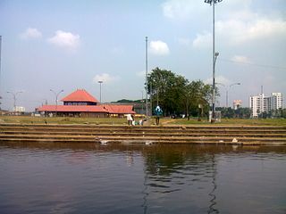
Aluva is an eastern suburb of the city of Kochi in Kerala, India. It is a part of the Kochi metropolitan area and is situated around 15 km (9.3 mi) from the city centre on the banks of Periyar River. A major transportation hub, with easy access to all major forms of transportation, Aluva acts as a corridor which links the highland districts to the rest of Kerala. Cochin International Airport at Nedumbassery is 11.7 km from Aluva. Aluva is accessible through rail, air, metro along with major highways and roadlines. Aluva KSRTC bus station is an important transport hub in Kerala and one of the busiest stations in central part of the state.

Periyar, IPA:[peɾijɐːr], is the longest river and the river with the largest discharge potential in the Indian state of Kerala. It is one of the few perennial rivers in the region and provides drinking water for several major towns. The Periyar is of utmost significance to the economy of Kerala. It generates a significant proportion of Kerala's electrical power via the Idukki Dam and flows along a region of industrial and commercial activity. The river also provides water for irrigation and domestic use throughout its course besides supporting a rich fishery. Due to these reasons, the river has been named the "Lifeline of Kerala". Kochi city, in the vicinity of the river mouth, draws its water supply from Aluva, an upstream site sufficiently free of seawater intrusion. Twenty five percent of Kerala's industries are along the banks of the Periyar. These are mostly crowded within a stretch of 5 kilometres (3 mi) in the Eloor-Edayar region (Udhyogamandal), about 10 kilometres (6 mi) north of Kochi harbor.

Madhyamam is a Malayalam-language newspaper published in Kerala, India, since 1987. It was founded by Ideal Publications Trust run by the Jamaat-e-Islami Hind wing in Kerala. It has nine editions in India and its Persian Gulf edition Gulf Madhyamam has nine in the Middle East.

The Idukki Dam is a double-curvature arch dam constructed across the Periyar River in a narrow gorge between two granite hills locally known as Kuravan and Kurathi in Idukki district in the state of Kerala, India. It is constructed and owned by the Kerala State Electricity Board. It supports a 780 MW hydroelectric power station in Moolamattom, which started generating power on 4 October 1975. At 168.91 metres (554.2 ft), it is one of the highest arch dams in Asia. The Indo-Canadian project was inaugurated by the Prime Minister Indira Gandhi on February 17, 1976.

Cochin Port or Kochi Port is a major port on the Arabian Sea – Laccadive Sea – Indian Ocean sea-route in the city of Kochi in Ernakulam district in the state of Kerala and is one of the largest ports in India. It is also the first transshipment port in India. The port lies on two islands in the Vembanadu Lake Willingdon Island and Vallarpadam, towards the Fort Kochi river mouth opening onto the Laccadive Sea. The International Container Transshipment Terminal (ICTT), part of the Cochin Port, is the largest container transshipment facility in India.

Bhoothathankettu is a dam and tourist spot in Ernakulam district in Kerala,. It is situated outside the village of Pindimana, about 10 km away from the town of Kothamangalam and 50 km away from the main city of Kochi. The original natural dam has been supplemented by a modern dam impounding the Bhoothathankettu Reservoir.

The Kochi Metro is a rapid transit system serving the city of Kochi and the wider Kochi Metropolitan Region in Kerala, India. It was opened to the public within four years of starting construction, making it one of the fastest completed metro projects in India. The Kochi metro project is the first metro system in the country which connects rail, road and water transport facilities. It is also the first metro rail system in India to be operated using the Communication-Based Train Control (CBTC) signalling system, which requires minimum human intervention. The Kochi Water Metro is integrated with the Kochi Metro, which also serves as a feeder service to the suburbs along the rivers where transport accessibility is limited.
Adimali is a town in the Idukki district of Kerala, in southwesternIndia. National Highway 185 is a highway in India running from Adimali to Kumily through Kattappana and ends in Adoor in Kerala. Adimaly is located on the National Highway 49, now NH 85, known as Kochi-Dhanushkodi National Highway, earlier known as the Kochi Madhura Highway (India) connecting Kochi and Madurai, India. From Adimaly, it is only 27 kilometers to Munnar, which is a famous hill station. The waterfalls Cheeyappara, Adimali waterfalls and Valara are located nearby. Pepper and cocoa cultivation is the main agricultural activity of this place. The Ponmudi Dam was constructed in 1963 across the Panniar river, nearly 15 km southeast of Adimali, on the way to Rajakkad.Thopramkudy is the nearest town. Adimali is known for its proximity to Munnar and natural environment. Adimali has almost all the basic facilities like roads, super markets, markets, educational institutions and hospitals.

The Varapuzha bridge on NH 17 is a cantilever bridge spanning the Periyar river between Varappuzha and Cheranallur in Kochi, India. Varapuzha Bridge is the first bridge in Kerala to be constructed using Balanced Cantilever technique(120m span) and also the first bridge in Kerala where Caisson floating technique was adopted. The construction of the bridge won the National award for the Most Outstanding Bridge(1999) of Indian Institution of Bridge Engineers On 16 January 2001, Varapuzha Bridge was opened to traffic. This bridge reduces the distance between Malabar and Kochi.

Pizhala is an island village, one among the fourteen islands of Kadamakkudy archipelago, located near to the main land of the city Ernakulam. The island is surrounded by tributaries of river Periyar. Pizhala island is part of Kadamakkudy village of Kanayannur taluk in Ernakulam district in the state of Kerala, India.
The Great flood of '99 (Malayalam:'തൊണ്ണൂറ്റി ഒമ്പതിലെ വെള്ളപ്പൊക്കം' occurred when the Periyar River in Kerala state of India flooded in the month of July 1924. This happened in the year 1099 ME in the Malayalam Calendar. As the Malayalam Calendar was popular in Kerala, the flood is generally referred to as "The Great flood of "99".The rain continued for about three weeks. Many districts of present-day Kerala were deeply submerged by the flood - from Thrissur, to Ernakulam to Idukki, Kottayam even up to Alappuzha and Kuttanad. A huge mountain called Karinthiri Mala was washed away by this flood and the road to Munnar also went along with it. As the road to Munnar was lost by this flood, a new road from Ernakulam to Munnar became necessary - the present day road from Ernakulam to Munnar was constructed after this. Kundala Valley Railway which was the first monorail system in India was also completely destroyed. Various remnants of the old Railway systems still exist at Munnar.

Marthanda Varma Bridge is a twin-bridge located in the city of Aluva, in the Ernakulam district, Kerala, India. The bridges lie on the NH 66 connecting the banks of the Periyar river. The old bridge opened in June 1940 is the second arch bridge in Asia, which was built in memory of Marthanda Varma, the sculptor of Travancore. A new bridge was built parallel to the old bridge to increase the traffic capabilities to four lanes, which was opened to the public in June 2002. The Marthanda Varma Bridge is regarded as one of the most important landmarks of Aluva and played a major role in its development into an industrial city. It has been featured in many Malayalam films and literary works.
The Munambam–Azhikode Bridge is a bridge under construction, which connects the Azhikode in Kaypamangalam constituency of Thrissur district and Munambam in the Vypin constituency of Ernakulam district in Kerala, India. The bridge, which will be a part of the coastal highway is expected to provide an easy access from Azhikode to the northern regions of Kerala. Its foundation stone was laid in 2011, but the construction work started only in June 2023 after continuous protests.

The Valiyazheekkal Bridge or the Valiyazheekkal-Azheekkal Bridge is a bridge connecting between Valiyazheekkal, a coastal area of Aratupuzha village in Kayamkulam in Alappuzha district and Azheekal Beach in Alappad village of Kollam district in Kerala, India. Built across the mouth of the Arabian Sea, it is the longest tension steel bar concrete bowstring bridge in Asia. It is also the second longest bowstring bridge in Asia, after Chaotianmen Bridge in China.valiyazheekkal is shore of kayamkulam city.
The Ayamkadavu Bridge is a bridge over the Vavadukkam river, that connects the Periya village with Bedaduka village in Kasaragod, Kerala, India. The 120 meter bridge is the highest in Kerala, with its spans measuring a height of 25 meter.

The Vallam–Parakkadavu Bridge, also known as Parappuram-Vallamkadavu Bridge is a bridge across the Periyar, that connects Vallamkadavu in Perumbavoor municipality with Parappuram in Kanjoor, in Kerala. Opened in August 2023, the bridge makes the travelling from the Idukki and Kottayam districts to the Cochin International Airport easier, as it reduce the travel distance to Nedumbassery by 10 km.


