
Mount Merritt is located in the Lewis Range, Glacier National Park in the U.S. state of Montana. The peak is one of six in Glacier National Park that rise over 10,000 feet (3,048 m). Located in the northeastern part of the park, Mount Merritt rises dramatically a vertical mile above nearby rivers. The approach to this remote peak involves a one way hike of 13 miles (21 km) to the summit base. Near the summit, the Old Sun Glacier hangs along the east ridge. The summit is named for General Wesley Merritt in 1891 by members of Troop C, 1st Cavalry who were visiting the region while stationed at Fort Assiniboine.

Rising Wolf Mountain is located in the Lewis Range, Glacier National Park in the U.S. state of Montana. The peak is in the southeastern section of the park and rises dramatically above the Two Medicine region and more than 4,450 ft (1,360 m) above Two Medicine Lake immediately to the south.
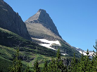
Mount Grinnell is a peak located in the heart of Glacier National Park in the U.S. state of Montana. Lying just east of the Continental Divide in the Many Glacier region of the park, the peak is flanked to the northwest by Swiftcurrent Glacier and to the south by Grinnell Glacier. Mount Grinnell is named after George Bird Grinnell. From the Many Glacier Hotel on Swiftcurrent Lake, the eastern arm of Mount Grinnell, known as Grinnell Point, hides the main summit.

Appistoki Peak is located in the Lewis Range, Glacier National Park in the U.S. state of Montana. Appistoki Peak, "was named by R. T. Evans, a topographer who worked on the early map of the park. It is reported that he inquired from his Indian guide what word the Blackfeet used for "looking over something," and the guide, misunderstanding the meaning of his question, gave him the name "Appistoki," for the Indian god who looks over everything and everyone." Appistoki Peak rises on the southeast shore of Two Medicine Lake and is a short distance north of Mount Henry.

Blackfoot Mountain is located in the Lewis Range, Glacier National Park in the U.S. state of Montana. To the north of Blackfoot Mountain lies Blackfoot Glacier, one of the largest glaciers in the park. The stagnant Pumpelly Glacier is located to the immediate east and northeast of the mountain.

Clements Mountain is located in the Lewis Range, Glacier National Park in the U.S. state of Montana. Clements Mountain rises to the west of Logan Pass and above the Hidden Lake Trail which leads to Hidden Lake just west of the continental divide. The peak was named after Walter M. Clements who had worked to set up a treaty between the Blackfeet and the U.S. Government for the purchase of tribal lands east of the continental divide which later became part of the park.

Divide Mountain is located in the Lewis Range, Glacier National Park in the U.S. state of Montana. Divide Mountain is located south of Saint Mary, Montana on the border of Glacier National Park and the Blackfeet Indian Reservation.

Grizzly Mountain is located in the Lewis Range, Glacier National Park in the U.S. state of Montana. Grizzly Mountain sits astride the Continental Divide in the Two Medicine region of Glacier National Park.

Mad Wolf Mountain is located in the Lewis Range, Glacier National Park in the U.S. state of Montana. Mad Wolf Mountain is just west of the Blackfeet Indian Reservation and rises abruptly above the Great Plains.

Mount Ellsworth is located in the Lewis Range, Glacier National Park in the U.S. state of Montana. Mount Ellsworth is in the southeastern section of Glacier National Park and can be seen from Two Medicine Lake and surrounding areas. Mount Ellsworth is named, "for "Billy" Ellsworth, an oldtimer who packed for the U. S. Geological Survey."

Mount Helen is located in the Lewis Range, Glacier National Park in the U.S. state of Montana. Mount Helen rises immediately to the northwest roughly 3,100 feet (940 m) above Upper Two Medicine Lake in the southeastern part of Glacier National Park. The Continental Divide of the Americas passes over the summit of Mount Helen.
Mount Henry is located in the Lewis Range, Glacier National Park in the U.S. state of Montana. Mount Henry is just south of Appistoki Peak in the Two Medicine region of the park.
Mount Kipp is located in the Lewis Range, Glacier National Park in the U.S. state of Montana. Immediately east of the summit lies the retreating Chaney Glacier. Mount Kipp is situated along the Continental Divide.

Mount Logan is located in the Lewis Range, Glacier National Park in the U.S. state of Montana. Logan Glacier is immediately north of Mount Logan and Red Eagle Glacier lies to the east. Mount Logan is situated along the Continental Divide.
Sherburne Peak is a 8,578-foot-high (2,615 m) mountain located in the Lewis Range, Glacier National Park in the U.S. state of Montana. Sherburne Peak has two summits: the higher one being in Glacier National Park and the lower summit is located within the Blackfeet Indian Reservation.

Sinopah Mountain is located in the Lewis Range, Glacier National Park in the U.S. state of Montana. Sinopah Mountain rises prominently to the west of Two Medicine Lake. Sinopah means, ""kit fox" in Blackfeet, (who) was the Indian wife of Hugh Monroe and daughter of Lone Walker, a powerful Blackfeet chief."
White Calf Mountain is located in the Lewis Range, Glacier National Park in the U.S. state of Montana. White Calf Mountain is south of Divide Mountain and just west of the Blackfeet Indian Reservation boundary.

Cloudcroft Peaks is located in the Lewis Range, Glacier National Park in the U.S. state of Montana.

Grinnell Point is located in the Lewis Range, Glacier National Park in the U.S. state of Montana. Grinnell Point is an oft-photographed mountain, situated conspicuously just west of Swiftcurrent Lake across from the Many Glacier Hotel. Grinnell Point is a subpeak of Mount Grinnell, which lies .21 mi (0.34 km) to the west-southwest and is oftentimes misidentified as Mount Grinnell since that summit cannot be seen from the roads in the Many Glacier region. Grinnell Point is named for George Bird Grinnell.

Altyn Peak is located in the Lewis Range, Glacier National Park in the U.S. state of Montana. Altyn Peak is situated just north of Swiftcurrent Lake and the Many Glacier Hotel and is easily seen from both locations. The peak is named after Dave Greenwood Altyn who was a financial backer of a local mine in the late 1800s; the mining town of Altyn was at the junction of Canyon Creek and Swiftcurrent Lake. The peak was known as Crow Feet Mountain after the last chief of the Blackfeet confederacy of tribes.


