New Boston, Iowa

Last updated

New Boston, Iowa
New boston iowa.jpg
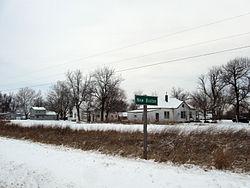
New Boston, Iowa, From route 218 facing northwest
USA Iowa location map.svg
Red pog.svg
New Boston
Location in Iowa
Usa edcp location map.svg
Red pog.svg
New Boston
Location in the United States
Coordinates: 40°33′38″N91°30′20″W / 40.56056°N 91.50556°W / 40.56056; -91.50556
Country United States
State Iowa
County Lee
Elevation
[1]
696 ft (212 m)
Time zone UTC-6 (Central (CST))
  Summer (DST) UTC-5 (CDT)
Area code 319
GNIS feature ID459469 [1]

New Boston is an unincorporated community in central Lee County, Iowa, United States. It lies in the southeast corner of Iowa, along U.S. Highway 218 and southwest of the city of Fort Madison, the county seat of Lee County. [2] New Boston is located nearby to the unincorporated communities of Argyle, Iowa and Charleston, Iowa. The community is part of the Fort Madison Keokuk, IA-MO Micropolitan Statistical Area.

History

Founded in the 1800s, New Boston's population was 56 in 1902, [3] and 26 in 1925. [4] The population was 100 in 1940. [5]

References

  1. 1 2 U.S. Geological Survey Geographic Names Information System: New Boston, Iowa
  2. Google Maps, https://maps.google.com
  3. Cram's Modern Atlas: The New Unrivaled New Census Edition. J. R. Gray & Company. 1902. pp. 203–207.
  4. Premier Atlas of the World: Containing Maps of All Countries of the World, with the Most Recent Boundary Decisions, and Maps of All the States, territories, and Possessions of the United States with Population Figures from the Latest Official Census Reports, Also Data of Interest Concerning International and Domestic Political Questions. Rand McNally & Company. 1925. p. 190.
  5. The Attorneys List. United States Fidelity and Guaranty Company, Attorney List Department. 1940. p. 307.