
The Eads Bridge is a combined road and railway bridge over the Mississippi River connecting the cities of St. Louis, Missouri, and East St. Louis, Illinois. It is located on the St. Louis riverfront between Laclede's Landing to the north, and the grounds of the Gateway Arch to the south. The bridge is named for its designer and builder, James Buchanan Eads. Work on the bridge began in 1867, and it was completed in 1874. The Eads Bridge was the first bridge across the Mississippi south of the Missouri River. Earlier bridges were located north of the Missouri, where the Mississippi is smaller. None of the earlier bridges survived, which means that the Eads Bridge is also the oldest bridge on the river.

The Great Falls of the Passaic River is a prominent waterfall, 77 feet (23 m) high, on the Passaic River in the city of Paterson in Passaic County, New Jersey. The falls and surrounding area are protected as part of the Paterson Great Falls National Historical Park, administered by the National Park Service. The Congress authorized its establishment in 2009.
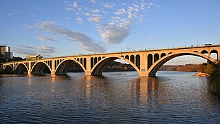
The Francis Scott Key Bridge, more commonly known as the Key Bridge, is a six-lane reinforced concrete arch bridge carrying U.S. Route 29 (US 29) across the Potomac River between the Rosslyn neighborhood of Arlington County, Virginia, and the Georgetown neighborhood of Washington, D.C. Completed in 1923, it is Washington's oldest surviving road bridge across the Potomac River.

Roebling's Delaware Aqueduct, also known as the Roebling Bridge, is the oldest existing wire suspension bridge in the United States. It runs 535 feet over the Delaware River, from Minisink Ford, New York, to Lackawaxen, Pennsylvania. Opened in 1849 as an aqueduct connecting two parts of the Delaware & Hudson Canal (D&H), it has since been converted to carry automotive traffic and pedestrians.

The Smithfield Street Bridge is a lenticular truss bridge crossing the Monongahela River in Pittsburgh, Pennsylvania, USA.

The Bollman Truss Railroad Bridge across the Little Patuxent River at Savage, Maryland, is one of the oldest standing iron railroad bridges in the United States and the sole surviving example of a revolutionary design in the history of American bridge engineering. The 160-foot (48.8 m) double-span was built in 1852 at an unknown location on the main line of the Baltimore and Ohio Railroad. It was moved 35 years later to its present location, where it replaced the very first Bollman bridge. Today, it carries the Savage Mill Trail.

The Carrollton Viaduct, located over the Gwynns Falls stream near Carroll Park in southwest Baltimore, Maryland, is the first stone masonry bridge for railroad use in the United States, built for the Baltimore and Ohio Railroad, founded 1827, and one of the world's oldest railroad bridges still in use for rail traffic. Construction began in 1828 and was completed in 1829. The bridge is named in honor of Charles Carroll of Carrollton (1737–1832), of Maryland, known for being the last surviving signer of the Declaration of Independence, the only Roman Catholic in the Second Continental Congress (1775–1781), and wealthiest man in the Thirteen Colonies of the time of the American Revolutionary War (1775–1783).

The Thomas Viaduct spans the Patapsco River and Patapsco Valley between Relay, Maryland and Elkridge, Maryland, USA. It was commissioned by the Baltimore and Ohio Railroad (B&O); built between July 4, 1833, and July 4, 1835; and named for Philip E. Thomas, the company's first president. Some claim it to be the world's oldest multiple arched stone railroad bridge. However, the Sankey Viaduct on the Liverpool and Manchester Railway was opened in 1830 and finally completed in 1833.

The Isaac Lee Patterson Bridge, also known as the Rogue River Bridge and the Isaac Lee Patterson Memorial Bridge, is a concrete arch bridge that spans the Rogue River in Curry County, Oregon. The bridge was constructed by the Mercer Fraser Company of Eureka, California. The bridge carries U.S. Route 101 across the river, near the point where the river empties into the Pacific Ocean, and connects the towns of Gold Beach and Wedderburn. A bridge with strong Art Deco influences, the Isaac Lee Patterson Bridge is a prominent example of the designs of the Oregon bridge designer and highway engineer Conde McCullough. It was designated a National Historic Civil Engineering Landmark by the American Society of Civil Engineers in 1982. It is part of a series of notable bridges designed by McCullough for the Oregon Coast Highway in the 1930s. It was placed on the National Register of Historic Places in 2005.

The Frankford Avenue Bridge, also known as the Pennypack Creek Bridge, the Pennypack Bridge, the Holmesburg Bridge, and the King's Highway Bridge, erected in 1697 in the Holmesburg section of Northeast Philadelphia, in the U.S. state of Pennsylvania, is the oldest surviving roadway bridge in the United States. The three-span, 73-foot-long (22 m) twin stone arch bridge carries Frankford Avenue, just north of Solly Avenue, over Pennypack Creek in Pennypack Park.
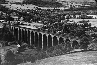
Starrucca Viaduct is a stone arch bridge that spans Starrucca Creek near Lanesboro, Pennsylvania, in the United States. Completed in 1848 at a cost of $320,000, it was at the time the world's largest stone railway viaduct and was thought to be the most expensive railway bridge as well. Still in use, the viaduct is listed on the National Register of Historic Places and is designated as a National Historic Civil Engineering Landmark.

Tunkhannock Creek Viaduct is a concrete deck arch bridge on the Nicholson Cutoff rail line segment of the Norfolk Southern Railway Sunbury Line that spans Tunkhannock Creek in Nicholson, Pennsylvania. Measuring 2,375 feet (724 m) long and towering 240 feet (73.15 m) when measured from the creek bed, it was the largest concrete structure in the world when completed in 1915 and still merited "the title of largest concrete bridge in America, if not the world" 50 years later.

Old Blenheim Bridge was a wooden covered bridge that spanned Schoharie Creek in North Blenheim, New York, United States. With an open span of 210 feet (64 m), it had the second longest span of any surviving single-span covered bridge in the world. The 1862 Bridgeport Covered Bridge in Nevada County, California, currently undergoing repairs due to 1986 flooding is longer overall at 233 feet (71 m) but is argued to have a 208 feet (63 m) clear span. The bridge, opened in 1855, was also one of the oldest of its type in the United States. It was destroyed by flooding resulting from Tropical Storm Irene in 2011. Rebuilding of the bridge commenced in 2017 and was completed in 2018.

The Kinzua Bridge or the Kinzua Viaduct was a railroad trestle that spanned Kinzua Creek in McKean County in the U.S. state of Pennsylvania. The bridge was 301 feet (92 m) tall and 2,052 feet (625 m) long. Most of its structure collapsed during a tornado in July 2003.

Hangar One is one of the world's largest freestanding structures, covering 8 acres at Moffett Field near Mountain View, California in the San Francisco Bay Area.

The Susitna River Bridge, also known as the Gold Creek Bridge, was the longest bridge span on the United States Government Railway in Alaska. The steel 504-ft. through-truss channel spans the Susitna River. It was completed in February, 1921. The crossing of the Susitna includes two 121-ft. combination Howe truss flanking spans and two 70-ft. combination pony Howe truss end spans, with 392 ft. of trestle at the southern approach and 28 ft. at the northern approach, making a total length of 1,322 ft. It is located 150 miles north of Anchorage, and 264 miles north of the terminus at Seward. The bridge was listed on the National Register of Historic Places in 1977.

The Zion – Mount Carmel Highway is a 25-mile (40 km) long road in Washington and Kane counties in southern Utah, United States, that is listed on the National Register of Historic Places and is a National Historic Civil Engineering Landmark.

Hudson County, New Jersey has historic districts which have been designated as such on a municipal, state, or federal level, or combination therof. Some are listed on New Jersey Register of Historic Places and are included on National Register of Historic Places listings in Hudson County, New Jersey. The following is intended to be a list of places which encompasses an area or group of buildings or structures.
Walter Mickle Smith, Sr. was a civil engineer who worked primarily on U.S. dams and waterway projects. He was a consulting engineer on the construction of the Panama Canal and Panama Canal Locks and later served as design engineer for the New York Board of Water Supply. He spent much of his career with the State of Illinois waterways division and was its chief engineer until his retirement in 1937. Several of his works built in the 1920s and 1930s as part of the Illinois Waterway project are listed on the National Register of Historic Places, including portions of the Brandon Road Lock and Dam, the Dresden Island Lock and Dam, the Lockport Lock and Power House, and the Marseilles Lock and Dam.

Rowell's Covered Bridge is a covered bridge in West Hopkinton, New Hampshire, which carries Rowell Bridge Road over the Contoocook River. The Long truss bridge was completed in 1853, and is one of New Hampshire's few surviving 19th-century covered bridges. It was listed on the National Register of Historic Places in 1976. It is named for Abram Rowell, an early resident of the area.


