
Union County is a county located in the U.S. state of Mississippi. It was formed in 1870 from Tippah and Pontotoc counties, and in 1874 a portion of Lee County was added. As of the 2020 census, the population was 27,777. Its county seat is New Albany. According to most sources, the county received its name by being a union of pieces of several large counties, like other Union counties in other states. However, other sources say that the name was meant to mark the re-union of Mississippi and the other Confederate states after the Civil War.
Tishomingo County is a county located in the northeastern corner of the U.S. state of Mississippi. As of the 2020 census, the population was 18,850. Its county seat is Iuka.

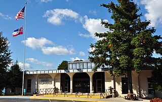
Benton County is a county located in the U.S. state of Mississippi. As of the 2020 census, the population was 7,646. Its county seat is Ashland.

Wood River is a city in Madison County, Illinois. The population was 10,464 as of the 2020 census.

Morgan City is a small city in St. Mary and lower St. Martin parishes in the U.S. State of Louisiana in the Acadiana region. The population was 12,404 at the 2010 census. Known for being “right in the middle of everywhere”, Morgan City is located 68 miles (109 km) southeast of Lafayette, 64 miles (103 km) south of Baton Rouge, and 86 miles (138 km) west of New Orleans

Columbus is a city in and the county seat of Lowndes County, on the eastern border of Mississippi, United States, located primarily east, but also north and northeast of the Tombigbee River, which is also part of the Tennessee-Tombigbee Waterway. It is approximately 146 miles (235 km) northeast of Jackson, 92 miles (148 km) north of Meridian, 63 miles (101 km) south of Tupelo, 60 miles (97 km) northwest of Tuscaloosa, Alabama, and 120 miles (193 km) west of Birmingham, Alabama.

Picayune is the largest city in Pearl River County, Mississippi, United States. The population was 10,878 at the 2010 census. The city is located approximately 45 miles (72 km) from New Orleans, Hattiesburg, and Gulfport–Biloxi. The Stennis Space Center is 10 miles (16 km) away. Picayune is part of the New Orleans–Metairie–Hammond combined statistical area.

Southaven is a city in DeSoto County, Mississippi, United States. It is a principal city in Greater Memphis. The 2020 census reported a population of 54,648, making it the third-largest city in Mississippi and the second-most populous suburb of Memphis. Southaven is traversed north to south by the I-55/I-69 freeway. The city's name derives from the fact that Southaven is located south of Whitehaven, a neighborhood in Memphis.
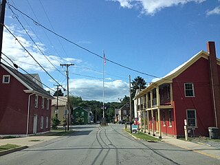
Harmony is a borough in Butler County, Pennsylvania, United States. The population was 890 at the 2010 census. It is located approximately 30 miles (48 km) north of Pittsburgh.

U.S. Route 82 is an east–west United States highway in the Southern United States. Created on July 1, 1931 across central Mississippi and southern Arkansas, US 82 eventually became a 1,625-mile-long (2,615 km) route extending from the White Sands of New Mexico to Georgia's Atlantic coast.

The Tombigbee River is a tributary of the Mobile River, approximately 200 mi (325 km) long, in the U.S. states of Mississippi and Alabama. Together with the Alabama, it merges to form the short Mobile River before the latter empties into Mobile Bay on the Gulf of Mexico. The Tombigbee watershed encompasses much of the rural coastal plain of western Alabama and northeastern Mississippi, flowing generally southward. The river provides one of the principal routes of commercial navigation in the southern United States, as it is navigable along much of its length through locks and connected in its upper reaches to the Tennessee River via the Tennessee-Tombigbee Waterway.

Perdido River, historically Rio Perdido (1763), is a 65.4-mile-long (105.3 km) river in the U.S. states of Alabama and Florida; the Perdido, a designated Outstanding Florida Waters river, forms part of the boundary between the two states along nearly its entire length and drains into the Gulf of Mexico. During the early 19th century it played a central role in a series of rotating boundary changes and disputes among France, Spain, Great Britain, and the United States.
Nesbit is an unincorporated community in DeSoto County, Mississippi, United States.
Tralake is an unincorporated community located in Washington County, Mississippi. Tralake is approximately 5.8 miles (9.3 km) west-southwest of Kinlock, approximately 5.6 miles (9.0 km) west-southwest of Tribbett and approximately 4.9 miles (7.9 km) east of Arcola along Mississippi Highway 438.
Enid is an unincorporated community located in Tallahatchie County, Mississippi, United States. Enid is located near U.S. Highway 51 approximately 7 miles (11 km) north of Oakland, Mississippi and approximately 9 miles (14 km) south of Pope, Mississippi.

Shellmound is an unincorporated community located in Leflore County, Mississippi, United States, located approximately 6 miles (9.7 km) north of Greenwood and approximately 6 miles (9.7 km) southeast of Schlater near U.S. Highway 49E.
Stephenville is an unincorporated community located in Sunflower County, Mississippi, United States. Stephenville is approximately 6 miles (9.7 km) north of Indianola and approximately 2 miles (3.2 km) northwest of Boyer along Mississippi Highway 448.

O'Reilly is an unincorporated community located in Bolivar County, Mississippi, United States, along U.S. Route 61. O'Reilly is approximately 3 miles (4.8 km) south of Boyle and approximately 6 miles (9.7 km) north of Shaw. O'Reilly is located on the former Yazoo and Mississippi Valley Railroad.

Mileston is an unincorporated community located in Holmes County, Mississippi. Mileston is located on U.S. Highway 49E and Highway 12, approximately 6 miles (9.7 km) south of Tchula, approximately 4 miles (6.4 km) north of Thornton and approximately 3 miles (4.8 km) southeast of Marcella.

Ingomar is an unincorporated community located near Mississippi Highway 15 in Union County, Mississippi.


