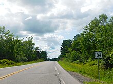
New York State Route 812 (NY 812) is a state highway in the North Country of New York in the United States. The southern terminus of the route is at an intersection with NY 12 and NY 26 in the Lewis County village of Lowville. Its northern terminus is at the Canada–United States border in Ogdensburg, where it crosses the Ogdensburg–Prescott International Bridge and connects to Highway 16 in Ontario. While most of NY 812 passes through rural areas of the North Country, the route also serves several villages and small communities. The GPS services company Geotab has named it the quietest highway in New York due to its low traffic counts.
New York State Route 75 (NY 75) is a north–south state highway in Erie County, New York, in the United States. It extends for 20.85 miles (33.55 km) from an intersection with NY 39 in the Collins hamlet of Collins Center to an interchange with NY 5 in the town of Hamburg. The route passes through the village of Hamburg, which serves as the northern terminus of a 2-mile (3.2 km) overlap between U.S. Route 62 (US 62) and NY 75. Past Hamburg, NY 75 connects to the New York State Thruway northwest of the village before ending a short distance from Lake Erie. The portion of NY 75 south of Hamburg is a two-lane rural highway; in contrast, the section north of the village is four lanes wide and serves commercial and residential areas.
New York State Route 126 (NY 126) is a 28.56-mile-long (45.96 km) state highway in the North Country of New York in the United States. It proceeds in a roughly northwest to southeast direction between NY 12 at the eastern city line of Watertown in central Jefferson County and NY 812 in the village of Croghan in northern Lewis County. In between, NY 126 serves the adjacent villages of West Carthage and Carthage, where the route has overlaps with NY 3 and NY 26. Most of the route passes through rural areas, and the portion southeast of Carthage parallels either the Black River or a tributary of it.

New York State Route 137 (NY 137) is a 5.51-mile (8.87 km) long state highway in Westchester County, New York, in the United States. The route is a continuation of Connecticut's Route 137, which links NY 137 to Stamford, Connecticut. NY 137 goes through the hamlet of Pound Ridge and ends at NY 121 north of the hamlet of Bedford, locally known as Bedford Village.

New York State Route 83 (NY 83) is a state route located entirely in Chautauqua County, New York in the United States. It extends from an intersection with U.S. Route 62 (US 62) in the hamlet of Conewango Valley to NY 60 in the hamlet of Laona, near Fredonia. Along the way, NY 83 intersects with NY 322 at Balcom Corners and serves the hamlet of Cherry Creek.

New York State Route 246 (NY 246) is a 10.44-mile-long (16.80 km) north–south state highway located in western New York in the United States. All but 0.09 miles (0.14 km) of the route are located in Wyoming County; the northernmost intersection on the highway is in Genesee County instead. The southern terminus of the route is at an intersection with NY 39 in the village of Perry and its northern terminus is at a junction with NY 63 in the town of Pavilion. NY 246 intersects U.S. Route 20A (US 20A) north of Perry village and also passes through the town of Covington.

New York State Route 221 (NY 221) is a state highway in Cortland County, New York, in the United States. Its western terminus is at an intersection with NY 38 in the town of Harford. The eastern terminus is at a junction with NY 26 and NY 41 in the town of Willet. Near its western end, NY 221 intersects New York State Route 200. Together, NY 200 and NY 221 form a loop route off NY 38 between the hamlets of Harford and Harford Mills within the town of Harford. NY 221 originally followed modern NY 200 and ended at U.S. Route 11 (US 11) in Marathon when it was assigned as part of the 1930 renumbering of state highways in New York. It was extended to its present length by the following year and realigned to serve Harford later in the decade. NY 200 was assigned in the 1940s.
New York State Route 392 (NY 392) is an east–west state highway in the Southern Tier region of New York in the United States. The western terminus of the route is at an intersection with the concurrency of NY 13 and NY 38 in the village of Dryden in Tompkins County. Its eastern terminus is at a junction with U.S. Route 11 (US 11) in the hamlet of Messengerville within the Cortland County town of Virgil. NY 392 passes through the hamlet of Virgil, where it intersects NY 215.

New York State Route 695 (NY 695) is a short state highway located west of Syracuse in the towns of Camillus and Geddes in Onondaga County, New York. The number of the highway was derived from the two highways that NY 695 links, Interstate 690 (I-690) and NY 5. The northern end of the highway passes by the New York State Fairgrounds.

New York State Route 89 (NY 89) is a north–south state highway in central New York in the United States. It extends for 62.35 miles (100.34 km) from an intersection with NY 13, NY 34, and NY 96 in the Tompkins County city of Ithaca to an interchange with NY 104 in the Wayne County town of Wolcott. The route spans a total of three counties, connecting the heart of the Finger Lakes Region to a point 6 miles (10 km) south of Lake Ontario. Along the way, NY 89 intersects two regionally important highways: the conjoined routes of U.S. Route 20 (US 20) and NY 5 in Seneca Falls and NY 31 in Savannah. NY 89 runs along the western edge of Cayuga Lake from Ithaca to Seneca Falls.
New York State Route 255 (NY 255) was a 5.8-mile-long (9.3 km) state highway located in Livingston County, New York, in the United States. The southern terminus of the route was at an intersection with NY 256 south of the community of Scottsburg in Sparta. Its northern terminus was at a junction with NY 15 in Conesus. NY 255, known locally as Stagecoach Road, was assigned in 1930 and maintained by Livingston County from 1983 onward as County Route 71 (CR 71). The concurrent state highway designation was removed in 1995.

New York State Route 37 (NY 37) is a state highway in the North Country of New York in the United States, extending for 127.40 miles (205.03 km) on a west–east axis. The western terminus of the route is at an intersection with U.S. Route 11 (US 11) in Pamelia, Jefferson County. Its eastern terminus is at a junction with US 11, NY 11B, and NY 30 in Malone, Franklin County. In between the termini, NY 37 passes through Ogdensburg and Massena. It is a two-lane, nondivided, full access roadway for most of its entire length, except for portions between Massena and western Franklin County, where the route widens to a four-lane divided highway.

New York State Route 245 (NY 245) is a state highway in the Finger Lakes region of New York in the United States. The southern terminus of the route is at NY 21 in Naples. The northern terminus is at NY 5, U.S. Route 20 and NY 14A west of Geneva. From Geneva to Naples, NY 245 traverses the land from the north end of Seneca Lake to the south end of Canandaigua Lake in roughly a northeast to southwest direction.
New York State Route 351 (NY 351) is a north–south state highway in central Rensselaer County, New York, in the United States. It extends for 8.16 miles (13.13 km) from an intersection with NY 43 in the Sand Lake hamlet of West Sand Lake to a junction with NY 2 in the Brunswick hamlet of Cropseyville. The portion of NY 351 north of the hamlet of Poestenkill was originally designated as New York State Route 153 in the 1930s. This designation was removed in the 1940s, and the West Sand Lake–Cropseyville roadway became County Route 77 (CR 77) sometime afterward. On April 1, 1980, all of CR 77 was transferred to the state of New York, at which time it was redesignated as NY 351 by the New York State Department of Transportation (NYSDOT).

New York State Route 161 (NY 161) is an east–west state highway located in eastern Montgomery County, New York, in the United States. It extends for just over 7 miles (11 km) from an intersection with NY 30A in the town of Glen to a junction with NY 30 in the town of Florida. The route is a two-lane highway known as Mill Point Road, named for a small hamlet situated near NY 161's midpoint. At Mill Point, the road crosses Schoharie Creek. NY 161 was assigned as part of the 1930 renumbering of state highways in New York and has not been altered since.
New York State Route 122 (NY 122) is a 10.26-mile-long (16.51 km) east–west state highway in northern Franklin County, New York, United States. The western terminus of the route is at an intersection with NY 37 in the town of Westville. Its eastern terminus is at a junction with U.S. Route 11 (US 11) in the town of Burke. Near its midpoint, NY 122 has a short overlap with NY 30 in the town of Constable. NY 122 serves as a northerly bypass of the village of Malone, situated 6 miles (10 km) to the south.

New York State Route 68 (NY 68) is an east–west state highway located entirely within St. Lawrence County in the North Country of New York in the United States. The western terminus is at an intersection with NY 37 in Oswegatchie, just west of the Ogdensburg city limits. The eastern terminus is at a junction with NY 56 in the hamlet of Colton within the town of Colton. Along the way, NY 68 passes through the village of Canton, where it overlaps with U.S. Route 11 (US 11) through the village.

New York State Route 58 (NY 58) is a north–south state highway located in St. Lawrence County, New York, in the United States. The highway runs in a northwest to southeast direction as it traverses the county. The southern terminus of the route is at a junction with NY 3 in the hamlet of Fine within the town of the same name. Its northern terminus is at an intersection with NY 37 near the St. Lawrence River in the hamlet of Morristown. Part of NY 58 passes through the Adirondack Mountains.

New York State Route 358 (NY 358) was a north–south state highway in Erie County, New York, in the United States. The southern terminus of the route was at an intersection with U.S. Route 20A (US 20A) in the hamlet of Wales Center within the town of Wales. Its northern terminus was at a junction with US 20 in the town of Alden. NY 358 mostly followed Two Rod Road; however, it was also routed on parts of Liberia and Four Rod roads.

New York State Route 285 (NY 285) was a state highway in Oneida County, New York, in the United States. The southern terminus of the 6.87-mile (11.06 km) route was at an intersection with NY 69 west of the hamlet of Taberg in the town of Annsville. Its northern terminus was in the community of Thompson Corners, where it ended at a junction with County Route 67A (CR 67A) and CR 70. NY 285 was little more than a connector between NY 69 and Thompson Corners, as it did not pass through any other areas of interest.