De Kalb, New York

Last updated

DeKalb, New York
De Kalb NY Locator Map.png
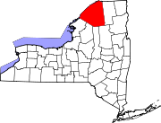
Map highlighting De Kalb's location within St. Lawrence County.
USA New York location map.svg
Red pog.svg
DeKalb
Location within the state of New York
Coordinates: 44°28′18″N75°21′10″W / 44.47167°N 75.35278°W / 44.47167; -75.35278
CountryUnited States
State New York
County St. Lawrence
Area
[1]
  Total83.21 sq mi (215.50 km2)
  Land82.52 sq mi (213.73 km2)
  Water0.68 sq mi (1.77 km2)
Elevation
302 ft (92 m)
Population
 (2010)
  Total2,434
  Estimate 
(2016) [2]
2,378
  Density28.82/sq mi (11.13/km2)
Time zone UTC-5 (Eastern (EST))
  Summer (DST) UTC-4 (EDT)
FIPS code 36-20038
GNIS feature ID0978893

DeKalb is a town in St. Lawrence County, New York, United States. The population was 2,434 at the 2010 census. The town is named after American general Baron de Kalb, a German officer serving under George Washington. [3]

Contents

The Town of DeKalb is in the southwest part of the county and is southwest of the Village of Canton.

History

Settlement began in June 1803 when the first settlement party arrived, led by Judge William Cooper of Cooperstown, New York.

The town was organized in 1806 from the town of Oswegatchie. DeKalb was one of the original ten towns of the county. In 1825, the part of DeKalb north west of Beaver Creek was taken to be part of the Town of DePeyster. In 1830, the Southeastern corner of DeKalb was made part of the Town of Hermon.

St. Regis and St. François Native Americans used to frequently visit the settlement on hunting expeditions. [3]

Geography

According to the United States Census Bureau, the town has a total area of 83.2 square miles (215 km2), of which 82.5 square miles (214 km2) is land and 0.7 square miles (1.8 km2) (0.82%) is water.

The Oswegatchie River flows through the western part of the town. Beaver Creek defines the northwestern town line.

U.S. Route 11 is a northeast–southwest highway in the south part of the town. New York State Route 812 intersects US-11 south of DeKalb village.

Demographics

Historical population
CensusPop.Note
1820 709
1830 1,06049.5%
1840 1,53144.4%
1850 2,38956.0%
1860 3,18233.2%
1870 3,116−2.1%
1880 3,027−2.9%
1890 2,840−6.2%
1900 2,723−4.1%
1910 2,516−7.6%
1920 2,419−3.9%
1930 2,346−3.0%
1940 2,116−9.8%
1950 2,063−2.5%
1960 2,1373.6%
1970 2,062−3.5%
1980 2,1303.3%
1990 2,1531.1%
2000 2,2132.8%
2010 2,43410.0%
2016 (est.)2,378 [2] −2.3%
U.S. Decennial Census [4]

As of the census [5] of 2000, there were 2,213 people, 792 households, and 582 families residing in the town. The population density was 26.8 inhabitants per square mile (10.3/km2). There were 889 housing units at an average density of 10.8 units per square mile (4.2 units/km2). The racial makeup of the town was 98.19% White, 0.27% African American, 0.27% Native American, 0.09% Asian, 0.32% from other races, and 0.86% from two or more races. Hispanic or Latino of any race were 0.27% of the population.

There were 792 households, out of which 37.4% had children under the age of 18 living with them, 57.4% were married couples living together, 9.6% had a female householder with no husband present, and 26.4% were non-families. 21.1% of all households were made up of individuals, and 8.2% had someone living alone who was 65 years of age or older. The average household size was 2.79 and the average family size was 3.23.

In the town, the population was spread out, with 30.2% under the age of 18, 8.5% from 18 to 24, 27.5% from 25 to 44, 23.4% from 45 to 64, and 10.3% who were 65 years of age or older. The median age was 34 years. For every 100 females, there were 101.0 males. For every 100 females age 18 and over, there were 102.1 males.

The median income for a household in the town was $33,173, and the median income for a family was $37,463. Males had a median income of $29,000 versus $23,050 for females. The per capita income for the town was $13,742. About 11.4% of families and 15.7% of the population were below the poverty line, including 23.2% of those under age 18 and 9.8% of those age 65 or over.

Notable people

Communities and locations in DeKalb

Related Research Articles

Diana is a town in Lewis County, New York, United States. The population was 1,709 at the 2010 census. The town is on the northeastern border of the county and is located northeast of Watertown. The northwestern section of Diana is in the Fort Drum military reservation.

Harrisville is a hamlet and former village in Lewis County, New York, United States. The community is now a census-designated place. The population was 628 at the 2010 census.

New Bremen is a town in Lewis County, New York, United States. The population was 2,706 at the 2010 census. The town is named after the German city of Bremen.

<span class="mw-page-title-main">Volney, New York</span> Town in New York, United States

Volney is a town in Oswego County, New York, United States. The population was 5,926 at the 2010 census. The town was named after a French author, Constantin François de Chassebœuf, comte de Volney, who toured the area in 1808.

<span class="mw-page-title-main">Clifton, New York</span> Town in New York, United States

Clifton is a town in St. Lawrence County, New York, United States. The population was 675 at the 2020 census. The town takes its name from a mining company.

<span class="mw-page-title-main">De Peyster, New York</span> Town in New York, United States

DePeyster is a town in St. Lawrence County, New York, United States. The population was 998 at the 2010 census. The name is taken from that of one of the land owners of the region, Frederic de Peyster, grandfather of John Watts de Peyster.

<span class="mw-page-title-main">Fine, New York</span> Town in New York, United States

Fine is a town in St. Lawrence County, New York, United States. The population was 1,512 at the 2010 census. The town is named after Judge John Fine, a businessman involved in settling the town.

<span class="mw-page-title-main">Fowler, New York</span> Town in New York, United States

Fowler is a town in St. Lawrence County, New York, United States. The population was 2,202 at the 2010 census.

<span class="mw-page-title-main">Heuvelton, New York</span> Village in New York, United States

Heuvelton is a small rural, incorporated, village located in St. Lawrence County in the state of New York, United States. It is approximately six miles (9.7 km) southeast of the city of Ogdensburg, in the Town of Oswegatchie. It is the only village in the town. Route 812 bisects the village, and is named State Street within the village boundaries. As of the 2010 census, the village had a total population of 714.

<span class="mw-page-title-main">Oswegatchie, New York</span> Town in New York, United States

Oswegatchie is a town in St. Lawrence County, New York, United States. The population was 4,397 at the 2010 census. The name reportedly means "Black Water". It is on the northern border of the county and is adjacent to the city of Ogdensburg.

<span class="mw-page-title-main">Pitcairn, New York</span> Town in New York, United States

Pitcairn is a town in St. Lawrence County, New York, United States. The population was 846 at the 2010 census. The name is from that of Joseph Pitcairn, an early landowner and diplomat.

Richville is a village in St. Lawrence County, New York, United States. The population was 323 at the 2010 census. The name is taken from an early settler.

<span class="mw-page-title-main">Rossie, New York</span> Town in New York, United States

Rossie is a town in St. Lawrence County, New York, United States. The population was 877 at the 2010 census. The town is named after the sister of an early land owner.

Antwerp is a town in Jefferson County, New York, United States. The population was 1,846 at the 2010 census. The town is named after Antwerp, Belgium, the home of the early investors in the town, who had organized under the name of the Antwerp Company.

<span class="mw-page-title-main">Croghan, New York</span> Town in New York, United States

Croghan is a town in Lewis County, New York, United States. The population was 3,093 at the 2010 census. The town is in the northern part of the county and located northeast of the county seat, Lowville. The town contains a village also named Croghan, a small part of which is located in the adjacent town of New Bremen. Both the village and town are locally pronounced \Krō-gun\.

Edwards is a hamlet in St. Lawrence County, New York, United States. The population was 439 at the 2010 census. It was an incorporated village until dissolution in 2012.

<span class="mw-page-title-main">Edwards, New York</span> Town in New York, United States

Edwards is a town in St. Lawrence County, New York, United States. The population was 1,156 at the 2010 census. The village is named after Edward McCormack, brother of the founder.

Gouverneur is a village in St. Lawrence County, New York, United States. The population was 3,949 at the 2010 census. The village is named after Gouverneur Morris, one of the authors of the Constitution of the United States, as well as a prominent landowner and part-time resident of the area.

<span class="mw-page-title-main">Gouverneur, New York</span> Town in New York, United States

Gouverneur is a town in St. Lawrence County, New York, United States. As of the 2020 census, the population was 6,551. That was down from 7,085 in 2010. The town is named after statesman and landowner Gouverneur Morris.

<span class="mw-page-title-main">Hermon, New York</span> Town in New York, United States

Hermon is a town in St. Lawrence County, New York, United States. The population was 1,108 at the 2010 census. Hermon is named after Mount Hermon in Israel, which is the name corresponding to Mount Jabal al-Sheikh in Syria. The town contains a hamlet also called Hermon, and is in the south-central part of the county, southwest of Canton.

References

  1. "2016 U.S. Gazetteer Files". United States Census Bureau. Retrieved July 5, 2017.
  2. 1 2 "Population and Housing Unit Estimates" . Retrieved June 9, 2017.
  3. 1 2 Hough, Franklin B. (1853) "A history of St. Lawrence and Franklin counties, New York: from the earliest period to the present time"
  4. "Census of Population and Housing". Census.gov. Retrieved June 4, 2015.
  5. "U.S. Census website". United States Census Bureau . Retrieved January 31, 2008.
  6. Davis, Henry Blaine Jr. (1998). Generals in Khaki. Raleigh, NC: Pentland Press. p. 361. ISBN   9781571970886.
  7. "Bioguide Search". bioguide.congress.gov. Retrieved January 9, 2024.

44°29′56″N75°20′34″W / 44.49889°N 75.34278°W / 44.49889; -75.34278