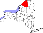
Richville, New York

Last updated
Richville, New York
USA New York location map.svg
Red pog.svg
Richville, New York
Location within the state of New York
Coordinates: 44°24′46″N75°23′37″W / 44.41278°N 75.39361°W / 44.41278; -75.39361
CountryUnited States
State New York
County St. Lawrence
Area
[1]
  Total0.74 sq mi (1.91 km2)
  Land0.74 sq mi (1.91 km2)
  Water0.00 sq mi (0.00 km2)
Elevation
407 ft (124 m)
Population
 (2020)
  Total234
  Density317.07/sq mi (122.37/km2)
Time zone UTC-5 (Eastern (EST))
  Summer (DST) UTC-4 (EDT)
FIPS code 36-61621
GNIS feature ID0976888

Richville is a village in St. Lawrence County, New York, United States. The population was 323 at the 2010 census. The name is taken from an early settler.

Contents

The Village of Richville is in the southwestern corner of the Town of De Kalb and is southwest of the Village of Canton.

Geography

Richville is located at 44°24′46″N75°23′37″W / 44.41278°N 75.39361°W / 44.41278; -75.39361 (44.412874, -75.393608). [2]

According to the United States Census Bureau, the village has a total area of 0.7 square miles (1.8 km2), all land.

Richville is located on U.S. Route 11, which is conjoined with New York State Route 812 in the village.

The Oswegatchie River flows northward past the western side of the village.

Demographics

Historical population
CensusPop.Note
1880 339
1890 336−0.9%
1900 331−1.5%
1910 307−7.3%
1920 302−1.6%
1930 3020.0%
1940 274−9.3%
1950 254−7.3%
1960 29215.0%
1970 33414.4%
1980 3360.6%
1990 311−7.4%
2000 274−11.9%
2010 32317.9%
2020 234−27.6%
U.S. Decennial Census [3]

As of the census [4] of 2000, there were 274 people, 109 households, and 80 families residing in the village. The population density was 371.4 inhabitants per square mile (143.4/km2). There were 120 housing units at an average density of 162.7 units per square mile (62.8 units/km2). The racial makeup of the village was 98.91% White, 0.73% African American and 0.36% Native American.

There were 109 households, out of which 33.9% had children under the age of 18 living with them, 56.9% were married couples living together, 10.1% had a female householder with no husband present, and 25.7% were non-families. 20.2% of all households were made up of individuals, and 5.5% had someone living alone who was 65 years of age or older. The average household size was 2.51 and the average family size was 2.89.

In the village, the population was spread out, with 23.7% under the age of 18, 9.5% from 18 to 24, 32.8% from 25 to 44, 21.5% from 45 to 64, and 12.4% who were 65 years of age or older. The median age was 37 years. For every 100 females, there were 101.5 males. For every 100 females age 18 and over, there were 99.0 males.

The median income for a household in the village was $35,455, and the median income for a family was $39,375. Males had a median income of $35,938 versus $21,500 for females. The per capita income for the village was $16,040. About 8.6% of families and 7.4% of the population were below the poverty line, including 4.4% of those under the age of eighteen and 8.8% of those 65 or over.

Related Research Articles

<span class="mw-page-title-main">Waldo, Alabama</span> Town in Alabama, United States

Waldo is a town in Talladega County, Alabama, United States. It incorporated in 1972. At the 2020 census, the population was 258.

<span class="mw-page-title-main">Rock City, Illinois</span> Village in Illinois, United States

Rock City is a village in Stephenson County, Illinois. The population was 315 at the 2010 census, up from 313 in 2000.

<span class="mw-page-title-main">Michiana, Michigan</span> Village in Michigan, United States

Michiana is a village in New Buffalo Township, Berrien County in the extreme southwest corner of the U.S. state of Michigan. The population was 182 at the 2010 census.

Wheeler Township is a civil township of Gratiot County in the U.S. state of Michigan. As of the 2000 census, the township population was 2,785. Inside the township is the Village of Breckenridge.

Denmark Township is a civil township of Tuscola County in the U.S. state of Michigan. The population was 3,068 at the 2010 Census.

<span class="mw-page-title-main">Richville, Minnesota</span> City in Minnesota, United States

Richville is a city in Otter Tail County, Minnesota, United States. The population was 77 as of the 2020 census.

<span class="mw-page-title-main">River Bend, Missouri</span> Village in Missouri, United States

River Bend is a village in Jackson County, Missouri, United States. The population was 3 at the 2020 census. It is the only part of Jackson County that lies north of the Missouri River. In 1951, the Missouri River was relocated to a new channel, creating River Bend,. The county line still follows the original riverbed. It is part of the Kansas City metropolitan area. The mayor is Alex Dockler.

<span class="mw-page-title-main">Evergreen, Missouri</span> Village in Missouri, United States

Evergreen is a village in Laclede County, Missouri, United States. The population was 28 at the 2010 census. It was named Twin Bridges at the 2000 census.

<span class="mw-page-title-main">Blodgett, Missouri</span> Village in Missouri, United States

Blodgett is a village in Scott County, Missouri, United States. The population was 213 at the 2010 census.

<span class="mw-page-title-main">Roscoe, Missouri</span> Village in Missouri, United States

Roscoe is a village in St. Clair County, Missouri, United States. The population was 89 at the 2020 census.

<span class="mw-page-title-main">Linwood, Nebraska</span> Village in Nebraska, United States

Linwood is a village in Butler County, Nebraska, United States. The population was 88 at the 2010 census.

<span class="mw-page-title-main">Ritchey, Missouri</span> Town in Missouri, United States

Ritchey is a village in Newton County, Missouri, United States. The population was 82 at the 2010 census. It is part of the Joplin, Missouri Metropolitan Statistical Area.

<span class="mw-page-title-main">De Kalb, New York</span> Town in New York, United States

DeKalb is a town in St. Lawrence County, New York, United States. The population was 2,434 at the 2010 census. The town is named after American general Baron de Kalb, a German officer serving under George Washington.

<span class="mw-page-title-main">Minster, Ohio</span> Village in Ohio, United States

Minster is a village in Auglaize and Shelby counties, in the U.S. state of Ohio. The population was 3,046 at the 2020 census. It is included in the Wapakoneta, Ohio Micropolitan Statistical Area. It is adjacent to the village of New Bremen to the north.

<span class="mw-page-title-main">South Middletown, Ohio</span> Former CDP in Ohio, United States

South Middletown is a former census-designated place (CDP) in Lemon Township, Butler County, Ohio, United States. The population was 264 at the 2000 census. The area of South Middletown is now within the city limits of Middletown.

<span class="mw-page-title-main">Berkey, Ohio</span> Village in Ohio, United States

Berkey is a village in Lucas County, Ohio, United States. The population was 237 at the 2010 census.

<span class="mw-page-title-main">New Lebanon, Ohio</span> Village in Ohio, United States

New Lebanon is a village in Montgomery County, Ohio, United States. The population was 3,796 at the 2020 census. It is part of the Dayton Metropolitan Statistical Area.

<span class="mw-page-title-main">Helena, Ohio</span> Village in Ohio, United States

Helena is a village in Sandusky County, Ohio, United States. The population was 224 at the 2010 census.

<span class="mw-page-title-main">Clearview, West Virginia</span> Village in West Virginia, United States

Clearview is a village in Ohio County, West Virginia, United States. It is part of the Wheeling, West Virginia Metropolitan Statistical Area. The population was 565 at the 2010 census.

<span class="mw-page-title-main">Ironton, Wisconsin</span> Village in Wisconsin, United States

Ironton is a village in Sauk County, Wisconsin, United States, along the Little Baraboo River. The population was 253 at the 2010 census. The village is located within the Town of Ironton.

References

  1. "ArcGIS REST Services Directory". United States Census Bureau. Retrieved September 20, 2022.
  2. "US Gazetteer files: 2010, 2000, and 1990". United States Census Bureau. 2011-02-12. Retrieved 2011-04-23.
  3. "Census of Population and Housing". Census.gov. Retrieved June 4, 2015.
  4. "U.S. Census website". United States Census Bureau . Retrieved 2008-01-31.