Edwards (CDP), New York

Last updated
Edwards, New York
Hamlet and CDP
USA New York location map.svg
Red pog.svg
Edwards, New York
Location within the state of New York
Coordinates: 44°19′25″N75°15′11″W / 44.32361°N 75.25306°W / 44.32361; -75.25306
CountryUnited States
State New York
County St. Lawrence
Town Edwards
Settled1814
Village dissolutionDecember 31, 2012
Area
[1]
  Total0.96 sq mi (2.49 km2)
  Land0.93 sq mi (2.40 km2)
  Water0.04 sq mi (0.10 km2)
Elevation
669 ft (204 m)
Population
 (2020)
  Total361
  Density390.27/sq mi (150.70/km2)
Time zone UTC-5 (Eastern (EST))
  Summer (DST) UTC-4 (EDT)
FIPS code 36-23635
GNIS feature ID2761297

Edwards is a hamlet (and census-designated place) in St. Lawrence County, New York, United States. The population was 439 at the 2010 census. It was an incorporated village until dissolution in 2012.

Contents

The hamlet is in the northeast corner of the Town of Edwards. Both the former village and surrounding town are near the south county line.

History

The village was originally settled on a river island, but expanded onto the mainland to take advantage of the "Russell Turnpike," a military road. The first structure, a grist mill, was erected in the future village in 1814, giving the future village its first name "Sheads Mill."

A destructive fire in 1894 destroyed much of the village.

On Tuesday, March 15, 2011, village voters decided to dissolve the village into the surrounding town by a vote of 55 to 9 in favor. The village was dissolved on December 31, 2012, and on January 1, 2013, the Town of Edwards assumed responsibility for the former village. [2]

Geography

Edwards is located at 44°19′25″N75°15′10″W / 44.32361°N 75.25278°W / 44.32361; -75.25278 (44.323659, -75.252926). [3]

According to the United States Census Bureau, the village has a total area of 1.0 square mile (2.6 km2), of which 1.0 square mile (2.5 km2) is land and 1.01% is water.

The village is by the junction of County Roads 19 and 24, north of New York State Route 58.

The Oswegatchie River flows westward past the village.

Demographics

Historical population
CensusPop.Note
2020 361
U.S. Decennial Census [4]

As of the census [5] of 2000, there were 465 people, 177 households, and 118 families residing in the village. The population density was 477.2 inhabitants per square mile (184.2/km2). There were 192 housing units at an average density of 197.0 per square mile (76.1/km2). The racial makeup of the village was 96.77% White, 0.43% Black or African American, 0.65% Native American, 0.22% from other races, and 1.94% from two or more races. Hispanic or Latino of any race were 1.29% of the population.

There were 177 households, out of which 35.6% had children under the age of 18 living with them, 50.3% were married couples living together, 13.0% had a female householder with no husband present, and 32.8% were non-families. 27.1% of all households were made up of individuals, and 18.1% had someone living alone who was 65 years of age or older. The average household size was 2.63 and the average family size was 3.20.

In the village, the population was spread out, with 29.5% under the age of 18, 7.3% from 18 to 24, 27.5% from 25 to 44, 19.1% from 45 to 64, and 16.6% who were 65 years of age or older. The median age was 35 years. For every 100 females, there were 90.6 males. For every 100 females age 18 and over, there were 86.4 males.

The median income for a household in the village was $30,682, and the median income for a family was $35,417. Males had a median income of $30,938 versus $18,889 for females. The per capita income for the village was $11,613. About 15.8% of families and 16.8% of the population were below the poverty line, including 20.4% of those under age 18 and 11.6% of those age 65 or over.

Related Research Articles

<span class="mw-page-title-main">Reubens, Idaho</span> City in Idaho, United States

Reubens is a city in Lewis County, Idaho, United States, on the Camas Prairie. The population was 71 at the 2010 census, and 72 in 2000.

<span class="mw-page-title-main">Belknap, Illinois</span> Village in Illinois, United States

Belknap is a village in Johnson County, Illinois, United States. The population was 104 at the 2010 census.

<span class="mw-page-title-main">Anacoco, Louisiana</span> Village in Louisiana, United States

Anacoco is a village in Vernon Parish, Louisiana, United States. The population was 869 at the 2010 census. It is part of the Fort Polk South Micropolitan Statistical Area.

Dedham is a town in Hancock County, Maine, United States. The population was 1,648 at the 2020 census. The town includes the site of a Cold War airplane crash on Bald Mountain.

<span class="mw-page-title-main">Fruitland, Maryland</span> City in Maryland, United States

Fruitland is a city in Wicomico County, Maryland, United States. The population was 4,866 at the 2010 census. It is included in the Salisbury, Maryland-Delaware Metropolitan Statistical Area.

<span class="mw-page-title-main">Fremont Hills, Missouri</span> City in Missouri, United States

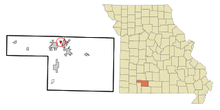
Fremont Hills is a city in Christian County, Missouri, United States. The population was 1,049 at the 2020 census. It is part of the Springfield, Missouri Metropolitan Statistical Area.

East Randolph is a hamlet, census-designated place, and former village in Cattaraugus County, New York, United States. The population was 620 at the 2010 census. East Randolph is adjacent to the northeast part of the former village of Randolph and is mostly within the town of Randolph, with a small part inside the town of Conewango. Their area code is 716.

Deferiet is a village in Jefferson County, New York, United States. The population was 294 at the 2010 census. The village is named after settler Jenika de Ferriet.

Herrings is a hamlet and former village in Jefferson County, New York, United States. The population was 90 at the 2010 census, down from 129 in 2000. The hamlet is named after two brothers who owned a paper mill in the area.

<span class="mw-page-title-main">Prospect, New York</span> Hamlet in New York, United States

Prospect is a hamlet in the town of Trenton, in Oneida County, New York, United States. The population was 291 at the 2010 census. The hamlet is located at the junction of NY 365 and Reference Route 920V west of West Canada Creek. It was an incorporated village from 1890 to 2015.

Richville is a village in St. Lawrence County, New York, United States. The population was 323 at the 2010 census. The name is taken from an early settler.

<span class="mw-page-title-main">Springbrook, North Dakota</span> City in North Dakota, United States

Springbrook is a city in Williams County, North Dakota, United States. The population was 37 at the 2020 census. It is also spelled Spring Brook.

<span class="mw-page-title-main">Aberdeen, Ohio</span> Village in Ohio, United States

Aberdeen is a village in Huntington Township, Brown County, Ohio, United States, along the Ohio River 50 miles (80 km) southeast of Cincinnati. The population was 1,638 at the 2010 census.

<span class="mw-page-title-main">Koppel, Pennsylvania</span> Borough in Pennsylvania, United States

Koppel is a borough in northern Beaver County, Pennsylvania, United States. The population was 708 at the 2020 census. It is part of the Pittsburgh metropolitan area.

<span class="mw-page-title-main">Finleyville, Pennsylvania</span> Borough in Pennsylvania, United States

Finleyville is a borough in Washington County, Pennsylvania, United States, named for John Finley. The population was 375 at the 2020 census. It was built at the junction of Brownsville Road and the 'Washington Road' from Cox's Fort to Catfish Camp, now Washington, Pennsylvania. It was originally known as "Rowgalley" until after a large contingent of Scots-Irish came to town including a number of "Finleys." Reporter Ben Finley's family originates from Finleyville. It is in the Peters Creek watershed.

<span class="mw-page-title-main">Brownville (village), New York</span> Village in New York, United States

Brownville is a village in Jefferson County, New York, United States. The population was 1,119 at the 2010 census, up from 1,022 in 2000. The village is named after Jacob Brown, an early settler and developer.

<span class="mw-page-title-main">Bridgewater (CDP), New York</span> Hamlet and CDP in New York, United States

Bridgewater is a hamlet in Oneida County, New York, United States. The population was 470 at the 2010 census.

<span class="mw-page-title-main">Monroe (village), New York</span> Village in New York, United States

Monroe is a village in Orange County, New York, United States. The population was 9,343 at the 2020 census. It is part of the Poughkeepsie–Newburgh–Middletown, NY Metropolitan Statistical Area as well as the larger New York–Newark–Bridgeport, NY-NJ-CT-PA Combined Statistical Area. The community is named not after President James Monroe; rather its name is taken from that of an early 19th-century New York state senator.

<span class="mw-page-title-main">Edwards, New York</span> Town in New York, United States

Edwards is a town in St. Lawrence County, New York, United States. The population was 1,156 at the 2010 census. The village is named after Edward McCormack, brother of the founder.

<span class="mw-page-title-main">Hermon, New York</span> Town in New York, United States

Hermon is a town in St. Lawrence County, New York, United States. The population was 1,108 at the 2010 census. Hermon is named after Mount Hermon in Israel, which is the name corresponding to Mount Jabal al-Sheikh in Syria. The town contains a hamlet also called Hermon, and is in the south-central part of the county, southwest of Canton.

References

  1. "ArcGIS REST Services Directory". United States Census Bureau. Retrieved September 20, 2022.
  2. Ellen, Martha. "Edwards residents vote to dissolve their village". Watertown Daily Times. Retrieved 9 January 2014.
  3. "US Gazetteer files: 2010, 2000, and 1990". United States Census Bureau. 2011-02-12. Retrieved 2011-04-23.
  4. "Census of Population and Housing". Census.gov. Retrieved June 4, 2016.
  5. "U.S. Census website". United States Census Bureau . Retrieved 2008-01-31.