Star Lake, New York

Last updated

Star Lake, New York
CDP
New York Adirondack.svg
Red pog.svg
Star Lake, New York
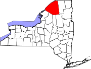
Location within the state of New York
Coordinates: 44°9′36″N75°1′58″W / 44.16000°N 75.03278°W / 44.16000; -75.03278
CountryUnited States
State New York
County St. Lawrence
Area
[1]
  Total4.76 sq mi (12.34 km2)
  Land4.34 sq mi (11.24 km2)
  Water0.42 sq mi (1.10 km2)
Elevation
1,486 ft (453 m)
Population
 (2020)
  Total631
  Density145.46/sq mi (56.16/km2)
Time zone UTC-5 (Eastern (EST))
  Summer (DST) UTC-4 (EDT)
FIPS code 36-70849
GNIS feature ID0977057

Star Lake is a hamlet (and census-designated place) in the Adirondack Mountains of St. Lawrence County, New York, United States. The population was 809 at the 2010 census.

Contents

Star Lake is in the Town of Clifton, but part of the community is in the Town of Fine.

The community is located east of a very angular-shaped lake, also called Star Lake.

History

Star Lake was listed on the National Register of Historic Places in 2012.

Geography

Star Lake is located at 44°09′36″N75°01′58″W / 44.160012°N 75.032800°W / 44.160012; -75.032800 . [2]

According to the United States Census Bureau, the CDP has a total area of 4.8 square miles (12 km2), of which 4.4 square miles (11 km2) is land and 0.4 square miles (1.0 km2) (8.11%) is water.

Star Lake is served by east–west New York State Route 3.

The community is within the Adirondack Park.

Demographics

Historical population
CensusPop.Note
2020 631
U.S. Decennial Census [3]

As of the census [4] of 2000, there were 860 people, 363 households, and 235 families residing in the village. The population density was 194.5 inhabitants per square mile (75.1/km2). There were 526 housing units at an average density of 119.0 per square mile (45.9/km2). The racial makeup of the CDP was 95.58% White, 0.35% African American, 1.63% Native American, 0.47% Asian, 0.23% from other races, and 1.74% from two or more races. Hispanic or Latino of any race were 1.05% of the population.

There were 363 households, out of which 26.7% had children under the age of 18 living with them, 49.3% were married couples living together, 10.5% had a female householder with no husband present, and 35.0% were non-families. 30.3% of all households were made up of individuals, and 15.7% had someone living alone who was 65 years of age or older. The average household size was 2.36 and the average family size was 2.85.

In the community, the population was spread out, with 23.6% under the age of 18, 6.7% from 18 to 24, 26.3% from 25 to 44, 26.6% from 45 to 64, and 16.7% who were 65 years of age or older. The median age was 41 years. For every 100 females, there were 95.9 males. For every 100 females age 18 and over, there were 92.7 males.

The median income for a household in the region was $34,083, and the median income for a family was $42,292. Males had a median income of $40,789 versus $21,806 for females. The per capita income for the CDP was $18,310. About 17.6% of families and 21.0% of the population were below the poverty line, including 30.0% of those under age 18 and 11.3% of those age 65 or over.

Related Research Articles

<span class="mw-page-title-main">Primrose, Alaska</span> Census-designated place in Alaska, United States

Primrose is a census-designated place (CDP) in Kenai Peninsula Borough, Alaska, United States. The population was 78 at the 2010 census, down from 93 at the 2000 census. Primrose is one of a number of small communities located north of Seward along the Seward Highway.

<span class="mw-page-title-main">Sun Lakes, Arizona</span> CDP in Maricopa County, Arizona

Sun Lakes is an unincorporated community and census-designated place (CDP) in Maricopa County, Arizona, United States. The population was 14,868 at the 2020 census. Sun Lakes is an active adult community comprising five country club communities in three homeowner associations. These include the gated communities of Oakwood and IronWood (IronOaks), the gated and non-gated communities of Palo Verde and Cottonwood, and the non-gated community of Sun Lakes 1. Sun Lakes is a master-planned community developed by Robson Communities.

<span class="mw-page-title-main">Blackhawk-Camino Tassajara, California</span> Former census-designated place in California, United States

Blackhawk-Camino Tassajara is a former census-designated place (CDP) in Contra Costa County, California, near the town of Danville. The unincorporated area consisted of the Blackhawk planned community and the surrounding Camino Tassajara area. At the 2000 census, the CDP's population was 10,048. The CDP was split between Blackhawk and Camino Tassajara before the 2010 census.

<span class="mw-page-title-main">Riverview, Delaware</span> CDP in Delaware, United States

Riverview is a census-designated place (CDP) in Kent County, Delaware, United States. It is part of the Dover, Delaware Metropolitan Statistical Area. The population was 2,456 at the 2010 census.

<span class="mw-page-title-main">Lake Asbury, Florida</span> Census-designated place in Florida, United States

Lake Asbury is an unincorporated community and census-designated place (CDP) in Clay County, Florida, United States. The population was 8,700 at the 2010 census, which calls it Asbury Lake.

<span class="mw-page-title-main">Lake Sarasota, Florida</span> Census-designated place in Florida, United States

Lake Sarasota is a census-designated place (CDP) in Sarasota County, Florida, United States. The population was 4,679 at the 2010 census. It is part of the North Port–Sarasota–Bradenton Metropolitan Statistical Area.

Fox Lake Hills is an unincorporated community and census-designated place (CDP) in Lake Villa Township, Lake County, Illinois, United States. Per the 2020 census, the population was 2,684.

<span class="mw-page-title-main">Koontz Lake, Indiana</span> Census-designated place in Indiana, United States

Koontz Lake is an unincorporated community and census-designated place (CDP) in Starke and Marshall counties, in the U.S. state of Indiana. The population was 1,667 at the 2020 census.

Eden Isle is a census-designated place (CDP) in St. Tammany Parish, Louisiana, United States, on the northeast shore of Lake Pontchartrain. The population was 7,041 at the 2010 census. It is part of the New Orleans–Metairie–Kenner Metropolitan Statistical Area. The area is a residential community with homes built on a system of canals connecting to eastern Lake Pontchartrain, which also includes businesses along the Interstate-10 corridor as well as restaurants and marina services within the residential section.

<span class="mw-page-title-main">Victory Lakes, New Jersey</span> Populated place in Gloucester County, New Jersey, US

Victory Lakes is an unincorporated community and census-designated place (CDP) located within Monroe Township, in Gloucester County, in the U.S. state of New Jersey. As of the 2010 United States Census, the CDP's population was 2,111.

<span class="mw-page-title-main">Redford, New York</span> Census-designated place in New York, United States

Redford is a hamlet and census-designated place in the town of Saranac in Clinton County, New York, United States. The population was 477 at the 2010 census.

<span class="mw-page-title-main">Natural Bridge, New York</span> Census-designated place in New York, United States

Natural Bridge is a hamlet and census-designated place (CDP) in Jefferson County, New York, United States. As of the 2010 census it had a population of 365.

Redwood is a hamlet and census-designated place (CDP) in Jefferson County, New York, United States. As of the 2010 census, the population was 605.

Brasher Falls–Winthrop was a census-designated place (CDP) in St. Lawrence County, New York, United States. As of the 2000 census, its population was 1,140. For the 2010 census, the area was counted as two separate CDPs: Brasher Falls in the Town of Brasher and Winthrop in the Town of Stockholm.

<span class="mw-page-title-main">Lake Darby, Ohio</span> Census-designated place in Ohio, United States

Lake Darby is an unincorporated community and census-designated place in Franklin County, Ohio, United States, located mostly in Prairie Township and partly in Brown Township. It is more commonly known among locals as Darby Estates, which is also the name of the older housing development there, with the newer development called "West Point". As of the 2020 census, the CDP had a population of 4,731.

<span class="mw-page-title-main">Lake Wynonah, Pennsylvania</span> CDP in Pennsylvania, United States

Lake Wynonah is a census-designated place (CDP) in Schuylkill County, Pennsylvania, United States. The population was 1,961 at the 2000 census, and 2,640 at the 2010 census. Lake Wynonah is a gated community with two lakes, Fawn Lake and Lake Wynonah, and as of July 2008, there are over 1200 homes and 1500 members. It is in South Manheim and Wayne Townships.

<span class="mw-page-title-main">Lake Morton-Berrydale, Washington</span> Census-designated place in Washington, United States

Lake Morton-Berrydale is a census-designated place (CDP) in King County, Washington, United States. The population was 10,474 at the 2020 census.

<span class="mw-page-title-main">Maple Heights-Lake Desire, Washington</span> Census-designated place in Washington, United States

Maple Heights-Lake Desire is a census-designated place (CDP) in King County, Washington, United States. At the 2010 census, the population was 3,152.

Enfield is a census-designated place (CDP) and the main village in the town of Enfield in Grafton County, New Hampshire, United States. The population of the CDP was 1,571 at the 2020 census, out of 4,465 in the entire town.

Warrensburg is a census-designated place (CDP) in Warren County, New York, United States. The population was 3,208 at the 2000 census. It is part of the Glens Falls Metropolitan Statistical Area.

References

  1. "ArcGIS REST Services Directory". United States Census Bureau. Retrieved September 20, 2022.
  2. "US Gazetteer files: 2010, 2000, and 1990". United States Census Bureau. February 12, 2011. Retrieved April 23, 2011.
  3. "Census of Population and Housing". Census.gov. Retrieved June 4, 2016.
  4. "U.S. Census website". United States Census Bureau . Retrieved January 31, 2008.