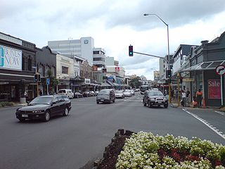
Newmarket is an Auckland suburb to the south-east of the central business district. With its high building density, especially of retail shops, it is considered New Zealand's premier retailing area, and a rival of local competitor Auckland CBD.

Queen Street is the major commercial thoroughfare in the Auckland CBD, Auckland, New Zealand's main population centre. The northern end is at Queens Wharf on the Auckland waterfront, adjacent to the Britomart Transport Centre and the Downtown Ferry Terminal. The road is close to straight, the southern end being almost three kilometres away in a south-southwesterly direction on the Karangahape Road ridge, close to the residential suburbs in the interior of the Auckland isthmus.

Epsom is a suburb of Auckland, New Zealand. It is located in the centre of the Auckland isthmus between Mount Eden and Greenlane, south of Newmarket, and 5 km (3.1 mi) south of the Auckland City Centre.
Westleigh is a suburb in the Upper North Shore region of Sydney in the state of New South Wales, Australia, 22 kilometres north-west of the Sydney central business district in the local government area of Hornsby Shire.

Remuera is an affluent suburb in Auckland, New Zealand. It is located four kilometres southeast of the city centre. Remuera is characterised by many large houses, often Edwardian or mid 20th century. A prime example of a "leafy" suburb, Remuera is noted for its quiet tree lined streets. The suburb has numerous green spaces, most obvious of which is Ōhinerau / Mount Hobson – a volcanic cone with views from the top overlooking Waitematā Harbour and Rangitoto.

Freemans Bay is the name of a former bay and now inner city suburb of Auckland, in the North Island of New Zealand. The bay has been filled in to a considerable extent, with the reclamation area now totally concealing the ancient shoreline. Historically a poor and often disreputable quarter, it is now a comparatively wealthy and desirable neighbourhood known for its mix of heritage homes and more recent single-dwelling houses, as well as for its two large parks.
Western Springs is a residential suburb in the city of Auckland in the north of New Zealand. It is located four kilometres to the west of the city centre, Auckland CBD. The park is situated to the north of State Highway 16 and the residential suburb is located southeast of the park on the opposite side of State Highway 16.

Sylvia Park is a large business park and shopping centre in the Auckland suburb of Mount Wellington in New Zealand. Less commonly known, the area around the centre is also called Sylvia Park. The area is located adjacent to two major interchanges of the Auckland Southern Motorway – the South Eastern Highway and Mount Wellington Highway.
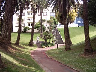
Myers Park is a narrow park in central Auckland, New Zealand, running parallel to the upper part of Queen Street. It is characterised by steep, grassed slopes and canopied with a mixture of large exotic and native trees, including an alley of large palm trees.

Grafton Bridge is a road bridge spanning Grafton Gully in Auckland, New Zealand. Built of reinforced concrete in 1910, it connects the Auckland CBD and Karangahape Road with Grafton. It spans about 97.6 metres, rises 25.6 metres above the abutments to a height of around 43 metres over the gully. When the bridge was constructed, it contained the largest reinforced concrete arch in the world.
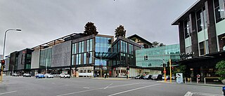
Westfield Newmarket is a shopping centre in Newmarket, a central suburb of Auckland, New Zealand. The centre initially opened in the 1980s; in early 2018, the centre closed for a major re-build and expansion; it re-opened in August 2019 after an 18 month closure. The centre is located at 277 Broadway and, since expansion, 309 Broadway; it was often referred to simply as 277 prior to refurbishment.

The Auckland Central Business District (CBD), or Auckland city centre, is the geographical and economic heart of the Auckland metropolitan area. It is the area in which Auckland was established in 1840, by William Hobson on land gifted by mana whenuahapū Ngāti Whātua Ōrākei. It is New Zealand's leading financial hub, and the centre of the country's economy; the GDP of the Auckland Region was NZD$139 billion in the year ending September 2023.

The Victoria Park Viaduct is a major motorway viaduct carrying the Auckland Northern Motorway over the Victoria Park area in the Auckland city centre, New Zealand. Construction began in 1959, and the bridge was opened on 5 April 1962. Due to the high traffic volumes passing through on their way to and from North Shore City, and because the viaduct is only four lanes wide in total, the bridge over the park is considered "one of the country's worst traffic bottlenecks", with around 200,000 vehicles a day.
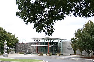
Auckland Botanic Gardens is a botanical garden in the New Zealand city of Auckland. It is located in the suburb of Manurewa, in the Manurewa Local Board Area. The garden covers 64 hectares, and holds more than 10,000 plants.

Auckland Council is the local government council for the Auckland Region in New Zealand. It is a territorial authority that has the responsibilities, duties and powers of a regional council and so is a unitary authority, according to the Local Government Act 2009, which established the council. The governing body consists of a mayor and 20 councillors, elected from 13 wards. There are also 149 members of 21 local boards who make decisions on matters local to their communities. It is the largest council in Oceania, with a $3 billion annual budget, $29 billion of ratepayer equity, and 9,870 full-time staff as of 30 June 2016. The council began operating on 1 November 2010, combining the functions of the previous regional council and the region's seven city and district councils into one "super council" or "super city".

Blandford Park, in Auckland, New Zealand, was the home of association football in Auckland for much of the 20th century, and one of the country's main football grounds. Located in Grafton Gully, northeast of Grafton Bridge, roughly between the northern part of Whitaker Place and the Auckland Bowls Club in Grafton Mews, it was razed in the mid-1960s, and its site is now occupied by on- and off-ramps to the Auckland Central Motorway Junction.

The Parnell Tunnel is a railway tunnel under Parnell, Auckland, New Zealand. It is 344.5 metres (1,130 ft) long, and is on the Newmarket Line.

Symonds Street Cemetery is a historic cemetery and park in central Auckland, New Zealand. It is in 5.8 hectares of deciduous forest on the western slope of Grafton Gully, by the corner of Symonds Street and Karangahape Road, and is crossed by the Grafton Bridge. The street is named for William Cornwallis Symonds, a British Army officer prominent in the early colonisation of New Zealand. It has a Historic Place – Category I listing with the New Zealand Historic Places Trust. Maintenance and administration of the cemetery is provided by the Auckland Council.

Coxs Bay or Opoututeka is a bay located in the Waitematā Harbour, within the Auckland region of New Zealand. It is situated between the settlements of Westmere to the southwest and Herne Bay to the northeast, with Grey Lynn to the southeast. The bay is protected from the west by Te Tokoroa/Meola Reef, the end of one of the longest lava flows in the Auckland volcanic field.
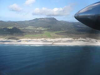
Claris is a settlement on the east coast of Great Barrier Island in the Auckland Region of New Zealand. Though less populous than the main seaport area of Tryphena on the west coast, Claris functions as the administrative centre for the island, and a large proportion of its commercial and community services are based there.


