Nickel Plate Mine

Last updated
Nickel Plate Mine
Location
Canada British Columbia location map 2.svg
Schlaegel und Eisen nach DIN 21800.svg
Nickel Plate Mine
Location in British Columbia
Location Hedley
Province British Columbia
Country Canada
Coordinates 49°22′15″N120°02′51″W / 49.370937°N 120.047562°W / 49.370937; -120.047562 Coordinates: 49°22′15″N120°02′51″W / 49.370937°N 120.047562°W / 49.370937; -120.047562
Production
Products
History
Discovered1897
Opened1900
Closed1955

Nickel Plate Mine was a gold mine on Nickel Plate Mountain at Hedley in the Similkameen region of southern British Columbia.

Contents

Discoveries

In 1894, Keremeos rancher, J.L. Coulthard, in partnership with Edgar Dewdney, staked three claims on what became known as Nickel Plate Mountain, but allowed the claims to lapse. In 1897, C. Johnston and Albert Jacobsen staked the Copper Cleft and the Mound claims for their sponsor, W.Y. Williams, manager of the Granby mines at Phoenix, and Peter Scott staked the Rollo for Robert R. Hedley, manager of the Hall Mines smelter at Nelson. Meanwhile, Constantine H. Arundel and Frances E.R. Woolaston, on finding surface traces of gold ore, staked the Bulldog, the Sunnyside, the Copperfield, the Iron Duke, the Horsefly, the Exchange Fraction, and the Nickel Plate. The subsequent gold rush led to registered claims covering almost the whole mountain by the end of 1898. The mountain base tent settlement on Twenty Mile (Hedley) Creek was called Hedley camp, after Robert R. Hedley. [1] [2]

Construction

In 1899, Marcus Daly bought the Arundel and Woolaston claims for $60,000. Daly arranged for an initial 35-horse packtrain to carry supplies 40 kilometres (25 mi) across the mountain range from Fairview. Daly bought almost all the claims on the mountain, which he consolidated as Nickel Plate mine, incorporated as the Yale Mining Company (YMC). He established a small settlement on top of the mountain, but needed a more efficient means to bring in supplies, and transport out ore. By yearend 1900, aided by a $4,000 provincial grant, he had constructed a wagon road to Penticton, from where the Canadian Pacific Railway lake ferries linked to the CP rail network. After his death that November, his estate assumed control.

In 1903, the estate obtained a provincial charter for the Daly Reduction Company (DRC) to build and operate a concentrator and conveyance infrastructure, the DRC becoming the YMC's only asset. At the southeastern edge of Hedley Camp, the components of the DRC 200-ton daily capacity concentrator were powered by a 5-kilometre (3 mi) water flume, sourced from an upstream dam on the creek. Also built that year, the tramway delivered ore to the tipple, which gravity fed the concentrator. [1] The two-stage tramway, which moved loaded ore gondolas from the mine, 0.5 kilometres (0.3 mi) vertically above, comprised a 3.0-kilometre (10,000 ft) narrow gauge track, reputed to have been the longest example in the world. [3] Pelton impact water wheels powered the rock pulverizers, and air compressors that supplied a hoist and rock drills within the mine. A Cassel water wheel powered an alternating current generator that supplied the mine's electric locomotives. [1]

Production

After testing, production began in 1904. An air-operated hoist hauled two-ton cars from the mine to the surface, where they were emptied into 12-ton gondolas. Electric locomotives hauled the gondolas 2.4 kilometres (1.5 mi) to a 200-ton storage hopper, which supplied the tramway gondolas. The tramway was two-staged, because 2.5-centimetre (1 in)-diameter steel cable was unavailable in lengths greater than one mile. Following the contours of the terrain, the junction was dog legged, where cars were manually transferred between the two cable sets. At the centre of each section of single track was a short double-track passing configuration. Any supplies would be carried by the empty ascending gondolas. The dried final product was shipped in sacks to the Tacoma smelter. The Chuchuwayha Indian Reserve No. 2 was reduced to accommodate a tailings pond. [1]

To access a separate part of its property, DRC approached Duncan Woods, owner of the small Mascot claim that year. However, Woods rejected the offer to tunnel through and mine his claim. When DRC had the properties resurveyed, the Mascot claim shrank to only 7 hectares (17 acres). [4]

By summer 1907, the Daly mill was processing about 115 tons of ore daily. Armed guards escorted the gold output to Penticton for shipping by a circuitous route to the Everett smelter. When the Vancouver, Victoria and Eastern Railway (VV&E) rail head reached Keremeos that July, the journey was halved by exclusively using the Great Northern Railway (GN) network. [1]

New owners

In 1909, believing the best ore depleted, the Daly estate sold the operation for $760,000 to U.S. Steel subsidiary, the Exploration Syndicate of New York. Reorganized as the Hedley Gold Mining Co. (HGM), geological surveys located additional deposits. HGM electrified the mill, by redirecting most of the waterflow. [1] The 1909 opening of the VV&E line through Hedley to Princeton [5] provided a source for cheap coal. In 1911, the laying of track through the VV&E tunnel at Princeton created a short direct link to the Coalmont deposits. [6]

HGM installed three new coal-fired boilers to power an electric generator for use during periods of inadequate waterflow. By 1912, production was over 200 tons daily. In 1917, the leaching process was abandoned. To address the unreliable water supply from the creek, a run-of-river hydroelectricity dam was opened on the Similkameen River in 1915. However, the river proved as problematic as the creek during winter freezing or chunks of ice battering and damaging the dam, leading to closures during 1920 and 1925. [1] In 1920, HGM gained government permission to cut a 61-metre (200 ft) tunnel through the Mascot claim, without paying compensation. [4] After years of marginal profitability, operations ceased in 1931. [1]

In 1933, the South American Development Company subsidiary, Kelowna Exploration (KelEx), purchased the property. A $250,000 rehabilitation was undertaken before the 1935 reopening. A new hook up drew on the West Kootenay Power grid, and fed back surplus power from the dam, until winter damage destroyed the dam that year. Co-operation with HMG led to connected shafts allowing cross-ventilation and improved drainage. On completion in 1937, the current access road was shared with HMG, replacing the latter's previous deteriorated route. HMG abandoned operations in 1949, and KelEx in 1955. [7]

Revival

In 1971, the descendants of the two companies merged to become the Mascot Nickel Plate Mines, consolidating the entire mountain under one owner. In 1978, after no activity, the name became Mascot Gold Mines (MGM). In 1987, MGM demolished the buildings and facilities from the former small Nickel Plate settlement, and built a new processing plant. The next year, open-pit mining commenced. To finance the $10 million project and pursue interests farther afield, MGM amalgamated with several smaller mining companies to form the Corona Corporation, with subsequent restructuring. Nickel Plate production reached 4,000 tons daily, but by 1996, the mine was exhausted and operations ceased.

In 1987, Candorado Mines began reworking the former tailings for missed gold. This intermittent activity, which continued for nearly a decade, generated insufficient profit. [8]

Remnants

Just before the western outskirts of Hedley, a pullout with a green historic marker provides an eastward viewpoint of the straight scar of the former tramway route down the face of Nickel Plate Mountain. Not clearly visible are looping rolls of rusting cable high up on the mountain. [3]

Map

Related Research Articles

<span class="mw-page-title-main">Rossland, British Columbia</span> City in British Columbia, Canada

Rossland is in the West Kootenay region of south central British Columbia. High in the Monashee Mountains, the city lies immediately east of the intersections of BC highways 3B and 22. The facilities provide a winter base for the nearby multi-peak ski hills of the Red Mountain Resort. In the non-winter months Rossland is frequented by mountain bikers, with golf and fishing options nearby as well.

Princeton is a town in the Similkameen region of southern British Columbia, Canada. It lies just east of the Cascade Mountains, which continue south into Washington, Oregon and California. The Tulameen and Similkameen Rivers converge here. At the 2016 census, the population was 2,828.

Hedley is an unincorporated community near the mouth of Hedley Creek in the Similkameen region of southern British Columbia. The former mining town, on BC Highway 3, is by road about 74 kilometres (46 mi) southwest of Penticton and 38 kilometres (24 mi) southeast of Princeton.

<span class="mw-page-title-main">Salmo, British Columbia</span> Village in British Columbia, Canada

Salmo is in the West Kootenay region of southeastern British Columbia. The village municipality is mostly on the north side of Erie Creek at the confluence with the Salmo River. The place lies largely east of the junction of BC Highway 3, and BC Highway 6.

<span class="mw-page-title-main">Dewdney Trail</span>

The Dewdney Trail is a 720 km (450 mi) trail in British Columbia, Canada that served as a major thoroughfare in mid-19th century British Columbia. The trail was a critical factor in the development and strengthening of the newly established British colony of British Columbia, tying together mining camps and small towns that were springing up during the gold rush era prior to the colony's joining Canada in 1871. Establishing this route became important and urgent for the colony when many new gold finds occurred at locations near the US border that at the time were much more easily accessed from Washington Territory than from the then barely settled parts of the Lower Mainland and Cariboo. Approximately 80 percent of the trail's route has been incorporated into the Crowsnest Highway.

Mascot Mine of Hedley was a gold mine on Nickel Plate Mountain at Hedley in the Similkameen region of southern British Columbia.

The Similkameen Country, also referred to as the Similkameen Valley or Similkameen District, but generally referred to simply as The Similkameen or more archaically, Similkameen, is a region roughly coinciding with the basin of the river of the same name in the Southern Interior of British Columbia. The term "Similkameen District" also refers to the Similkameen Mining District, a defunct government administrative district, which geographically encompasses the same area, and in more casual terms may also refer to the Similkameen electoral district, which was combined with the Grand Forks-Greenwood riding by the time of the 1966 election. The Similkameen Country has deep historical connections to the Boundary Country and the two are sometimes considered one region, partly as a result of the name of the electoral district. It is also sometimes classed as being part of the Okanagan region, which results from shared regional district and other administrative boundaries and names. The term "Similkameen District" may also historically refer to the Similkameen Division Yale Land District, which also includes Osoyoos and the Boundary Country to Osoyoos' east.

Spillimacheen is an unincorporated community near the mouth of the Spillimacheen River on the east shore of the Columbia River, in the East Kootenay region of southeastern British Columbia. The locality, on BC Highway 95, is by road about 183 kilometres (114 mi) north of Cranbrook and 64 kilometres (40 mi) southeast of Golden.

Big Interior Mountain is in central Vancouver Island, British Columbia. This snow-covered mountain in Strathcona Provincial Park is about 42 km (26 mi) northeast of Tofino and 5 km (3 mi) southwest of Mount Rosseau.

The Cobalt silver rush started in 1903 when huge veins of silver were discovered by workers on the Temiskaming and Northern Ontario Railway (T&NO) near the Mile 103 post. By 1905 a full-scale silver rush was underway, and the town of Cobalt, Ontario sprang up to serve as its hub. By 1908 Cobalt produced 9% of the world's silver, and in 1911 produced 31,507,791 ounces of silver. However, the good ore ran out fairly rapidly, and most of the mines were closed by the 1930s. There were several small revivals over the years, notably in World War II and again in the 1950s, but both petered out and today there is no active mining in the area. In total, the Cobalt area mines produced 460 million ounces of silver.

<span class="mw-page-title-main">Rock Creek, British Columbia</span> Unincorporated settlement in British Columbia, Canada

Rock Creek is in the Boundary Country region of south central British Columbia. The unincorporated settlement is mostly on the southwest side of the Kettle River at the confluence with Rock Creek. The place lies at the junction of BC Highway 33, and BC Highway 3.

Granby Consolidated Mining, Smelting and Power Co. was established by charter to operate in the Boundary region of southern British Columbia. Primarily involved in the mining and smelting of copper, the conglomerate became a publicly traded company. The various corporate operating names within the former group mostly specified the Granby identity.

Camborne is a ghost town in the West Kootenay region of southeastern British Columbia. The former mining community was at the mouth of Pool Creek on the east side of the Incomappleux River. The locality is about 78 kilometres (48 mi) by road north of Nakusp and 91 kilometres (57 mi) by road and ferry southeast of Revelstoke.

Kearsarge or Kearsarge City is a former mining settlement in Inyo County, eastern California. It was located high on the east slope of the Sierra Nevada, near Kearsage Pass, 8 miles (13 km) west of present-day town of Independence, California.

Mukondo Mine is a copper and cobalt mine in Katanga Province, Democratic Republic of the Congo. As of 2011 it was operated by the Central African Mining and Exploration Company (CAMEC). It may be the richest cobalt reserve in the world.

Gold Trails and Ghost Towns is a Canadian historical documentary show, created and produced by television station CHBC-TV in Kelowna, British Columbia for Canadian syndication and hosted by Mike Roberts with historian/storyteller Bill Barlee. The show was filmed in a studio which resembled an old trapper's cabin. Mike and Bill discussed prospectors and the history of British Columbia around 1900.

<span class="mw-page-title-main">Carajás mine</span> Iron mine in Brazil

The Carajás Mine is the largest iron ore mine in the world. It is located in the municipality of Parauapebas, state of Pará in the Carajás Mountains of Northern Brazil. The mine is operated as an open-pit mine, and is estimated to contain roughly 7.2 billion metric tonnes of iron ore, plus gold, manganese, bauxite, copper, and nickel. The mine is run by Vale and was previously part-owned with US Steel until 1977.

<span class="mw-page-title-main">Britannia Mines Concentrator</span>

The Britannia Mines Concentrator is a National Historic Site of Canada. The large, inclined gravity mill was built on the northwest side of Mount Sheer to assist the transfer of copper ore through the chemical and mechanical processes of the plant. It is a landmark in Britannia Beach, British Columbia some forty-five kilometers north of Vancouver.

<span class="mw-page-title-main">Vancouver, Victoria and Eastern Railway</span> Defunct Canadian railway line

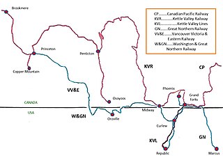
The Vancouver, Victoria and Eastern Railway (VV&E) was a railway line proposed to connect Metro Vancouver with the Kootenays, in Canada. After acquisition by the Great Northern Railway (GN), most of the route was built, but a through service, using the arranged running rights on the tracks of other companies, never eventuated.

References

  1. 1 2 3 4 5 6 7 8 "The Nickel Plate Mine". www.crowsnest-highway.ca.
  2. "Hedley Creek (creek)". BC Geographical Names .
  3. 1 2 "Into Hedley". www.crowsnest-highway.ca.
  4. 1 2 "Duncan Woods and the Mascot Fraction". www.crowsnest-highway.ca.
  5. "Daily Colonist, 28 Dec 1909". www.archive.org. p. 15.
  6. "Similkameen Star, 26 Jul 1911". www.library.ubc.ca. p. 1.
  7. "Mining the Mountain". www.crowsnest-highway.ca.
  8. "Return to Nickel Plate". www.crowsnest-highway.ca.