Norfield, Mississippi

Last updated

Norfield, Mississippi
Norfield, Mississippi railroad depot.jpg
Illinois Central Railroad depot in Norfield
USA Mississippi location map.svg
Red pog.svg
Norfield
Usa edcp location map.svg
Red pog.svg
Norfield
Coordinates: 31°24′28″N90°28′02″W / 31.40778°N 90.46722°W / 31.40778; -90.46722
Country United States
State Mississippi
County Lincoln
Elevation
407 ft (124 m)
Time zone UTC-6 (Central (CST))
  Summer (DST) UTC-5 (CDT)
Area code(s) 601 & 769
GNIS feature ID674932 [1]

Norfield is an unincorporated community in Lincoln County, Mississippi, United States. [1] [2]

Contents

History

The community was founded in 1886 as a sawmill town. [3] Norfield's name is a portmanteau of the surnames of Frederick Norwood and John S. Butterfield, who founded the Norwood-Butterfield Lumber Company. [4] The sawmill in Norfield was the first sawmill in the southern United States to use a bandsaw to cut yellow pine. [5] In 1900, the community had a population of 347 and was estimated to have a population of 700 six years later. [6] By 1930, the community had the second-largest population in Lincoln County and had a theater, hotel, and golf course. [4]

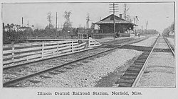
Norfield is located on the Canadian National Railway. [7] The Norwood-Butterfield Company operated the Natchez, Columbia & Mobile Railroad, a standard gauge logging railroad that ran 30 miles east from Norfield. The railroad operated six locomotives. [8]

A post office operated under the name Norfield from 1891 to 1953. [9]

Notable people

Notes

  1. 1 2 "Norfield, Mississippi". Geographic Names Information System . United States Geological Survey, United States Department of the Interior.
  2. Mississippi Department of Transportation-Lincoln County
  3. Campbell, Brett (April 26, 2021). "Norfield historical marker approved". The Daily Leader. Retrieved February 25, 2023.
  4. 1 2 "Norfield". hmdb.org. Retrieved February 25, 2023.
  5. "Perfection in the Manufacture of Mississippi Longleaf Pine". American Lumberman (1665): 44. April 20, 1907.
  6. Rowland, Dunbar (1907). Mississippi: Comprising Sketches of Counties, Towns, Events, Institutions, and Persons, Arranged in Cyclopedic Form (PDF). Vol. 2. Southern Historical Publishing Association. p. 345.
  7. Howe, Tony. "Norfield, Mississippi". Mississippi Rails. Retrieved February 25, 2023.
  8. Howe, Tony. "Norwood & Butterfield Co. (1891-1900)". Mississippi Rails. Retrieved February 25, 2023.
  9. "Lincoln County". Jim Forte Postal History. Retrieved February 25, 2023.
  10. Komara, Edward; Johnson, Greg (2014). 100 Books Every Blues Fan Should Own. Lanham, Maryland: Rowman & Littlefield. p. 92. ISBN   978-0-8108-8921-7.


Related Research Articles

Nesbit is an unincorporated community in DeSoto County, Mississippi, United States.

Hudsonville,, is an unincorporated community in Marshall County, Mississippi, United States. It is located in the hill country of north Mississippi.

Penns, also known as Penn or Penns Station, is an unincorporated community in Lowndes County, Mississippi. Penns is located south of Artesia on U.S. Route 45.

<span class="mw-page-title-main">Pine Belt (Mississippi)</span> Region in southeast Mississippi

The Pine Belt, also known as the Piney Woods, is a region in Southeast Mississippi. The region gets its name from the longleaf pine trees that are abundant in the region. The Pine Belt includes 9 counties: Covington, Forrest, Greene, Jefferson Davis, Jones, Lamar, Marion, Perry, and Wayne.

Foxworth,, is an unincorporated community and Census-designated place in Marion County, Mississippi. It is located near the intersection of U.S. Route 98 and Mississippi Highway 35, approximately three miles southwest of Columbia along the west bank of the Pearl River.

Goss,, is an unincorporated community in Marion County located 8 miles northwest of Columbia.

<span class="mw-page-title-main">Bond, Mississippi</span> Census-designated place in Mississippi, United States

Bond is a census-designated place and unincorporated community in northern Stone County, Mississippi, United States. The community is situated approximately 3 miles (4.8 km) north of Wiggins on U.S. Route 49, and is part of the Gulfport-Biloxi metropolitan area. It was first named as a CDP in the 2020 Census which listed a population of 506.

Bobo is a census-designated place and unincorporated community in Coahoma County, Mississippi, United States. Bobo is located on U.S. routes 61 and 278, southwest of Clarksdale.

<span class="mw-page-title-main">Berclair, Mississippi</span> Unincorporated community in Mississippi, United States

Berclair is an unincorporated community located in Leflore County, Mississippi, United States. Berclair is approximately 3 miles (4.8 km) west of Itta Bena. It is part of the Greenwood, Mississippi micropolitan area.

Leaf is a census-designated place and unincorporated community in Greene County, Mississippi, United States.

Ruth is an unincorporated community in Lincoln County, Mississippi, United States. Its ZIP code is 39662.

Eddiceton is an unincorporated community in Franklin County, Mississippi, United States. The community is located along U.S. Route 84 4.4 miles (7.1 km) northeast of Bude.

Logtown, Mississippi is a ghost town located in Hancock County, Mississippi. It is one of several ghost towns situated within the 125,000 acre acoustic buffer zone of NASA's John C. Stennis Space Center. It stood along the banks of the Pearl River and had been the site of a very large sawmill and logging community.

<span class="mw-page-title-main">Wautubbee, Mississippi</span> Unincorporated community in Mississippi, United States

Wautubbee is an unincorporated community in Clarke County, Mississippi, United States.

Ora is an unincorporated community in Covington County, Mississippi, United States. It was incorporated in 1901 and had a post office from 1890 until 1922. Ora's population grew from 28 in 1900 to several hundred by 1920, and it was once home to six general stores, two lumber companies, and a sawmill. It was a station on the Gulf and Ship Island Railroad. Closure of the station was requested in 1921.

Mahned, also known as Mixons Mill, is an unincorporated community located in Perry County, Mississippi.

Avera is an unincorporated community in Greene County, Mississippi. Avera was originally located along the Chickasawhay River. The community was named for Powell Avera, who settled the area prior to 1860. Around 1880, the community was moved to its present location. The former location is now known as Old Avera.

Meehan is an unincorporated community in Lauderdale County, Mississippi, United States. Its ZIP code is 39307. The community is also known as Meehan Junction, as it was located at the crossing of the former Alabama & Vicksburg Railroad and the Tallahatta Railway.

Piave is an unincorporated community in Greene County, Mississippi.

<span class="mw-page-title-main">Barnett, Mississippi</span> Unincorporated community in Mississippi, United States

Barnett,, is an unincorporated community in Clarke County, Mississippi, United States.