North Carolina Highway 186

Last updated

NC 186.svg

North Carolina Highway 186
NC 186 map.svg
Route information
Maintained by NCDOT
Length23.4 mi [1] (37.7 km)
Existed1975–present
Major junctions
West endNC 48.svg NC 48 near Gaston
 
East endVirginia 186.svg SR 186 at the Virginia state line
Location
Counties Northampton
Highway system
NC 184.svg NC 184 NC 191 NC 191.svg

North Carolina Highway 186 (NC 186) is a primary state highway in the U.S. state of North Carolina. Entirely in Northampton County, it helps facilitate truck traffic parallel to I-95 and connect the communities of Seaboard and Margarettsville.

A state highway, state road, or state route is usually a road that is either numbered or maintained by a sub-national state or province. A road numbered by a state or province falls below numbered national highways in the hierarchy. Roads maintained by a state or province include both nationally numbered highways and un-numbered state highways. Depending on the state, "state highway" may be used for one meaning and "state road" or "state route" for the other.

North Carolina State of the United States of America

North Carolina is a state in the southeastern region of the United States. It borders South Carolina and Georgia to the south, Tennessee to the west, Virginia to the north, and the Atlantic Ocean to the east. North Carolina is the 28th-most extensive and the 9th-most populous of the U.S. states. The state is divided into 100 counties. The capital is Raleigh, which along with Durham and Chapel Hill is home to the largest research park in the United States. The most populous municipality is Charlotte, which is the second-largest banking center in the United States after New York City.

Northampton County, North Carolina County in the United States

Northampton County is a county located in the U.S. state of North Carolina. As of the 2010 census, the population was 22,099. Its county seat is Jackson.

Contents

Route description

NC 186 is a two-lane rural highway that traverses 23.4 miles (37.7 km) from NC 48 near Gaston, to the Virginia state line near Margarettsville. The first 3.4 miles (5.5 km) parallel I-95 heading south before joining NC 46 towards Garysburg. Once in Garysburg, its concurrency with NC 46 ends and then briefly overlaps with US 301 before it heads in a northeasterly direction out of town. It then proceeds to connect Gumberry, Seaboard and Margarettsville, before crossing the state line into Virginia, becoming Virginia State Route 186 (SR 186), and heading towards Branchville, Virginia and Boykins, Virginia.

North Carolina Highway 48 highway in North Carolina

North Carolina Highway 48 (NC 48) is a primary state highway in the U.S. state of North Carolina that principally connects the cities of Rocky Mount and Roanoke Rapids. The route offers an alternative to US 301 and I-95.

Gaston, North Carolina Town in North Carolina, United States

Gaston is a town in Northampton County, North Carolina, United States. The population was 1,152 at the 2010 census. It is part of the Roanoke Rapids, North Carolina Micropolitan Statistical Area.

Virginia State of the United States of America

Virginia, officially the Commonwealth of Virginia, is a state in the Southeastern and Mid-Atlantic regions of the United States located between the Atlantic Coast and the Appalachian Mountains. Virginia is nicknamed the "Old Dominion" due to its status as the first English colonial possession established in mainland North America and "Mother of Presidents" because eight U.S. presidents were born there, more than any other state. The geography and climate of the Commonwealth are shaped by the Blue Ridge Mountains and the Chesapeake Bay, which provide habitat for much of its flora and fauna. The capital of the Commonwealth is Richmond; Virginia Beach is the most populous city, and Fairfax County is the most populous political subdivision. The Commonwealth's estimated population as of 2018 is over 8.5 million.

History

Established around 1975 as a renumbering of NC 195; the number change was to match with Virginia's SR 186, which was originally SR 195 before I-195 was established in Richmond, Virginia, around 1970.[ citation needed ] It remained unchanged until May 21, 2013, when it was extended west and north from its former terminus at US 301 to NC 48. The justification for the extension was to help facilitate truck traffic and serve the Northampton Commerce Park and Enviva Industrial Facility, on what was SR 1200 (Lebanon Church Road and James Jones Road); it can also be used as an alternate route for I-95 in the event traffic has to be rerouted. [2]

Interstate 195 (Virginia) highway in Virginia

Interstate 195 (I-195) is an Interstate Highway in the U.S. state of Virginia. Known as the Beltline Expressway, the highway runs 3.50 miles (5.63 km) from Virginia State Route 195, a toll road that continues south into Downtown Richmond, north to I-64 and I-95 on the northern edge of Richmond. I-195 passes through the West End of Richmond and connects I-64 and I-95 with U.S. Route 33 and US 250, which follow Broad Street, and with SR 76, a toll road that links Richmond with the Southside of the metropolitan area.

Richmond, Virginia Capital of Virginia

Richmond is the capital of the Commonwealth of Virginia in the United States. It is the center of the Richmond Metropolitan Statistical Area (MSA) and the Greater Richmond Region. Richmond was incorporated in 1742 and has been an independent city since 1871.

North Carolina Highway 195

NC 195.svg

North Carolina Highway 195
Location Garysburg-Virginia state line
Length15.8 mi [3] (25.4 km)
Existed1938–1975

North Carolina Highway 195 (NC 195) was established around 1938 as a renumbering of NC 305 between Garysburg to Seaboard, then continuing east on new primary routing into Virginia becoming SR 195. Around 1970, SR 195 was renumbered to SR 186; North Carolina reciprocated in 1975.[ citation needed ]

North Carolina Highway 305

North Carolina Highway 305 (NC 305) is a primary state highway in the U.S. state of North Carolina. NC 305 runs from US 13 north of Windsor to NC 186 in Seaboard. NC 305 is an original state highway and appeared on the 1936 official map of North Carolina from Seaboard to Aulander. NC 305 has an average of 1663 cars per day on the highway.

Junction list

The entire route is in Northampton County.

Locationmi [1] kmDestinationsNotes
0.00.0NC 48.svg NC 48  Gaston Western terminus
3.45.5NC 46.svg NC 46 west Gaston West end of NC 46 overlap
4.06.4I-95.svg I-95  Roanoke Rapids, Rocky Mount, Emporia Exit 176 (I-95)
Garysburg 7.411.9US 301.svgNC 46.svg US 301 south / NC 46 ends Weldon South end of US 301 overlap and eastern terminus of NC 46
7.612.2US 301.svg US 301 north Pleasant Hill North end of US 301 overlap
Seaboard 14.623.5NC 305.svg NC 305 south (Main Street) Jackson Northern terminus of NC 305
23.437.7Virginia 186.svg SR 186 east Branchville Eastern terminus, Virginia state line
1.000 mi = 1.609 km; 1.000 km = 0.621 mi

Related Research Articles

North Carolina Highway 75 highway in North Carolina

North Carolina Highway 75 (NC 75) is a primary state highway in the U.S. state of North Carolina. Its entire length runs through Union County and serves as the primary connector between the towns of Waxhaw, Mineral Springs, and Monroe. The route roughly parallels a CSX railroad line for its entire span.

North Carolina Highway 103 Highway in North Carolina

North Carolina Highway 103 (NC 103) is a primary state highway in the U.S. state of North Carolina. It runs entirely in Surry County. It connects the city of Mount Airy with the northern end of Surry County and Virginia State Route 103 (SR 103). A 6-mile (9.7 km) segment of the highway is known as the Donna Fargo Highway, named to honor a local country music star.

North Carolina Highway 49 highway in North Carolina

North Carolina Highway 49 (NC 49) is a primary state highway in the U.S. state of North Carolina. It traverses much of the Piedmont region of North Carolina.

North Carolina Highway 20 highway in North Carolina

North Carolina Highway 20 is a 27-mile (43 km) North Carolina state highway that runs through Hoke, Robeson and Bladen counties. It serves as a major road in each of the three incorporated communities through which it passes. The route is co-designated as St. Pauls Road in Raeford, Main Street in Lumber Bridge, and Broad Street in St. Pauls.

North Carolina Highway 97 highway in North Carolina

North Carolina Highway 97 (NC 97) is a primary state highway in the U.S. state of North Carolina, connecting the cities of Zebulon and Rocky Mount with the vast rural coastal plains.

North Carolina Highway 96 highway in North Carolina

North Carolina Highway 96 (NC 96) is a 112-mile-long (180 km) primary state highway in the U.S. state of North Carolina. It is a predominantly rural highway that travels north-south, from NC 55, west of Newton Grove, to the Virginia state line near Virgilina, Virginia, where it continues on as Virginia State Route 96. It also connects the cities of Smithfield, Selma, Zebulon, Youngsville and Oxford.

North Carolina Highway 87 highway in North Carolina

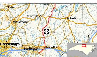
North Carolina Highway 87 (NC 87) is a primary state highway in the U.S. state of North Carolina. NC 87 begins in the Atlantic coastal town of Southport and crosses into Virginia at the Virginia state line five miles (8 km) north of Eden in Rockingham County. At 240 miles (390 km) in length, NC 87 is the second longest state highway in the U.S. state of North Carolina. Labeled as a north–south route, NC 87 travels along a relatively straight southeast–northwest path, connecting Cape Fear region with the Piedmont and connecting the cities of Fayetteville, Sanford, and Burlington.

North Carolina Highway 27 highway in North Carolina

North Carolina Highway 27 (NC 27) is a primary state highway in the U.S. state of North Carolina. The route traverses 198 miles (319 km) through southern and central North Carolina, about 100 miles (160 km) of it as a concurrency with NC 24.

Virginia State Route 186 highway in Virginia

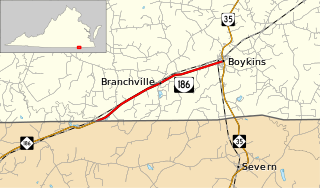
State Route 186 is a primary state highway in the U.S. state of Virginia. The state highway runs 6.21 miles (9.99 km) from the North Carolina state line near Branchville, where the highway continues west as North Carolina Highway 186, east to SR 35 in Boykins.

North Carolina Highway 46 highway in North Carolina

North Carolina Highway 46 (NC 46) is a primary state highway in the U.S. state of North Carolina; it is entirely in Northampton County. The route primarily connects the communities on the north side of Roanoke Rapids Lake and Lake Gaston, as well as the north side of the Roanoke River in the county.

North Carolina Highway 35 highway in North Carolina

North Carolina Highway 35 (NC 35) is a primary state highway in the U.S. state of North Carolina.

North Carolina Highway 119 highway in North Carolina

North Carolina Highway 119 (NC 119) is a primary state highway in the U.S. state of North Carolina.

North Carolina Highway 904 highway in North Carolina

North Carolina Highway 904 (NC 904) is a primary state highway in the U.S. state of North Carolina. The highway parallels the North Carolina-South Carolina border as it connects Fair Bluff, Tabor City, Sunset Beach, and Ocean Isle Beach.

U.S. Route 301 in North Carolina highway in North Carolina

U.S. Route 301 (US 301) is a north–south United States highway that runs for 194 miles (312 km) in North Carolina from the South Carolina state line near Rowland to the Virginia state line near Pleasant Hill.

North Carolina Highway 113 highway in North Carolina

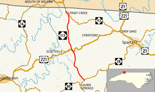
North Carolina Highway 113 is a primary state highway in the U.S. state of North Carolina. It runs from NC 18 in the community of Laurel Springs, to NC 93 in the community of Piney Creek.

North Carolina Highway 145 highway in North Carolina

North Carolina Highway 145 is a primary state highway in the U.S. state of North Carolina. It runs from the South Carolina state line to U.S. Route 74 entirely in Anson County.

North Carolina Highway 162

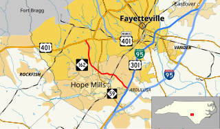
North Carolina Highway 162 (NC 162) is a primary state highway in the U.S. state of North Carolina. The highway serves as an alternate route to NC 59 by bypassing downtown Hope Mills.

North Carolina Highway 481

North Carolina Highway 481 (NC 481) is a 21-mile-long (34 km) primary state highway in the U.S. state of North Carolina. It serves to connect Enfield to nearby Interstate 95 (I-95) and the surrounding farmlands of southern Halifax County.

References

  1. 1 2 Google (June 13, 2013). "North Carolina Highway 186" (Map). Google Maps . Google. Retrieved June 13, 2013.
  2. "NC 186 Route Change (2013-05-21)" (PDF). North Carolina Department of Transportation. May 21, 2013. Retrieved June 13, 2013.
  3. Google (June 13, 2013). "North Carolina Highway 195" (Map). Google Maps . Google. Retrieved June 13, 2013.
KML file (edithelp)
    KML is from Wikidata