North Carolina Highway 46

Last updated

NC 46.svg

North Carolina Highway 46
NC 46 map.svg
Route information
Maintained by NCDOT
Length16.9 mi [1] (27.2 km)
Existed1929-1930–present
Major junctions
West endVirginia 46.svg SR 46 at the Virginia state line
 
East endUS 301.svgNC 186.svg US 301 / NC 186 in Garysburg
Location
Counties Northampton
Highway system
NC 45.svg NC 45 NC 47 NC 47.svg

North Carolina Highway 46 (NC 46) is a primary state highway in the U.S. state of North Carolina; it is entirely in Northampton County. The route primarily connects the communities on the north side of Roanoke Rapids Lake and Lake Gaston, as well as the north side of the Roanoke River in the county.

A state highway, state road, or state route is usually a road that is either numbered or maintained by a sub-national state or province. A road numbered by a state or province falls below numbered national highways in the hierarchy. Roads maintained by a state or province include both nationally numbered highways and un-numbered state highways. Depending on the state, "state highway" may be used for one meaning and "state road" or "state route" for the other.

North Carolina State of the United States of America

North Carolina is a state in the southeastern region of the United States. It borders South Carolina and Georgia to the south, Tennessee to the west, Virginia to the north, and the Atlantic Ocean to the east. North Carolina is the 28th-most extensive and the 9th-most populous of the U.S. states. The state is divided into 100 counties. The capital is Raleigh, which along with Durham and Chapel Hill is home to the largest research park in the United States. The most populous municipality is Charlotte, which is the second-largest banking center in the United States after New York City.

Northampton County, North Carolina County in the United States

Northampton County is a county located in the U.S. state of North Carolina. As of the 2010 census, the population was 22,099. Its county seat is Jackson.

Contents

Route description

NC 46 begins at its western terminus at the Virginia state line near Henrico. The road in Virginia continues north as Virginia State Route 46 towards Lawrenceville, Virginia. The two-lane roads heads east through a mostly forested area of the county, staying between one to one and a half miles (1.6 to 2.4 km) north of the Roanoke Rapids Lake shoreline. At the intersection of River Road, North Carolina Bicycle Route 4 joins to form a concurrency with NC 46 from here to Gaston. [2] There is a small cluster of homes as the road passes the settlement of Vultare. Forested areas begin to give way to a mix of farms and small single-family houses. Soon, the road enters the town of Gaston intersecting NC 48 in the center of the town. [1] This intersection marks the end of the Bike Route 4 concurrency. [2]

Virginia State of the United States of America

Virginia, officially the Commonwealth of Virginia, is a state in the Southeastern and Mid-Atlantic regions of the United States located between the Atlantic Coast and the Appalachian Mountains. Virginia is nicknamed the "Old Dominion" due to its status as the first English colonial possession established in mainland North America and "Mother of Presidents" because eight U.S. presidents were born there, more than any other state. The geography and climate of the Commonwealth are shaped by the Blue Ridge Mountains and the Chesapeake Bay, which provide habitat for much of its flora and fauna. The capital of the Commonwealth is Richmond; Virginia Beach is the most populous city, and Fairfax County is the most populous political subdivision. The Commonwealth's estimated population as of 2018 is over 8.5 million.

Henrico, North Carolina Unincorporated community in North Carolina, United States

Henrico is an unincorporated community in Northampton County, North Carolina, United States. The community is 11 miles (18 km) west-northwest of Roanoke Rapids. Henrico has a post office with ZIP code 27842.

Virginia State Route 46 highway in Virginia

State Route 46 is a primary state highway in the U.S. state of Virginia. The state highway begins at the North Carolina state line near Valentines, where the highway continues as North Carolina Highway 46. SR 46 runs 42.57 miles (68.51 km) north from the state line to SR 40 in Blackstone. The state highway serves as the main north–south highway of Brunswick County, where it intersects U.S. Route 58 in Lawrenceville and both Interstate 85 (I-85) and US 1 near Alberta.

East of NC 48, the road begins to curve to the southeast as it passes through Gaston's residential neighborhoods. The road resumes a more rural surrounding again as it passes some farms, small homes, and light industrial businesses. Before an interchange with Interstate 95 (I-95), NC 186 joins NC 46 from the north to form a concurrency for the remainder of NC 46's trip. In the vicinity of I-95's exit 176, a diamond interchange, there are few traveler services in the immediate vicinity-- only one each of a gas station, restaurant, and motel. After a short stretch of road in a rural area, NC 46 enters Garysburg passing through a mainly residential section of the town before it ends at a stop-controlled T-intersection with U.S. Route 301 (US 301). NC 186 heads north from this point along US 301 before it continues towards Virginia to the northeast. [1]

Interstate 95 (I-95) is a major Interstate Highway, running along the East Coast of the United States from Florida to Maine. In North Carolina, I-95 runs diagonally across the eastern third of the state, from Rowland at the South Carolina border to Pleasant Hill at the Virginia border. From south to north, the route passes through or near the cities of Lumberton, Fayetteville, Wilson, Rocky Mount and Roanoke Rapids. The route goes through a mostly rural area of the state, avoiding most of the major metro areas of North Carolina. It forms the informal border between the Piedmont and Coastal Plain regions of the state. There are two auxiliary routes for I-95 in the state: Future I-295, a partially completed bypass of Fayetteville and I-795, a spur route connecting I-95 to the city of Goldsboro.

North Carolina Highway 186 highway in North Carolina

North Carolina Highway 186 (NC 186) is a primary state highway in the U.S. state of North Carolina. Entirely in Northampton County, it helps facilitate truck traffic parallel to I-95 and connect the communities of Seaboard and Margarettsville.

Diamond interchange common type of road junction

A diamond interchange is a common type of road junction, used where a freeway crosses a minor road.

History

NC 46 was created between 1929 and 1930. The routing has changed very little since that time, but its eastern terminus used to be signed as US 1/US 17/US 117/NC 48/NC 481.[ citation needed ]

U.S. Route 1 in North Carolina highway in North Carolina

U.S. Route 1 (US 1) is a north–south United States highway that runs for 174.1 miles (280.2 km) from the South Carolina state line, near Rockingham, to the Virginia state line, near Wise. It serves as a strategic highway, connecting the North Carolina Sandhills and Research Triangle regions.

U.S. Route 17 in North Carolina highway in North Carolina

In the U.S. state of North Carolina U.S. Route 17 (US 17) is a north–south highway that is known as the Coastal Highway in the southeastern half of the state and the Ocean Highway in other areas. The route enters the state from South Carolina near Calabash, and leaves in the vicinity of the Great Dismal Swamp National Wildlife Refuge in Virginia. Between the US 64 freeway and the Virginia state line, US 17 is a four-lane divided highway with speed limits varying between 45 miles per hour (72 km/h) and 70 miles per hour (110 km/h).

U.S. Route 117 is a north–south United States highway that runs for 114 miles (183 km) from Wilmington to Wilson, entirely in the state of North Carolina.

Major intersections

The entire route is in Northampton County.

LocationmikmDestinationsNotes
0.00.0Virginia 46.svg SR 46 north (Christanna Highway) Lawrenceville Virginia state line
Gaston 10.416.7NC 48.svg NC 48 (Roanoke Rapids / Pleasants Hill Roads) Roanoke Rapids, Pleasant Hill
12.920.8NC 186.svg NC 186 west (Lebanon Church Road)Western end of NC 186 concurrency
13.4–
13.6
21.6–
21.9
I-95.svg I-95  Roanoke Rapids, Rocky Mount, Emporia, VA Exit 176 (I-95)
Garysburg 16.927.2US 301.svgNC 186.svgUS 158.svg US 301 / NC 186 east to US 158  Weldon, Pleasant Hill, Seaboard Eastern end of NC 186 concurrency
1.000 mi = 1.609 km; 1.000 km = 0.621 mi

Related Research Articles

U.S. Route 701 is an auxiliary route of US 1 in the U.S. states of South Carolina and North Carolina. The U.S. Highway runs 171.45 miles (275.92 km) from US 17 and US 17 Alternate in Georgetown, South Carolina north to US 301, North Carolina Highway 96, and Interstate 95 (I-95) near Four Oaks, North Carolina. US 701 serves the Pee Dee region of South Carolina and the southern and central portions of Eastern North Carolina. The highway connects Georgetown and Conway in South Carolina with the North Carolina cities of Whiteville, Elizabethtown, Clinton, and a short distance north of its terminus, Smithfield. US 701 has four business routes in North Carolina, including those through Tabor City, Whiteville, Clarkton, and Clinton.

U.S. Route 258 highway in the United States

U.S. Route 258 is a spur of US 58 in the U.S. states of North Carolina and Virginia. The U.S. Highway runs 220.15 miles (354.30 km) from US 17 Business and NC 24 Business in Jacksonville, North Carolina north to Virginia State Route 143 at Fort Monroe in Hampton, Virginia. In North Carolina, US 258 connects Jacksonville with the Inner Banks communities of Kinston, Snow Hill, Farmville, Tarboro, and Murfreesboro. The U.S. Highway continues through the Virginia city of Franklin, where the highway intersects US 58, and the town of Smithfield on its way to the Hampton Roads metropolitan area. US 258 crosses the James River on the James River Bridge and follows Mercury Boulevard through Newport News and Hampton.

North Carolina Highway 345 highway in North Carolina

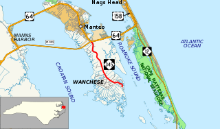
North Carolina Highway 345 (NC 345) is a primary state highway in the U.S. state of North Carolina connecting Wanchese and Manteo on Roanoke Island. The highway begins at The Lane and Thicket Lump Drive south of the town marina. Following Mill Landing Road through Wanchese, the road eventually becomes the western boundary for the Roanoke Island Marshes Dedicated Nature Preserve, before reaching its northern terminus at US 64.

North Carolina Highway 14 highway in North Carolina

North Carolina Highway 14 (NC 14) is a primary state highway in the U.S. state of North Carolina entirely in Rockingham County. It links US 29/US 158 near Reidsville with the city of Eden. From Eden, it continues north concurrent with NC 87 to the Virginia state line where the road continues as Virginia State Route 87 (SR 87).

U.S. Route 301 in Virginia highway in Virginia

U.S. Route 301 is a part of the U.S. Highway System that runs from Sarasota, Florida to Biddles Corner, Delaware. In Virginia, the U.S. Highway runs 142.70 miles (229.65 km) from the North Carolina state line near Skippers north to the Maryland state line at the Potomac River near Dahlgren. US 301 forms the local complement to Interstate 95 (I-95) from Emporia to Petersburg. The U.S. Highway runs concurrently with US 1 between Petersburg and the state capital of Richmond, where the highways form one of the main north–south avenues. US 301 continues north concurrent with Virginia State Route 2 to Bowling Green, forming an eastern alternative to I-95 and US 1 north of Richmond. At Bowling Green, which is connected to I-95 by SR 207, US 301 becomes the primary highway connecting Richmond and the Northern Neck with Southern Maryland. US 301 was constructed in four main segments: as the original SR 24 and then US 17-1 south of Petersburg, as US 1 from Petersburg to Richmond, as SR 2 from Richmond to Bowling Green, and as part of SR 207 toward Dahlgren. US 301 replaced US 17-1 in the early 1930s and was extended from Petersburg north along its current course into Maryland when the Potomac River Bridge was completed in 1940.

North Carolina Highway 96 highway in North Carolina

North Carolina Highway 96 (NC 96) is a 112-mile-long (180 km) primary state highway in the U.S. state of North Carolina. It is a predominantly rural highway that travels north-south, from NC 55, west of Newton Grove, to the Virginia state line near Virgilina, Virginia, where it continues on as Virginia State Route 96. It also connects the cities of Smithfield, Selma, Zebulon, Youngsville and Oxford.

Virginia State Route 35 highway in Virginia

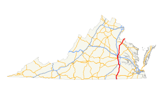
State Route 35 is a primary state highway in the U.S. state of Virginia. The state highway runs 48.71 miles (78.39 km) from the North Carolina state line near Boykins, where the highway continues as North Carolina Highway 35, north to SR 605 and SR 622 in Templeton. SR 35 is the main north–south highway of Southampton County; the highway also connects U.S. Route 58 in Courtland with Interstate 95 (I-95) and US 301 at Templeton south of Petersburg.

North Carolina Highway 27 highway in North Carolina

North Carolina Highway 27 (NC 27) is a primary state highway in the U.S. state of North Carolina. The route traverses 198 miles (319 km) through southern and central North Carolina, about 100 miles (160 km) of it as a concurrency with NC 24.

North Carolina Highway 903 highway in North Carolina

North Carolina Highway 903 (NC 903) is a primary state highway in the U.S. state of North Carolina. It serves as predominantly rural highway in the Inner Banks region and arterial road in and around Greenville. The road covers a total of 200 miles (320 km), in a zigzag pattern through the state.

U.S. Route 13 in North Carolina highway in North Carolina

The section of U.S. Route 13 in North Carolina is the longest, home to 185.52 miles (298.57 km) of its length. It runs southwest to northeast through eastern North Carolina, beginning at Interstate 95. Most of the routing is rural, serving only three cities of considerable size along the entire route; the rest passes through forests and farmland. US 13 is usually only two lanes wide unless it is co-signed with other highways, usually near cities as bypasses.

North Carolina Highway 48 highway in North Carolina

North Carolina Highway 48 (NC 48) is a primary state highway in the U.S. state of North Carolina that principally connects the cities of Rocky Mount and Roanoke Rapids. The route offers an alternative to US 301 and I-95.

U.S. Route 301 in North Carolina highway in North Carolina

U.S. Route 301 (US 301) is a north–south United States highway that runs for 194 miles (312 km) in North Carolina from the South Carolina state line near Rowland to the Virginia state line near Pleasant Hill.

North Carolina Highway 125 highway in North Carolina

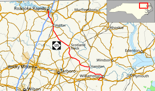
North Carolina Highway 125 (NC 125) is a primary state highway in the U.S. state of North Carolina that serves the communities of Williamston, Hamilton, Oak City, Hobgood, Scotland Neck, Halifax, and Roanoke Rapids.

South Carolina Highway 57 (SC 57) is a 25.9-mile-long (41.7 km) state highway in the northeastern part of the U.S. state of South Carolina. The highway travels in a southeast-northwest orientation from the unincorporated community of Fork northwest through Dillon to Little Rock and then curves northeasterly to the North Carolina state line, north of Little Rock, all completely within Dillon County.

North Carolina Highway 770

North Carolina Highway 770 (NC 770) is a 32-mile-long (51 km) state highway running through rural North Carolina and Eden. The road travels from NC 704 near Sandy Ridge to the Virginia state line southwest of Danville. NC 770 runs along a concurrency from Eden to the eastern terminus with U.S. Route 311. Most of the road is two lanes wide. NC 770 is one of the few North Carolina state highways numbered in the 700s.

North Carolina Highway 481

North Carolina Highway 481 (NC 481) is a 21-mile-long (34 km) primary state highway in the U.S. state of North Carolina. It serves to connect Enfield to nearby Interstate 95 (I-95) and the surrounding farmlands of southern Halifax County.

References

  1. 1 2 3 Google (February 11, 2016). "North Carolina Highway 46" (Map). Google Maps . Google. Retrieved February 11, 2016.
  2. 1 2 "North Line Trace - Bike Route 4 (DRAFT)" (PDF). North Carolina Department of Transportation. p. 8. Retrieved February 11, 2016.
KML file (edithelp)
    KML is from Wikidata