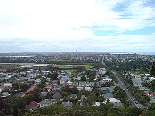
North Harbour is a suburb on the North Shore of Auckland, New Zealand. It is located 12 kilometres north of the city centre, to the south of the suburb of Albany. The suburb has not been officially designated as a suburb by Auckland Council, the territorial authority. The place name holds no official status with the New Zealand Geographic Board,[3] nor is it used by New Zealand Post.[4] North Harbour is, however, a statistical area used in Statistics New Zealand datasets and North Harbour East and North Harbour West are area units.[5] The general area that embodies what is referred to as the suburb of North Harbour is made up of parts of Albany, Rosedale, Schanpper Rock and Pinehill.
The business and light industrial area of Rosedale was given the name North Harbour Industrial Estate when construction commenced on it in the 1990s. The former North Shore City Council the changed the name of this area back to Rosedale in 2009, as a result of a broader review of suburb names and boundaries in the North Shore.[6] This area is sometimes referred to by the former name. Business North Harbour, the association responsible for the area's business improvement district, retains the place name of North Harbour in their name. Business North Harbour was unhappy with the name change to Rosedale, describing the name as a "stinker" due to the association with the Rosedale Wastewater Treatment Plant and former landfill located in the suburb.[7] Some businesses in Rosedale use North Harbour in their names and as the suburb in their addresses.
North Harbour statistical area covers 5.49km2 (2.12sqmi)[1] and had an estimated population of 790 as of June 2021,[2] with a population density of 144 people per km2.
North Harbour had a population of 816 at the 2018 New Zealand census, an increase of 252 people (44.7%) since the 2013 census, and an increase of 366 people (81.3%) since the 2006 census. There were 276 households, comprising 432 males and 387 females, giving a sex ratio of 1.12 males per female. The median age was 38.7 years (compared with 37.4 years nationally), with 84 people (10.3%) aged under 15 years, 186 (22.8%) aged 15 to 29, 366 (44.9%) aged 30 to 64, and 183 (22.4%) aged 65 or older.
Ethnicities were 64.7% European/Pākehā, 5.9% Māori, 1.1% Pacific peoples, 29.0% Asian, and 4.0% other ethnicities. People may identify with more than one ethnicity.
The percentage of people born overseas was 45.2, compared with 27.1% nationally.
Although some people chose not to answer the census's question about religious affiliation, 52.6% had no religion, 37.5% were Christian, 2.2% were Hindu, 1.8% were Muslim, 1.5% were Buddhist and 1.5% had other religions.
Of those at least 15 years old, 192 (26.2%) people had a bachelor's or higher degree, and 93 (12.7%) people had no formal qualifications. The median income was $34,900, compared with $31,800 nationally. 117 people (16.0%) earned over $70,000 compared to 17.2% nationally. The employment status of those at least 15 was that 381 (52.0%) people were employed full-time, 84 (11.5%) were part-time, and 15 (2.0%) were unemployed.[8]
Education
Albany Junior High School is a school catering for year 7-10 students, with a roll of 1143 students as at March 2022.[9][10] It was opened in 2005.[11]Albany Senior High School opened in Albany in 2009 for year 11-13 students.[12]
The North Shore is part of the large urban area of Auckland, New Zealand, located to the north of the Waitematā Harbour. To the east, has the Hauraki Gulf, to the west, is West Auckland, to the south, has the Waitematā Harbour and Central Auckland, to the north has the Hibiscus Coast. From 1989 until 2010, North Shore City was an independent city within the Auckland Region, until it was incorporated into the Auckland Council.
Onehunga is a suburb of Auckland in New Zealand and the location of the Port of Onehunga, the city's small port on the Manukau Harbour. It is eight kilometres south of the city centre, close to the volcanic cone of Maungakiekie / One Tree Hill.
Northcote is a suburb of Auckland in northern New Zealand. It is situated on the North Shore, on the northern shores of Waitematā Harbour, four km northwest of Auckland CBD. The suburb includes the peninsula of Northcote Point and the northern approaches to the Auckland Harbour Bridge. Northcote Central is to the north of Northcote.
Māngere or Mangere is one of the largest suburbs in Auckland, in northern New Zealand. It is located on mainly flat land on the northeastern shore of the Manukau Harbour, to the northwest of Manukau City Centre and 15 kilometres south of the Auckland city centre. It is the location of Auckland Airport, which lies close to the harbour's edge to the south of the suburb.
Birkenhead is a suburb of Auckland, in northern New Zealand. It is located on the North Shore of the Waitemata Harbour, four kilometres northwest of the Auckland CBD.
Takapuna is a suburb located on the North Shore of Auckland, New Zealand. The suburb is situated at the beginning of a south-east-facing peninsula forming the northern side of the Waitematā Harbour. While very small in terms of population, it was the seat of the North Shore City Council before amalgamation into Auckland Council in 2010 and contains substantial shopping and entertainment areas, acting as a CBD for the North Shore.
Glenfield is a suburb, part of the contiguous Auckland metropolitan area. It is located in the North Shore, north of the Waitemata Harbour, and Auckland is located in New Zealand.
Albany is one of the northernmost suburbs of the contiguous Auckland metropolitan area in New Zealand. It is located to the north of the Waitematā Harbour, 15 kilometres (9 mi) northwest of the Auckland city centre. The suburb is in the Albany ward, one of the thirteen administrative divisions of Auckland Council. One of the city's newest suburbs, it was until relatively recently a town in its own right, and still has a feeling of not being truly a part of the city, which lies predominantly to the southeast of it. Much of the land to the north of Albany is still semi-rural.
Kumeū is an affluent rural community situated 25 km north-west of the Auckland CBD located New Zealand. State Highway 16 and the North Auckland Line pass through the town. Huapai lies to the west, Riverhead to the north, Whenuapai to the east, and Taupaki to the south.
Ōtaki is a town in the Kapiti Coast District of the North Island of New Zealand, situated half way between the capital city Wellington, 70 km (43 mi) to the southwest, and Palmerston North, 70 km (43 mi) to the northeast.
Seatoun, an eastern suburb of Wellington, the capital city of New Zealand, lies on the east coast of the Miramar Peninsula, close to the entrance to Wellington Harbour, some seven kilometres southeast of the CBD. The suburb sits on an exposed promontory close to Barrett Reef, a dangerous area of rocky shallows upon which many ships have foundered, most notably the inter-island ferry TEV Wahine in 1968.
Forrest Hill is a suburb located on the North Shore of Auckland, New Zealand.
Greenhithe is a northwestern suburb of Auckland, New Zealand, located on the North Shore.
Massey is a north-western suburb in the city of Auckland, New Zealand. It was formerly a northern suburb of Waitakere City, which existed from 1989 to 2010 before the city was amalgamated into Auckland Council. The suburb was named after former Prime Minister of New Zealand William Massey. Massey is a relatively large suburb and can be divided into three reasonably distinctive areas, Massey West, Massey East and Massey North. Parts of Massey East are also known as 'Royal Heights', which is home to the Royal Heights shopping centre.
The Northern Busway is a segregated busway that runs along the eastern side of the Northern Motorway, part of State Highway 1, in the north of Auckland, New Zealand, linking the North Shore with the northern end of the Auckland Harbour Bridge. As of May 2022, the busway consists of two-way lanes running between Albany Station and Akoranga Station, and from Akoranga Station a southbound-only lane that joins the harbour bridge approaches just south of the Onewa Road on-ramp system. Between 2008 and 2022 the busway terminated at Constellation.
Lyall Bay is a bay and a suburb on the south side of the Rongotai isthmus in Wellington, New Zealand.
Wattle Downs is a suburb of South Auckland, New Zealand.
Campbells Bay is a suburb of the North Shore located in Auckland, New Zealand.
Rosedale is a suburb on the North Shore of Auckland, New Zealand. It is located 12 kilometres north of the city centre, to the south of the suburbs of Pinehill and Albany. It is under the local governance of the Auckland Council.
The Upper Harbour Local Board is one of the 21 local boards of the Auckland Council, and is one of the two boards overseen by the council's Albany Ward councillors.
This page is based on this Wikipedia article Text is available under the CC BY-SA 4.0 license; additional terms may apply. Images, videos and audio are available under their respective licenses.