North Hill, Minot

Last updated

North Hill
NorthHillinMinotND.png
North Hill from Downtown Minot
Coordinates: 48°15′29″N101°17′46″W / 48.258°N 101.296°W / 48.258; -101.296
CountryFlag of the United States.svg  United States
StateFlag of North Dakota.svg  North Dakota
County Ward County
City Minot
Subdistricts of North Hill
List
  • Ridgedale Industrial Park
  • • Northern Plaines Energy Park
  • • Airport Industrial Park
  • • Stonebridge Farms
  • • Prairie Wynd
  • • Statesboro
  • • Idlewild
  • • Ballantyne
  • • Northern View
  • • Tollberg Shores
  • • Northern Lights
  • • Pheasant Run
  • • Lake Side
  • • Highlands at North Hill
  • • Prairie view Estates
  • • Terrace Heights
  • • Crestview
  • • Marian Heights
  • • California Ranchos
  • • University Heights
  • • Glacial Point
  • Polaris Park
  • • Highland Acres
  • • Eagles Landing
  • • Bolton Heights
  • • Country Club Manor
Government
  Minot City CouncilBob Miller, George Withus, Dean Frantsvog, Jim Hatlelid, Amy Moen, Milton Miller
   State Assembly Robert Frantsvog (R), Matthew M. Klein (R), Larry Bellew (R), Dan Ruby (R), Roscoe Streyle (R), Andrew G. Maragos (R)
   State Senate David Hogue (R), Karen K. Krebsbach (R), Oley Larsen (R)
   U.S. House Kevin Cramer (R)
Area
[1]
  Total6.15 sq mi (15.93 km2)
Highest elevation
1,768 ft (539 m)
Lowest elevation
1,685 ft (514 m)
ZIP codes
58703
Area code 701

North Hill is a neighborhood in Minot, North Dakota, one of three major areas of the city, others being The Valley and South Hill, It is located north of the Souris River, above the Souris River Valley. It is a primarily residential neighborhood, though there are industries and businesses in the area, primarily along North Broadway and 21st Ave NW. [2] North Hill is also home to Minot International Airport.

Contents

Geography

North Hill is located north of The Valley. The neighborhood is bound by The Valley to the south and the city limits on the west, north and east. The major streets through North Hill include North Broadway, 21st Avenue NW, and 16th Street NW. All the streets in Minot are gridded, based on the intersection of Central Avenue and Main Street downtown. All of the roads in North Hill are north of Central Avenue. Main Street in North Hill divides streets east and west. Main Street, however, only exists in sections on North Hill, due to area restrictions and the airport. North Hill can most easily be accessed via the West Bypass, the Northeast Bypass, or North Broadway.

Economy

Top employers

The top employers on North Hill, according to the Minot Area Chamber EDC in March 2023: [3]

#Employer# of Employees
1 Minot Public Schools 1047
2City of Minot437
4Delta Vacations367
3 SRT Communications 218

Attractions

Parks and recreation

Optimist Park OptimistPark Minot.jpg
Optimist Park

Education

Erik Ramstad Middle School, was formerly located on Lincoln Avenue in the Souris River Valley, but was badly flooded in the Souris River flood in 2011. The school named for one of the founders of Minot, Erik Ramstad was rebuilt on North Hill. [4] In the fall of 2011, students at Ramstad Middle School began attending classes at the Minot Municipal Auditorium downtown. Temporary classroom units on the property were also needed to accommodate students. On August 23, 2012, a groundbreaking ceremony for the new school was held in North Hill for the $35 million school [5] Erik Ramstad Middle School is the only middle school on North Hill, as Jim Hill Middle School is located on South Hill and Memorial Middle School is located at the Minot Air Force Base.

Lewis & Clark Elementary School is the only elementary school on North Hill, It was built roughly in the 60s and was formerly named “North Hill Elementary School” but was later changed.

Minot North High School is also located on North Hill in the former Cognizant site and is projected to open in fall 2024. It will be Minot’s second high school. The Mouzafarov Institute of Dance and Ballet Theatre is also located on North Hill.

Transportation

The main roads through North Hill are the US 83 Bypass, the Northeast Bypass, 16th Street NE and Broadway. Broadway follows US 83 through the entire length of the city.

Minot International Airport

Magic City Bridge MagicCityBridge.jpg
Magic City Bridge

North Hill is home to Minot International Airport, the third busiest airport in the state, behind Bismarck Municipal Airport in Bismarck. In 2022, the airport had over 137,000 boardings, The airport is served by Allegiant, Delta, and United, which fly to Denver, Las Vegas, Minneapolis and Phoenix. The Magic City pedestrian bridge also connects the airport with the Grand Hotel and the west side of North Broadway.

MCT

Minot city bus Minot City Bus 2013.jpg
Minot city bus

Minot City Transit has 2 routes that serve several communities on North Hill with a 3rd route extension planned for the service. [6]

Routes that serve North Hill:

Northwest - The Northwest route serves the central and west portions of North Hill. The route serves the areas of Downtown, Upper Brooklyn, University Heights, Glacial Point, Highlands at North Hill, Terrace Heights, and Lakeview.

North Central - The North Central route serves the central and southeast portions of North Hill. The route serves the areas of Downtown, Upper Brooklyn, University Heights, Glacial Point, Polaris Park, and western portions of Lakeview.


Future development

Minot 2040 recognizes two growth areas in the area, Northwest Growth Area & Extraterritorial Growth Area.

Minot North High School is located on the former Cognizant site, it is projected to open Fall 2024. It is expected that the opening of the school will reel in more development opportunities for North Hill.


Events

Emergency Services

Hospital

St. Alexius Medical Clinic is located at 21st Ave NW

Trinity Health is located at 37th Ave SW

Related Research Articles

<span class="mw-page-title-main">Minot, North Dakota</span> City in North Dakota, United States

Minot is a city in and the county seat of Ward County, North Dakota, United States, in the state's north-central region. It is most widely known for the Air Force base approximately 15 miles (24 km) north of the city. With a population of 48,377 at the 2020 census, Minot is the state's fourth-most populous city and a trading center for a large part of northern North Dakota, southwestern Manitoba, and southeastern Saskatchewan. Founded in 1886 during the construction of James J. Hill's Great Northern Railway, Minot is also known as "Magic City", commemorating its remarkable growth in size over a short time.

<span class="mw-page-title-main">Capitol Hill, Seattle</span> Neighborhood in Seattle, Washington, United States

Capitol Hill is a densely populated residential district in Seattle, Washington, United States. One of the city's most popular nightlife and entertainment districts, it is home to a historic gay village and vibrant counterculture community.

<span class="mw-page-title-main">Kansas City metropolitan area</span> Metropolitan statistical area in the United States

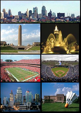
The Kansas City metropolitan area is a bi-state metropolitan area anchored by Kansas City, Missouri. Its 14 counties straddle the border between the U.S. states of Missouri and Kansas. With 8,472 square miles (21,940 km2) and a population of more than 2.2 million people, it is the second-largest metropolitan area centered in Missouri and is the largest metropolitan area in Kansas, though Wichita is the largest metropolitan area centered in Kansas. Alongside Kansas City, Missouri, these are the suburbs with populations above 100,000: Overland Park, Kansas; Kansas City, Kansas; Olathe, Kansas; Independence, Missouri; and Lee's Summit, Missouri.

<span class="mw-page-title-main">Edgewater, Chicago</span> Community area in Chicago

Edgewater is a lakefront community area on the North Side of the city of Chicago, Illinois six miles north of the Loop. The most recently established of the city's 77 official community areas, Edgewater is bounded by Foster Avenue on the south, Devon Avenue on the north, Ravenswood Avenue on the west, and Lake Michigan on the east. Edgewater contains several beaches that residents enjoy during the late spring, summer, and early autumn. Chicago's largest park, Lincoln Park, stretches south from Edgewater for seven miles along the waterfront, almost to downtown. Historically, Edgewater was the northeastern corner of Lake View Township, an independent suburb annexed by the city of Chicago in 1889. Today, the Uptown community is to Edgewater's south, Lincoln Square to its west, West Ridge to its northwest and Rogers Park to its north.

<span class="mw-page-title-main">Rockridge, Oakland, California</span> Neighborhood of Oakland in Alameda, California, US

<span class="mw-page-title-main">Minot Public Schools</span>

Minot Public Schools (MPS) is a system of publicly funded K-12 schools in Minot, North Dakota. There are thirteen elementary schools, three middle schools, and a high school on three campuses. Three schools are located on Minot AFB, fifteen miles north. Minot City Transit provides busing service.

Erik Reiersen Ramstad was one of the founders of Minot, North Dakota.

Minot City Transit, is the public transit agency operated in Minot, North Dakota, It operates fixed-route bus routes in the city.

<span class="mw-page-title-main">Neighborhoods in Spokane, Washington</span>

Neighborhoods in Spokane, Washington are officially grouped by the Spokane City Council into three main city council districts: 1, 2, and 3. Each city council district contains multiple, official neighborhoods that are recognized with a neighborhood council. Informally, neighborhoods are colloquially grouped by local geographical, geological, cultural, or historical features The list of neighborhoods below is organized based on the official designations by the City of Spokane. Unofficial neighborhoods and districts are listed within the official neighborhood in which they are located.

The City of Oklahoma City uses Special Zoning Districts as a tool to maintain the character of many neighborhood communities.

The geography of Minot, North Dakota is treated extensively in this article.

<span class="mw-page-title-main">Sections of Billings, Montana</span>

The city of Billings, Montana is subdivided into 11 sections for geographic and planning purposes.

<span class="mw-page-title-main">Downtown Minot</span> Place in North Dakota, United States

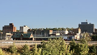
Downtown Minot is the central business district of Minot, North Dakota, located south of the Souris River in the Souris Valley. Downtown is the site of the first permanent settlement in Minot in 1886. Downtown is home to many of Minot's cultural sites of interest. It is also home to numerous galleries, stores and restaurants. The Minot Riverwalk traverses the downtown.

<span class="mw-page-title-main">Bel Air, Minot</span> Place in North Dakota, United States

Bel Air is a neighborhood in Minot, North Dakota, located in the Souris River Valley. It is roughly bound by North Hill to the north, Sixteenth Street NW to the east, Fourth Avenue NW to the south and the city limits on the west. The neighborhood was home to about a thousand people in 2010. The neighborhood is home to Bel Air Elementary School on Twenty Fifth Street NW. The neighborhood was developed as the Bel Air Addition in 1956. Fourth Avenue is home to a number of businesses in Bel Air, many of which were severely damaged in the Souris River flood in 2011. Bel Air is home to the Church of the Living God, the Bible Fellowship Church and the Christ Lutheran Church.

<span class="mw-page-title-main">South Hill, Minot</span> Place in North Dakota, United States

South Hill is a neighborhood in Minot, North Dakota, one of three major areas in the city, others being North Hill and The Valley, it is located south of the Souris River, above the Souris River Valley. It is a primarily residential neighborhood, although there are commercial zones along South Broadway, 20th Ave SW, 37th Ave SW, and around the Dakota Square Mall.

<span class="mw-page-title-main">Upper Brooklyn</span>

Upper Brooklyn or Brooklyn Heights is a neighborhood on South Hill in Minot, North Dakota. The neighborhood consists of the sections of the Brooklyn Addition that are not part of Downtown Minot. The High Third neighborhood, the Lower Brooklyn neighborhood and the area around the Minot Municipal Auditorium, which were part of the Brooklyn Addition, are considered part of the downtown area. Upper Brooklyn is bordered by downtown and the BNSF railroad tracks to the north, Minot High School's Magic City Campus to the west, Eleventh Avenue SW to the south and South Broadway and Lower Brooklyn to the east. The neighborhood is approximately 0.46 square kilometers. The neighborhood is home to the Scandinavian Heritage Park and Jim Hill Middle School.

<span class="mw-page-title-main">Transportation in Buffalo, New York</span>

Transportation in Buffalo, New York is dominated by automobile use, but other modes of transportation exist in the city.

<span class="mw-page-title-main">West Central, Spokane</span> Neighborhood in Spokane, Washington, U.S.

West Central is a neighborhood in Spokane, Washington. As the name suggests it is located centrally on the west side of the city. Downtown Spokane is immediately east of the neighborhood, and spreads into West Central along Monroe Street in the Kendall Yards area. The neighborhood is diverse, with single and multi-family residential zones dating back to the early days of Spokane, a new mixed use development on the site of a former rail yard, the Spokane County Courthouse campus and associated government buildings and a few commercial districts. The Spokane River gorge winds around the southern and western edge of the neighborhood. It is home to Nettleton's Addition Historic District, which was added to the National Register of Historic Places in March 2006, and is also the largest historic district on the Washington State Heritage Register.

<span class="mw-page-title-main">Emerson/Garfield, Spokane</span> Spokane Neighborhood in Washington, United States

Emerson/Garfield is a neighborhood in Spokane, Washington. It is located immediately north of Downtown Spokane's North Bank and extends out into the inner northwestern portion of the city. Emerson/Garfield is a diverse neighborhood with residential, commercial and civic zones all bordering one another, with density ranging from single-family homes to multi-use buildings. Due to its location in the central area of Spokane, Emerson/Garfield is criss-crossed by numerous arterials and thoroughfares. Along those main roads are numerous commercial and retail districts of importance to both the neighborhood and city as a whole.

<span class="mw-page-title-main">North Hill, Spokane</span> Spokane Neighborhood in Washington, United States

North Hill is a neighborhood in Spokane, Washington. As the name suggests, it is atop a hill on the north side of Spokane, within which it is centrally located and crossed by numerous major thoroughfares. It is home to parks, commercial districts and single family residential areas. The historic Garland Theater is located in North Hill, and the city's main north–south arterial, Division Street, is home to a major commercial district along the eastern edge of the neighborhood.

References

  1. "Downtown Los Angeles neighborhood in Los Angeles, California (CA), 90012, 90013, 90014, 90015, 90021 subdivision profile - real estate, apartments, condos, homes, community, population, jobs, income, streets".
  2. "Minot Zoning Map" (PDF). Archived from the original (PDF) on January 5, 2012. Retrieved March 15, 2013.
  3. "Minot's Top Employers 1st Quarter, 2013" (PDF). 2013. Archived from the original (PDF) on March 4, 2016. Retrieved March 20, 2013.
  4. Digital Minot: Ramstad Future Archived 2013-04-09 at archive.today
  5. Johnson, Andrea. "Students Help Break Ground for New Ramstad". Minot Daily News. August 24, 2012.
  6. Minot City Transit Archived 2013-08-15 at the Wayback Machine , accessed March 15, 2013