
Northumberland is a ceremonial county in North East England, bordering Scotland. It is bordered by the Scottish Borders to the north, the North Sea to the east, Tyne and Wear and County Durham to the south, and Cumbria to the west. The town of Blyth is the largest settlement.

The Shropshire Hills are a dissected upland area and one of the natural regions of England. They lie wholly within the county of Shropshire and encompass several distinctive and well-known landmarks, such as the Long Mynd, Wenlock Edge, The Wrekin and the Clees.
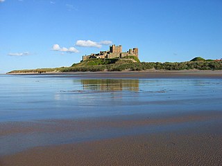
The Northumberland Coast National Landscape is a designated Area of Outstanding Natural Beauty (AONB) covering 40 miles (64 km) of coastline from Berwick-Upon-Tweed to the River Coquet estuary in the Northeast of England. Features include: Alnmouth, Bamburgh, Beadnell, Budle Bay, Cocklawburn Beach, Craster, Dunstanburgh Castle, the Farne Islands, Lindisfarne and Seahouses. It lies within the natural region of the North Northumberland Coastal Plain.

The Cheviot Hills, or sometimes The Cheviots, are a range of uplands straddling the Anglo-Scottish border between Northumberland and the Scottish Borders. The English section is within the Northumberland National Park. The range includes The Cheviot, plus Hedgehope Hill to the east, Windy Gyle to the west, and Cushat Law and Bloodybush Edge to the south.

Lindisfarne National Nature Reserve is a 3,541-hectare (8,750-acre) UK national nature reserve. It was founded to help safeguard the internationally important wintering bird populations, and six internationally important species of wildfowl and wading birds winter here. For the pale-bellied brent geese from Svalbard, this is their only regular wintering place in all of the United Kingdom. Pinkfooted and greylag geese, wigeons, grey plovers and bar-tailed godwits are the other visitors.

The Dorset Heaths form an important area of heathland within the Poole Basin in southern England. Much of the area is protected.
A National Character Area (NCA) is a natural subdivision of England based on a combination of landscape, biodiversity, geodiversity and economic activity. There are 159 National Character Areas and they follow natural, rather than administrative, boundaries. They are defined by Natural England, the UK government's advisors on the natural environment.
The South Coast Plain is a natural region in England running along the central south coast in the counties of East and West Sussex and Hampshire.

The Marshwood and Powerstock Vales form a natural region in southwest England reaching to the Dorset coastline.

The Yeovil Scarplands are a natural region in southern England in the counties of Somerset and Dorset.

The Northumberland Sandstone Hills are a major natural region in the English county of Northumberland. The hills form distinctive skylines with generally level tops, northwest facing scarps and craggy outcrops offering views to the Cheviots further west.

The Mid Severn Sandstone Plateau is a rural landscape and one of the natural regions of central England, straddling the border between the counties of Shropshire and Staffordshire. It stretches from the western fringes of the Birmingham conurbation to Telford in the north and Kidderminster in the south. The major feature of the plateau is the valley of the River Severn, which cuts through it from north to south. It consists of Permian and Triassic-age New Red Sandstone getting older as one goes west until one reaches Silurian and Carboniferous-age siltstones and coals west of the river.

The Devon Redlands is a natural region in southwest Britain that has been designated as National Character Area (NCA) 148 by Natural England.
The geology of Northumberland in northeast England includes a mix of sedimentary, intrusive and extrusive igneous rocks from the Palaeozoic and Cenozoic eras. Devonian age volcanic rocks and a granite pluton form the Cheviot massif. The geology of the rest of the county is characterised largely by a thick sequence of sedimentary rocks of Carboniferous age. These are intruded by both Permian and Palaeogene dykes and sills and the whole is overlain by unconsolidated sediments from the last ice age and the post-glacial period. The Whin Sill makes a significant impact on Northumberland's character and the former working of the Northumberland Coalfield significantly influenced the development of the county's economy. The county's geology contributes to a series of significant landscape features around which the Northumberland National Park was designated.
The geology of Northumberland National Park in northeast England includes a mix of sedimentary, intrusive and extrusive igneous rocks from the Palaeozoic and Cenozoic eras. Devonian age volcanic rocks and a granite pluton form the Cheviot massif. The geology of the rest of the national park is characterised largely by a thick sequence of sedimentary rocks of Carboniferous age. These are intruded by Permian dykes and sills, of which the Whin Sill makes a significant impact in the south of the park. Further dykes were intruded during the Palaeogene period. The whole is overlain by unconsolidated sediments from the last ice age and the post-glacial period.

Northumbria, in modern contexts, usually refers to the region of England between the Tees and Tweed, including the historic counties of Northumberland and Durham, but it may also be taken to be synonymous with North East England. The area corresponds to the rump lands of the historical Kingdom of Northumbria, which later developed into the late medieval county of Northumberland or Comitatus Northumbriae, whose original southern boundary was the River Tees. A provincial flag of Northumbria has been registered.
Cheviot Fringe is a geographical region and a Natural England designated National Character Area located in the county Northumberland in northern England. The region consists of the undulating lowlands between the Cheviot Hills and the Northumberland Sandstone Hills NCA. Three major rivers flow through the region, it is bounded on the north by the River Tweed and on the south by the River Coquet and the River Till flows through the middle.
Mid Northumberland NCA is a National Character Area in Northern England between the Northumberland Sandstone Hills and the North Northumberland Coastal Plain. It is bordered to the south by the Hadrian's Wall World Heritage Site. Ridges and river valleys dominate the region in the northern and western regions, where the NCA borders the uplands in northwestern Northumberland; lowlands and plains dominate the landscape in the south as the land rolls toward the Tyneside Lowlands.

The Northumberland Coast Path is a long distance path in Northumberland in northern England. It now forms part of the England Coast Path.
