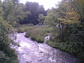
North York River | |
Country | Canada |
---|---|
Province | Ontario |
Region | Central Ontario |
County | Haliburton |
Municipality | Highlands East |
Part of | Great Lakes Basin |
Source | Little Branch Lake |
- elevation | 416 m (1,365 ft) |
- coordinates | 45°18′10″N78°13′34″W / 45.30278°N 78.22611°W |
Mouth | York River |
- elevation | 394 m (1,293 ft) |
- coordinates | 45°14′24″N78°14′12″W / 45.24000°N 78.23667°W Coordinates: 45°14′24″N78°14′12″W / 45.24000°N 78.23667°W |
The North York River is a river in the municipality of Dysart et al, Haliburton County in Central Ontario, Canada. [1] It is in the southern extension of Algonquin Provincial Park, is in the Saint Lawrence River drainage basin, and is a left tributary of the York River.
A river is a natural flowing watercourse, usually freshwater, flowing towards an ocean, sea, lake or another river. In some cases a river flows into the ground and becomes dry at the end of its course without reaching another body of water. Small rivers can be referred to using names such as stream, creek, brook, rivulet, and rill. There are no official definitions for the generic term river as applied to geographic features, although in some countries or communities a stream is defined by its size. Many names for small rivers are specific to geographic location; examples are "run" in some parts of the United States, "burn" in Scotland and northeast England, and "beck" in northern England. Sometimes a river is defined as being larger than a creek, but not always: the language is vague.
The United Townships of Dysart, Dudley, Harcourt, Guilford, Harburn, Bruton, Havelock, Eyre and Clyde, commonly known as the Municipality of Dysart et al, is a municipality in Haliburton County in Central Ontario, Canada. The original townships were of the Canadian Land and Emigration Company. At 61 letters or 68 non-space characters, the municipality has the longest name of any place in Canada.
Haliburton is a county of Ontario, Canada, known as a tourist and cottage area in Central Ontario for its scenery and for its resident artists. Minden Hills is the county seat. Haliburton County and the village of Haliburton are named after Thomas Chandler Haliburton, author, statesman, and the first chairman of the Canadian Land and Emigration Company.
The river originates at Little Branch Lake in geographic Clyde Township. It flows southeast, south and west to Billings Lake in geographic Bruton Township. The river then heads south and reaches the York River just upstream of Branch Lake. The York River flows via the Madawaska River and Ottawa River to the Saint Lawrence River.
Little Branch Lake is a lake in Haliburton County, Ontario, Canada in the southern extension of Algonquin Park and is the source of the North York River.
Branch Lake is a lake in Haliburton County, Ontario, Canada in the southern extension of Algonquin Park. The York River flows into and exits from the lake. The North York River joins the York River at the lake.
The Madawaska River is a river in the Saint Lawrence River drainage basin in Ontario, Canada. The river is 230 km (143 mi) long and drains an area of 8,470 km2 (3,270 sq mi). Its name comes from an Algonquian band of the region known as "Matouweskarini", meaning "people of the shallows".
The Indian River is a river in Lanark County in Eastern Ontario, Canada. It is in the Saint Lawrence River drainage basin and is a left tributary of the Mississippi River.
The York River is a river in Renfrew County, Hastings County and Haliburton County in Ontario, Canada. The river is in the Saint Lawrence River drainage basin, and flows from the southern extension of Algonquin Provincial Park to the Madawaska River.
The Indian River is river in Renfrew County and Nipissing District in Eastern and Northeastern Ontario, Canada. It is in the Saint Lawrence River drainage basin, and is a left tributary of the Muskrat River.
The Talbot River is a river in the Great Lakes Basin in Central Ontario, Canada which flows from Mitchell Lake to Lake Simcoe and forms the border between Simcoe County to the north and the Regional Municipality of Durham to the south from the river mouth to the edge of their border with the city of Kawartha Lakes at the east.
Cedar Lake is a lake in the geographic townships of Boyd, Deacon and Lister in the Unorganized south part of Nipissing District in northeastern Ontario, Canada. The lake is in the Saint Lawrence River drainage basin and is entirely within Algonquin Provincial Park; it is a popular entry point for canoe trips into the interior of the park as the community of Brent, located on the lake, is connected by Brent Road to Ontario Highway 17. Other places on the lake are Acanthus and Government Park.
The Clyde River is a river in Lanark County in Eastern Ontario, Canada. It is in the Saint Lawrence River drainage basin, is a left tributary of the Mississippi River, and was named after the River Clyde in Scotland.
Source Lake is a small lake in geographic Canisbay and Peck townships in the Unorganized South part of Nipissing District in Northeastern Ontario, Canada. It lies in southern Algonquin Provincial Park and is part of the Saint Lawrence River drainage basin. The river is the source of the Madawaska River, which flows via the Ottawa River to the Saint Lawrence River.
The Crow River is a river in the Saint Lawrence River drainage basin in the Unorganized South Part of Nipissing District in northeastern Ontario, Canada. The river lies entirely within Algonquin Provincial Park and is a right tributary of the Petawawa River.
The Nipissing River is a river in the Saint Lawrence River drainage basin in the Unorganized South Part of Nipissing District in northeastern Ontario, Canada. The river is entirely within Algonquin Provincial Park, and is a left tributary of the Petawawa River.
The Blanche River is a river in the Saint Lawrence River drainage basin in Timiskaming District in northeastern Ontario, Canada. The river is a tributary of Lake Timiskaming and its name is from the French for the colour "white".
Bobs Lake is a lake in Frontenac County and Lanark County in Eastern Ontario, Canada. It is in the St. Lawrence River drainage basin and is the source of the Tay River.
Centennial Lake is a reservoir lake in the Township of Greater Madawaska, Renfrew County and the Township of North Frontenac, Frontenac County in Eastern Ontario, Canada. It is on the Madawaska River and is part of the Saint Lawrence River drainage basin.
Norcan Lake is a reservoir lake in the municipality of North Frontenac, Frontenac County in Eastern Ontario, Canada. It is on the Madawaska River system, is part of the Saint Lawrence River drainage basin, and is located in geographic townships of North Canonto Township and South Canonto Township.
The Little Clyde River is a river in the municipality of Lanark Highlands, Lanark County in Eastern Ontario, Canada. It is in the Saint Lawrence River drainage basin, is a right tributary of the Clyde River, and was named after the River Clyde in Scotland.
Depot Creek is a river in Nipissing District in Northeastern Ontario, Canada. It is in the Saint Lawrence River drainage basin, is a tributary of Grand Lake on the Barron River, and lies entirely within Algonquin Provincial Park.
The Little Jocko River is a river in Nipissing District in Northeastern Ontario, Canada. It is in the Saint Lawrence River drainage basin, is a right tributary of the Jocko River, and lies entirely within Jocko Rivers Provincial Park.
Sucker Lake is a lake in geographic La Salle Township and geographic Osborne Township in the Unorganized North Part of Nipissing District in Northeastern Ontario, Canada, about 5.5 kilometres (3.4 mi) east of the railway point of Diver on the Ontario Northland Railway. It is in the Saint Lawrence River drainage basin and is the source of Sucker Creek.
Mud Lake is a lake in Greater Madawaska, Renfrew County in Eastern Ontario, Canada. It is in geographic Brougham Township, is part of the Saint Lawrence River drainage basin, and is the source of Little Black Donald Creek.
Mud Lake is a lake in Greater Madawaska, Renfrew County in Eastern Ontario, Canada. It is in geographic Blithfield Township, and is part of the Saint Lawrence River drainage basin.
The Ministry of Transportation of Ontario (MTO) is the provincial ministry of the Government of Ontario that is responsible for transport infrastructure and related law in Ontario. The ministry traces its roots back over a century to the 1890s, when the province began training Provincial Road Building Instructors. In 1916, the Department of Public Highways of Ontario (DPHO) was formed and tasked with establishing a network of provincial highways. The first was designated in 1918, and by the summer of 1925, sixteen highways were numbered. In the mid-1920s, a new Department of Northern Development (DND) was created to manage infrastructure improvements in northern Ontario; it merged with the Department of Highways of Ontario (DHO) on April 1, 1937. In 1971, the Department of Highways took on responsibility for Communications and in 1972 was reorganized as the Ministry of Transportation and Communications (MTC), which then became the Ministry of Transportation in 1987.
The Ministry of Municipal Affairs and Housing is the department of the Government of Ontario that is responsible for municipal affairs and housing in the Canadian province of Ontario.
This article related to a river in Ontario, Canada is a stub. You can help Wikipedia by expanding it. |