York River (Ontario)

Last updated
York River
Egan Chute ON.JPG
Egan Chute on the York River, near Bancroft
Canada Southern Ontario relief location map.jpg
Red pog.svg
Location of the mouth of the York River in southern Ontario
Location
Country Canada
Province Ontario
Regions
Counties
Physical characteristics
Source Yorkend Lake
  location Dysart et al, Haliburton County, Central Ontario
  coordinates 45°18′01″N78°20′21″W / 45.30028°N 78.33917°W / 45.30028; -78.33917
  elevation497 m (1,631 ft)
Mouth Madawaska River
  location
Madawaska Valley, Renfrew County, Eastern Ontario
  coordinates
45°20′08″N77°34′43″W / 45.33556°N 77.57861°W / 45.33556; -77.57861 Coordinates: 45°20′08″N77°34′43″W / 45.33556°N 77.57861°W / 45.33556; -77.57861
  elevation
283 m (928 ft)
Basin features
River system Saint Lawrence River drainage basin

The York River is a river in Renfrew County, Hastings County and Haliburton County in Ontario, Canada. [1] [2] The river is in the Saint Lawrence River drainage basin, and flows from the southern extension of Algonquin Provincial Park to the Madawaska River.

Contents

Course

The river begins in the southern extension of Algonquin Provincial Park at Yorkend Lake, in geographic Clyde Township in the municipality of Dysart et al, Haliburton County. [2] It flows west out of the park through geographic Eyre Township and Harburn Township, then loops back east into the southernmost part of the park in geographic Bruton Township. It takes in the left tributary North York River just before Branch Lake, turns southeast, passes over the High Falls, and exits the park into Benoir Lake. It continues east into Baptiste Lake where it enters geographic Herschel Township [3] in the municipality of Hastings Highlands, Hastings County. The river leaves the lake south at the lake's southeast tip, controlled by the Ontario Ministry of Natural Resources-operated Baptiste Lake Dam, [4] enters the town of Bancroft, and passes over the Bancroft Light & Power Generating Station and dam. The river is crossed by Ontario Highway 28 and Ontario Highway 62 in the town centre, then turns east and northeast. It is crossed again by Ontario Highway 28, passes over Egan Chute and Fram Chute at Egan Chutes Provincial Park, [5] and briefly reenters Hastings Highlands at geographic Monteagle Township. [6] The rivers continues northeast into geographic Carlow Township in the municipality of Carlow/Mayo, passes over the Conroy Rapids and enters the Conroy Marsh, a 24 km2 (9 sq mi) provincially significant wetland. As the river flows through the marsh, it first passes into the municipality of Brudenell, Lyndoch and Raglan, Renfrew County, then takes in the right tributary Little Mississippi River. The river then reaches its mouth as a right tributary of the Madawaska River in geographic Radcliffe Township [7] in the municipality of Madawaska Valley, near the community of Mayhews Landing. The Madawska River flows via the Ottawa River to the Saint Lawrence River.
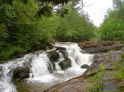
History

In the second half of the 19th century, the river was used to transport logs out of the forests surrounding its watershed. Now, parts of this river have been turned into a provincial waterway park as well as a provincial nature reserve (at Egan Chute).

Natural history

The river alternates between fast flowing portions in steep sided gorges to slower movement through post-glacial sand flats. In these are changes in the river course has created ox-bows and abandoned ox-bows that are now ponds and wetlands.

Group of Seven artist A. J. Casson painted a number of scenes from this region, including one titled "Conroy Marsh" and several along the York River itself.

Iron foot-bridge over the York river, in the town of Bancroft Iron Bridge by SillyPuttyEnemies.jpg
Iron foot-bridge over the York river, in the town of Bancroft

Waterfalls

Tributaries

See also

Related Research Articles

Madawaska River (Ontario)

The Madawaska River is a river in the Saint Lawrence River drainage basin in Ontario, Canada. The river is 230 km (143 mi) long and drains an area of 8,470 km2 (3,270 sq mi). Its name comes from an Algonquian band of the region known as "Matouweskarini", meaning "people of the shallows".

Indian River (Muskrat River watershed)

The Indian River is a river in Renfrew County and Nipissing District in Eastern and Northeastern Ontario, Canada. It is in the Saint Lawrence River drainage basin, and is a left tributary of the Muskrat River.

Petawawa River

The Petawawa River is a river in the Saint Lawrence River drainage basin in Nipissing District and Renfrew County in eastern and northeastern Ontario, Canada. The river flows from Algonquin Provincial Park to the Ottawa River at the town of Petawawa, and is only one of two major tributaries of the Ottawa River to flow completely free. The river's name comes from the Algonquian for "where one hears a noise like this", which refers to its many rapids.

Bonnechere River

The Bonnechere River is a river in the Saint Lawrence River drainage basin in Nipissing District and Renfrew County in eastern and northeastern Ontario, Canada. The river flows from Algonquin Provincial Park to the Ottawa River east and north of the town of Renfrew. The river's name is thought to come from the French "bonne chère" meaning "good cheer".

Opeongo River

The Opeongo River is a river in the Saint Lawrence River drainage basin in Nipissing District in northeastern Ontario, Canada. The river is entirely within Algonquin Provincial Park and Opeongo River Provincial Park, except for a small portion around Victoria Lake, and is a left tributary of the Madawaska River.

Barron River (Ontario)

The Barron River is a river in the Saint Lawrence River drainage basin in Nipissing District and Renfrew County, Ontario, Canada. It flows from Clemow Lake in northern Algonquin Provincial Park and joins the Petawawa River, whose southern branch it forms, in the municipality of Laurentian Hills, near the municipality of Petawawa.

Source Lake is a small lake in geographic Canisbay and Peck townships in the Unorganized South part of Nipissing District in Northeastern Ontario, Canada. It lies in southern Algonquin Provincial Park and is part of the Saint Lawrence River drainage basin. The river is the source of the Madawaska River, which flows via the Ottawa River to the Saint Lawrence River.

The North York River is a river in the municipality of Dysart et al, Haliburton County in Central Ontario, Canada. It is in the southern extension of Algonquin Provincial Park, is in the Saint Lawrence River drainage basin, and is a left tributary of the York River.

Opeongo Hills

The Opeongo Hills are a range of hills in Southern Ontario, near Algonquin Provincial Park. The hills stretch from Opeongo Lake in Algonquin Park in the west, along the Madawaska and Opeongo Rivers, towards the Opeongo Colonization Road, and extending towards the Deacon Escarpment, Bonnechere, Ontario, and Dacre in the east. To the east of the Opeongo Hills lie the Madawaska River valley, the Mississippi River Valley, and the Ottawa-Bonnechere Graben along the Ottawa River. Its tallest peak is roughly 7 km northeast of Highway 60. At roughly 586 meters, it is the tallest point in Southern Ontario. The community of Foymount is one of the highest settlements in Southern Ontario.

Odenback is an unincorporated place and former railway point in geographic Deacon Township in the Unorganized South Part of Nipissing District in northeastern Ontario, Canada. Odenback is located within Algonquin Provincial Park on Radiant Lake at the confluence of the tributary Little Madawaska River with the Petawawa River.

The Crow River is a river in the Saint Lawrence River drainage basin in the Unorganized South Part of Nipissing District in northeastern Ontario, Canada. The river lies entirely within Algonquin Provincial Park and is a right tributary of the Petawawa River.

The Little Madawaska River is a river in the Saint Lawrence River drainage basin in the Unorganized South Part of Nipissing District in northeastern Ontario, Canada. The river is entirely within Algonquin Provincial Park, and is a right tributary of the Petawawa River and not a tributary of the nearby Madawaska River.

The Nipissing River is a river in the Saint Lawrence River drainage basin in the Unorganized South Part of Nipissing District in northeastern Ontario, Canada. The river is entirely within Algonquin Provincial Park, and is a left tributary of the Petawawa River.

The Tim River is a river in the Saint Lawrence River drainage basin in the Unorganized South Part of Nipissing District in northeastern Ontario, Canada. The river is entirely within Algonquin Provincial Park, and is a left tributary of the Petawawa River.

The Big East River is a river in Muskoka District and Nipissing District in Northeastern Ontario, Canada. The river is in the Great Lakes Basin, is a left tributary of the Muskoka River, and flows from Algonquin Provincial Park to Huntsville.

The Irondale River is a river in Haliburton County in Central Ontario, Canada. It is part of the Great Lakes Basin, and is a left tributary of the Burnt River.

Owaissa Lake is a lake in geographic Preston Township, Nipissing District in Northeastern Ontario, Canada. It is in Algonquin Provincial Park and is part of the Saint Lawrence River drainage basin.

Allen Creek is a stream in the municipality of Dysart et al, Haliburton County in Central Ontario, Canada. It is a tributary of Benoir Lake and is in the Ottawa River drainage basin.

Weepine Lake is a small lake in the municipality of Dysart et al, Haliburton County in Central Ontario, Canada. It is within Algonquin Provincial Park and is part of the Ottawa River drainage basin.

Fourcorner Lake is a lake in the municipality of Dysart et al, Haliburton County in Central Ontario, Canada. It is partly within Algonquin Provincial Park and is in the Ottawa River drainage basin. The lake takes its name from its location at a quadripoint, the junction point of four geographic townships: Harburn at northwest, Bruton at the northeast, Harcourt at the southeast, and Dudley at the southwest.

References

  1. "York River". Geographical Names Data Base . Natural Resources Canada . Retrieved 2012-10-21.
  2. 1 2 "York River". Atlas of Canada . Natural Resources Canada. 2010-02-04. Retrieved 2012-10-21. Shows the course of the river highlighted on a topographic map.
  3. "Herschel" (PDF). Geology Ontario - Historic Claim Maps. Ontario Ministry of Northern Development, Mines and Forestry . Retrieved 2012-10-21.
  4. "Madawaska River Water Management Plan" (PDF). Ontario Ministry of Natural Resources / Ontario Power Generation. December 2009. Retrieved 2012-10-21.
  5. "Egan Chutes". Ontario Parks. 2003-02-27. Retrieved 2012-10-21.
  6. "Monteagle" (PDF). Geology Ontario - Historic Claim Maps. Ontario Ministry of Northern Development, Mines and Forestry . Retrieved 2012-10-21.
  7. "Radcliffe" (PDF). Geology Ontario - Historic Claim Maps. Ontario Ministry of Northern Development, Mines and Forestry . Retrieved 2012-10-21.

Sources