Brudenell, Lyndoch and Raglan

Last updated

Brudenell, Lyndoch and Raglan
Township of Brudenell, Lyndoch and Raglan
Latchford Bridge ON.JPG
Near Latchford Bridge
Renfrew locator map 2021.svg
Red pog.svg
Brudenell, Lyndoch and Raglan
Canada Southern Ontario location map 2.png
Red pog.svg
Brudenell, Lyndoch and Raglan
Coordinates: 45°19′N77°24′W / 45.317°N 77.400°W / 45.317; -77.400
Country Flag of Canada (Pantone).svg  Canada
Province Flag of Ontario.svg  Ontario
County Renfrew
EstablishedJanuary 1, 2000
Government
  MayorValerie Jahn
  Federal riding (federal electoral district)|Renfrew—Nipissing—Pembroke
  Prov. riding (provincial electoral district)|Renfrew—Nipissing—Pembroke
Area
[1]
  Land706.24 km2 (272.68 sq mi)
Population
 (2016) [1]
  Total1,503
  Density2.1/km2 (5/sq mi)
Time zone UTC-5 (EST)
  Summer (DST) UTC-4 (EDT)
Postal Code FSA
K0J
Area code(s) 613, 343
Website www.blrtownship.ca

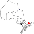
Brudenell, Lyndoch and Raglan is a township in Renfrew County, Ontario, Canada. It was formed on January 1, 1999, through the merger of Brudenell and Lyndoch Township with Raglan Township.

Contents

Communities

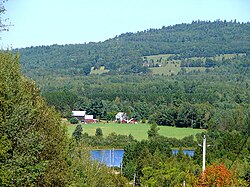
The township comprises the smaller communities of Bruceton, Brudenell, Copp, Hardwood Lake, Harriets Corners, Jewellville, Latchford Bridge, Letterkenny, Lost Nation, Palmer Rapids, Quadeville, Rockingham, Schutt, Wingle and Wolfe.

Demographics

In the 2021 Census of Population conducted by Statistics Canada, Brudenell, Lyndoch and Raglan had a population of 1,552 living in 694 of its 998 total private dwellings, a change of 3.3% from its 2016 population of 1,503. With a land area of 701.29 km2 (270.77 sq mi), it had a population density of 2.2/km2 (5.7/sq mi) in 2021. [2]

Canada census – Brudenell, Lyndoch and Raglan community profile
2021 2016 2011
Population1,552 (+3.3% from 2016)1,503 (-9.3% from 2011)1,658 (10.8% from 2006)
Land area701.29 km2 (270.77 sq mi)706.24 km2 (272.68 sq mi)705.83 km2 (272.52 sq mi)
Population density2.2/km2 (5.7/sq mi)2.1/km2 (5.4/sq mi)2.3/km2 (6.0/sq mi)
Median age55.6 (M: 56.0, F: 55.6)53.5 (M: 54.0, F: 52.8)
Private dwellings998 (total)  694 (occupied)963 (total) 1031 (total) 
Median household income$62,000$51,072
References: 2021 [3] 2016 [4] 2011 [5] earlier [6] [7]

Mother tongue (2006): [8]

Population trend: [9] [1]

Notable stories

"Al Capone's Hideout", an Upper Madawaska Theatre Group production, is a musical comedy based on the story of Al Capone's stay in the area in 1942, when he and his gang allegedly hid out near Quadeville, Ontario. [10]

See also

Related Research Articles

<span class="mw-page-title-main">North Grenville</span> Municipality in Ontario, Canada

North Grenville is a township in eastern Ontario, Canada, in the United Counties of Leeds and Grenville on the Rideau River. It is located just south of Ottawa in Canada's National Capital Region.

<span class="mw-page-title-main">Montague, Ontario</span> Township in Ontario, Canada

Montague is a township in eastern Ontario, Canada, in Lanark County on the Rideau River. The township administrative offices are located on Roger Stevens Drive east of Smiths Falls.

<span class="mw-page-title-main">Renfrew County</span> County in Ontario, Canada

Renfrew County is a county in the Canadian province of Ontario. It stands on the west bank of the Ottawa River. There are 17 municipalities in the county.

<span class="mw-page-title-main">Carling, Ontario</span> Township in Ontario, Canada

Carling is a township in Ontario, Canada, located in the District of Parry Sound on Georgian Bay. Killbear Provincial Park is located in the municipality.

<span class="mw-page-title-main">Marmora and Lake</span> Municipality in Ontario, Canada

Marmora and Lake is a municipality along the banks of Crowe River and Beaver Creek, about midway between Toronto and Ottawa on provincial Highway 7 in Hastings County in Central Ontario, Canada. It is home to over 4,000 full time and seasonal residents, many of whom enjoy outdoor recreation and relaxation on Crowe Lake.

<span class="mw-page-title-main">McNab/Braeside</span> Township in Ontario, Canada

McNab/Braeside is a township in eastern Ontario, Canada, on the south shore of Chats Lake, straddling the lower Madawaska River in Renfrew County.

<span class="mw-page-title-main">Rainy River District</span> District in Ontario, Canada

Rainy River District is a district and census division in Northwestern Ontario in the Canadian province of Ontario. It was created in 1885. It is the only division in Ontario that lies completely in the Central Time Zone, except for the township of Atikokan observing Eastern Standard Time for part of the year. Its seat is Fort Frances. It is known for its fishing and its location on the US border opposite International Falls, Minnesota, and Baudette, Minnesota.

<span class="mw-page-title-main">Brockton, Ontario</span> Municipality in Ontario, Canada

Brockton is a municipality in the Canadian province of Ontario, located in Bruce County. As of 2016, the population was 9,461.

<span class="mw-page-title-main">Evanturel</span> Township in Ontario, Canada

Évanturel is a township in Timiskaming District, Ontario, Canada. It almost completely surrounds the town of Englehart. The main settlement in Évanturel is the community of Heaslip.

<span class="mw-page-title-main">Tyendinaga, Ontario</span> Township in Ontario, Canada

Tyendinaga is a township in the Canadian province of Ontario, located in Hastings County. The community takes its name from a variant spelling of Mohawk leader Joseph Brant's traditional Mohawk name, Thayendanegea.

<span class="mw-page-title-main">Hastings Highlands</span> Municipality in Ontario, Canada

Hastings Highlands is a township in the Canadian province of Ontario.

<span class="mw-page-title-main">Opasatika</span> Township in Ontario, Canada

Opasatika is a township in the Canadian province of Ontario, located in the Cochrane District on the Opasatika River, a tributary of the Missinaibi River. Its name is of First Nation origin, meaning "river lined with poplars".

<span class="mw-page-title-main">McKellar, Ontario</span> Township in Ontario, Canada

McKellar is a township and census subdivision in Parry Sound District, Ontario, Canada. The 2021 population was 1,419.

<span class="mw-page-title-main">South Algonquin</span> Township municipality in Ontario, Canada

South Algonquin is a township municipality in Nipissing District, Ontario, Canada. Located south of Algonquin Provincial Park, it is the sole populated portion of the district that lies south of the traditional dividing line between Northern Ontario and Southern Ontario and is closer connected to Renfrew County as opposed to the core portions of Nipissing District.

<span class="mw-page-title-main">North Algona Wilberforce</span> Township municipality in Ontario, Canada

North Algona Wilberforce is a township municipality in Renfrew County, Ontario, Canada. It has a population of 2,873. The township was formed in 1999 when the North Algona and Wilberforce townships were amalgamated.

<span class="mw-page-title-main">Madawaska Valley, Ontario</span> Township in Ontario, Canada

The Township of Madawaska Valley is a township municipality in Renfrew County, Ontario, Canada. It was formed in 2001 through the amalgamation of the village of Barry's Bay and the townships of Radcliffe and Sherwood Jones & Burns. It includes the settlements of Combermere and Wilno.

<span class="mw-page-title-main">Greater Madawaska</span> Township municipality in Ontario, Canada

Greater Madawaska is an incorporated township in Renfrew County in eastern Ontario, Canada, created on January 1, 2001, through the amalgamation of the Township of Bagot and Blythfield; the Township of Brougham; and the Township of Griffith and Matawatchan. As of 2011, it has a population of 2,518.

<span class="mw-page-title-main">Harley, Ontario</span> Township in Ontario, Canada

Harley is a township in the Canadian province of Ontario. Located within the Timiskaming District, Harley is located directly north of the city of Temiskaming Shores.

<span class="mw-page-title-main">Faraday, Ontario</span> Township in Ontario, Canada

Faraday is a township in the Canadian province of Ontario, located within Hastings County adjacent to the town of Bancroft.

<span class="mw-page-title-main">Brudenell</span> Community in Ontario, Canada

Brudenell is a community in the township of Brudenell, Lyndoch and Raglan in Renfrew County, Ontario, Canada.

References

  1. 1 2 3 "Census Profile, 2016 Census: Brudenell, Lyndoch and Raglan, Township". Statistics Canada . Retrieved June 4, 2019.
  2. "Population and dwelling counts: Canada, provinces and territories, census divisions and census subdivisions (municipalities), Ontario". Statistics Canada. February 9, 2022. Retrieved April 2, 2022.
  3. "2021 Community Profiles". 2021 Canadian Census . Statistics Canada. February 4, 2022. Retrieved 2023-10-19.
  4. "2016 Community Profiles". 2016 Canadian Census . Statistics Canada. August 12, 2021. Retrieved 2018-02-19.
  5. "2011 Community Profiles". 2011 Canadian Census . Statistics Canada. March 21, 2019. Retrieved 2012-02-13.
  6. "2006 Community Profiles". 2006 Canadian Census . Statistics Canada. August 20, 2019.
  7. "2001 Community Profiles". 2001 Canadian Census . Statistics Canada. July 18, 2021.
  8. Statistics Canada 2006 Census - Brudenell, Lyndoch and Raglan community profile
  9. Statistics Canada: 1996, 2001, 2006, 2011, 2016 census
  10. "The Pembroke Library History Project". www.pembrokelibrary.ca. Archived from the original on 2011-07-06.