Horton | |
|---|---|
| Township of Horton | |
 Municipal building | |
 Horton  Horton | |
| Coordinates: 45°30′N76°40′W / 45.500°N 76.667°W | |
| Country | Canada |
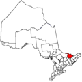
| Province | Ontario |
| County | Renfrew |
| Incorporated | 1850 |
| Government | |
| • Mayor | Daina Proctor |
| • Governing body | Horton Council |
| • MP | Cheryl Gallant |
| • MPP | Billy Denault |
| Area | |
| • Land | 158.02 km2 (61.01 sq mi) |
| Population (2021) [1] | |
• Total | 3,182 |
| • Density | 20.1/km2 (52/sq mi) |
| Time zone | UTC-5 (EST) |
| • Summer (DST) | UTC-4 (EDT) |
| Area codes | 613, 343 |
| Website | www |
Horton is a township in eastern Ontario, Canada, at the confluence of the Bonnechere River and the Ottawa River in Renfrew County. The Town of Renfrew was originally part of Horton Township.