Bonnechere River

Last updated
Bonnechere River
Bonnechère River
Bonnecherreriver.jpg
Bonnechere River in Renfrew with low water level
Canada Southern Ontario relief location map.jpg
Red pog.svg
Location of the mouth of the Bonnechere River in southern Ontario
Etymologyfrom the French "bonne chère" meaning "good eating"
Location
CountryCanada
Province Ontario
Regions
County/District
Physical characteristics
SourceMcKaskill Lake
  locationGeographic Clancy Township, Unorganized South Part, Nipissing District, Northeastern Ontario
  coordinates 45°45′01″N78°03′35″W / 45.75028°N 78.05972°W / 45.75028; -78.05972
  elevation371 m (1,217 ft)
Mouth Ottawa River
  location
Horton, Renfrew County, Eastern Ontario
  coordinates
45°31′11″N76°33′28″W / 45.51972°N 76.55778°W / 45.51972; -76.55778
  elevation
72 m (236 ft)
Length145 km (90 mi)
Basin size2,400 km2 (930 sq mi)
Basin features
Progression Ottawa RiverSt. Lawrence RiverGulf of St. Lawrence
River system Ottawa River drainage basin

The Bonnechere River is a river in the Saint Lawrence River drainage basin in Nipissing District and Renfrew County in eastern and northeastern Ontario, Canada. [1] [2] The river flows from Algonquin Provincial Park to the Ottawa River east and north of the town of Renfrew. The river's name is thought to come from the French "bonne chère" meaning "good cheer".

Contents

Geography

The Renfrew Museum along the Bonnechere River in Renfrew Renfrew Ontario.JPG
The Renfrew Museum along the Bonnechere River in Renfrew

The Bonnechere River begins in Algonquin Provincial Park at McKaskill Lake in geographic Clancy Township in the Unorganized South Part of Nipissing District. [2] It heads north into geographic Niven Township, then loops back southeast into Clancy Township, under a Hydro One transmission corridor and into geographic Guthrie Township. It continues southeast through the Crooked Chute, over the High Falls, through the Stacks Rapids to the unincorporated place Basin Depot, located on a former logging road.

The river continues southeast out of the park at Boundary access point (Access point Q), enters geographic Burns Township in Madawaska Valley, Renfrew County, then heads into geographic Richards Township in Killaloe, Hagarty and Richards, Renfrew County, takes in the left tributary Pine River, passes through the Jack Chute Rapids, and reaches Round Lake, where it takes in the right tributary Sherwood River. The rivers leaves the lake at Grassy Bay controlled by the Round Lake Dam and reaches Golden Lake in North Algona Wilberforce, where it is crossed by Ontario Highway 60. The lake is home to Killaloe at the west and the Algonquins of Pikwàkanagàn First Nation at the southeast.

From Golden Lake until the river reaches Admaston/Bromley downstream, the river forms the boundary between North Algona Wilberforce (left bank, on the north) and Bonnechere Valley (right bank, on the south). The Bonnechere River leaves Golden Lake controlled by the Golden Lake Dam.

The river reaches its mouth at Lac des Chats on the Ottawa River near the settlement of Fergusons Beach.

The river is 145 kilometres (90 mi) long and drains an area of 2,400 square kilometres (927 sq mi).

The Chutes

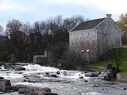
There are five chutes along the Bonnechere River. The First Chute of the river is where the Bonnechere empties into the Ottawa River, at Castleford. The Second Chute is in Renfrew; this waterfall has a small hydroelectric dam. The Third Chute is in Douglas, which also has a small hydroelectric dam. The Fourth Chute is in the small village of Fourth Chute, and the Fifth Chute is in Eganville. The chutes used were for moving timber past rapids and waterfalls.

Tributaries

  • Golden Lake
    • Scharfe Creek (left)
    • Eadys Creek (left)
    • Beaudrys Creek (left)
    • Browns Creek (left)
    • Sauers Creek (left)
    • Cochrane Creek (left)
    • Brennans Creek (right)
  • Round Lake
    • Turners Creek (left)
    • Reserve Creek (left)
    • Jacks Creek (left)
    • Sherwood River (right)
    • Byers Creek (right)
  • Pine River (left)
  • Robitaille Creek (right)
  • Dupuis Creek (left)
  • Hogan Creek (right)
  • Jenkins Creek (left)
  • Batise Creek (left)
  • Gross Creek (left)
  • McGuire Creek (right)
  • North Bonnechere River (left)
  • Fairy Creek (left)

Economy

During the 19th century, the river was used to transport white pine logs from the forested areas surrounding the river. A number of hydroelectric plants have been built on the river.

Natural history

Bonnechere Caves, Eganville, 1959 Bonnechere Caves, Eganville (I0005683).tif
Bonnechere Caves, Eganville, 1959

The Bonnechère Caves, formed from ancient limestone, are located by the river near the village of Eganville, Ontario, in the hamlet of Fourth Chute, Ontario. [3]

There are two provincial parks along its length: the Bonnechere River Provincial Park (a 23 km long section bordering Algonquin Park) and the Bonnechere Provincial Park (located on Round Lake).

The Bonnechere River lies mostly in a 175 million year old rift valley called the Ottawa-Bonnechere Graben.

Over the years, songs have been written about the Bonnechere River including the recent "In The Arms Of The Bonnechere River" by Ottawa Valley singer/songwriter, Terry McLeish.

River run

Each year the river is host to a raft run between the third and fourth chute. Originally arranged by local Shriners, the run has taken on a less official status, occurring with little to no organization apart from its pre-determined date during Victoria Day weekend. Participants design and build a raft or anything else they hope will take them down the river. The river presents natural obstacles in the form of light rapids. There is no competitive angle to the run with no prize at the end other than warmth and a good time. Most participants are young adults from the area returning to visit friends and family. Having recently surpassed its twenty-fourth year, the river run is a local tradition.

See also

Related Research Articles

<span class="mw-page-title-main">Madawaska River (Ontario)</span> River in Ontario, Canada

The Madawaska River is a river in the Saint Lawrence River drainage basin in Ontario, Canada. The river is 230 km (143 mi) long and drains an area of 8,470 km2 (3,270 sq mi). Its name comes from an Algonquian band of the region known as "Matouweskarini", meaning "people of the shallows".

<span class="mw-page-title-main">York River (Ontario)</span> River in Ontario, Canada

The York River is a river in Renfrew County, Hastings County and Haliburton County in Ontario, Canada. The river is in the Saint Lawrence River drainage basin, and flows from the southern extension of Algonquin Provincial Park to the Madawaska River.

<span class="mw-page-title-main">Indian River (Muskrat River watershed)</span> River in Ontario, Canada

The Indian River is a river in Renfrew County and Nipissing District in Eastern and Northeastern Ontario, Canada. It is in the Saint Lawrence River drainage basin, and is a left tributary of the Muskrat River.

<span class="mw-page-title-main">Petawawa River</span> River in Ontario, Canada

The Petawawa River is a river in the Saint Lawrence River drainage basin in Nipissing District and Renfrew County in eastern and northeastern Ontario, Canada. The river flows from Algonquin Provincial Park to the Ottawa River at the town of Petawawa, and is only one of two major tributaries of the Ottawa River to flow completely free. The river's name comes from the Algonquian for "where one hears a noise like this", which refers to its many rapids.

<span class="mw-page-title-main">Opeongo River</span> River in Ontario, Canada

The Opeongo River is a river in the Saint Lawrence River drainage basin in Nipissing District in northeastern Ontario, Canada. The river is entirely within Algonquin Provincial Park and Opeongo River Provincial Park, except for a small portion around Victoria Lake, and is a left tributary of the Madawaska River.

Lake Doré is a freshwater lake in the township of North Algona-Wilberforce, Renfrew County, Ontario, Canada, about 6 kilometres (3.7 mi) north of the community of Eganville in the neighbouring township of Bonnechere Valley.

<span class="mw-page-title-main">Barron River (Ontario)</span> River in Ontario, Canada

The Barron River is a river in the Saint Lawrence River drainage basin in Nipissing District and Renfrew County, Ontario, Canada. It flows from Clemow Lake in northern Algonquin Provincial Park and joins the Petawawa River, whose southern branch it forms, in the municipality of Laurentian Hills, near the municipality of Petawawa.

King's Highway 60, commonly referred to as Highway 60, is a provincially maintained highway in the Canadian province of Ontario. The 255.8-kilometre (158.9 mi) highway serves as the primary corridor through Algonquin Provincial Park, where it is dedicated as the Frank McDougall Parkway. East of Algonquin Park, the route serves east–west traffic in the highlands of central Ontario. It begins at Highway 11 in Huntsville and ends at Highway 17 near Renfrew.

<span class="mw-page-title-main">Algonquins of Pikwàkanagàn First Nation</span> Indian reserve in Ontario, Canada

The Algonquins of Pikwàkanagàn First Nation, formerly known as the Golden Lake First Nation, are an Algonquin First Nation in Ontario, Canada. Their territory is located in the former township of South Algona in the Ottawa Valley on Golden Lake.

<span class="mw-page-title-main">Eganville, Ontario</span> Unincorporated community in Ontario, Canada

Eganville is a community occupying a deep limestone valley carved at the Fifth Chute of the Bonnechere River in Renfrew County, Ontario, Canada. Eganville lies within the township of Bonnechere Valley.

The Ottawa, Arnprior and Parry Sound Railway, or OA&PS, is a historic railway that operated in central and eastern Ontario, Canada from 1897 until 1959. It was, for a time, the busiest railway route in Canada, carrying both timber and wood products from today's Algonquin Provincial Park areas, as well as up to 40% of the grain traffic from the Canadian west from Depot Harbour at Parry Sound through to the St. Lawrence River valley.

<span class="mw-page-title-main">Bonnechere Valley</span> Township municipality in Ontario, Canada

Bonnechere Valley is a township municipality in Renfrew County, Ontario, Canada. It had a population of 3,674 in the Canada 2016 Census. It was established in 2001 by amalgamation of the village of Eganville and the townships of Grattan, Sebastapol and South Algona.

<span class="mw-page-title-main">North Algona Wilberforce</span> Township municipality in Ontario, Canada

North Algona Wilberforce is a township municipality in Renfrew County, Ontario, Canada. It has a population of 2,873. The township was formed in 1999 when the North Algona and Wilberforce townships were amalgamated.

<span class="mw-page-title-main">Round Lake (Ontario)</span>

Round Lake is a lake located in Killaloe, Hagarty and Richards Township, Renfrew County, Ontario, Canada. The Bonnechere River flows into the lake in the northwest and flows out of the lake at the southeast.

<span class="mw-page-title-main">Opeongo Hills</span>

The Opeongo Hills are a range of hills in Southern Ontario, near Algonquin Provincial Park. The hills stretch from Opeongo Lake in Algonquin Park in the west, along the Madawaska and Opeongo Rivers, towards the Opeongo Colonization Road, and extending towards the Deacon Escarpment, Bonnechere, Ontario, and Dacre in the east. To the east of the Opeongo Hills lie the Madawaska River valley, the Mississippi River Valley, and the Ottawa-Bonnechere Graben along the Ottawa River. Its tallest peak is roughly 7 km northeast of Highway 60. At roughly 586 meters, it is the tallest point in Southern Ontario. The community of Foymount is one of the highest settlements in Southern Ontario.

The Crow River is a river in the Saint Lawrence River drainage basin in the Unorganized South Part of Nipissing District in northeastern Ontario, Canada. The river lies entirely within Algonquin Provincial Park and is a right tributary of the Petawawa River.

The Little Madawaska River is a river in the Saint Lawrence River drainage basin in the Unorganized South Part of Nipissing District in northeastern Ontario, Canada. The river is entirely within Algonquin Provincial Park, and is a right tributary of the Petawawa River and not a tributary of the nearby Madawaska River.

The Nipissing River is a river in the Saint Lawrence River drainage basin in the Unorganized South Part of Nipissing District in northeastern Ontario, Canada. The river is entirely within Algonquin Provincial Park, and is a left tributary of the Petawawa River.

Black Donald Lake is a reservoir lake in the Township of Greater Madawaska, Renfrew County, and the Township of North Frontenac, Frontenac County, in Eastern Ontario, Canada. It is on the Madawaska River and is part of the Saint Lawrence River drainage basin.

<span class="mw-page-title-main">Big East River</span> River in Canada

The Big East River is a river in Muskoka District and Nipissing District in Northeastern Ontario, Canada. The river is in the Great Lakes Basin, is a left tributary of the Muskoka River, and flows from Algonquin Provincial Park to Huntsville.

References

  1. "Bonnechere River". Geographical Names Data Base . Natural Resources Canada . Retrieved 2011-08-11.
  2. 1 2 "Bonnechere River". Atlas of Canada . Natural Resources Canada. 2010-02-04. Retrieved 2011-08-11. Shows the river course highlighted on a topographic map.
  3. "Bonnechere Caves".

Sources

Commons-logo.svg Media related to Bonnechere River at Wikimedia Commons