North Algona Wilberforce

Last updated

North Algona Wilberforce
Township of North Algona Wilberforce
Golden Lake ON.JPG
Golden Lake community centre and Post Office (K0J 1X0)
Renfrew locator map 2021.svg
Red pog.svg
North Algona Wilberforce
Canada Southern Ontario location map 2.png
Red pog.svg
North Algona Wilberforce
Coordinates: 45°37′06″N77°13′13″W / 45.61833°N 77.22028°W / 45.61833; -77.22028 [2]
CountryFlag of Canada (Pantone).svg  Canada
ProvinceFlag of Ontario.svg  Ontario
County Renfrew
FormedJanuary 1, 1999
Government
  MayorJames Brose
  Federal riding Renfrew—Nipissing—Pembroke
  Prov. riding Renfrew—Nipissing—Pembroke
Area
[3]
  Land378.98 km2 (146.32 sq mi)
Population
 (2016) [3]
  Total2,915
  Density7.7/km2 (20/sq mi)
Time zone UTC-5 (EST)
  Summer (DST) UTC-4 (EDT)
Postal Code
K0J 1T0
Area code(s) 613, 343
Website www.nalgonawil.com OOjs UI icon edit-ltr-progressive.svg

North Algona Wilberforce is a township municipality in Renfrew County, Ontario, Canada. [2] [4] It has a population of 2,873. The township was formed in 1999 [2] when the North Algona and Wilberforce townships were amalgamated.

Contents

Wilberforce Township was named in 1851, to honour William Wilberforce.

Communities

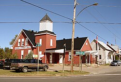
The township contains the communities of Allans Corners, Beef Town, Budd Mills, Crooked Rapids, Deacon, Dore Bay, Duquette's Farm, Fourth Chute, Germanicus, Golden Lake, Green Lake, Higginson's Hill, Lake Dore, Lett's Corners, Mink Lake, Mud Lake, [5] [4] Rankin, Slabtown, Trevor Ouellette Lake and Woito.

Fourth Chute

The town of Fourth Chute is the fourth of five chutes along the Bonnechere River. The others being Castleford, Renfrew, Douglas and Eganville. The chutes used were for moving timber past rapids and waterfalls.

Transportation

Canadian National Railway served Golden Lake on the Algonquin and Locksley subdivisions. Rail service was discontinued in 1961 on the Locksley Subdivision. The Algonquin Subdivision was broken in 1933 due to an unsafe trestle in the Algonquin Park at Cache Lake. The section east of the break became the Renfrew Subdivision, which maintained service until 1984. The grades of both lines now serve at trails for snow machines, ATVs and bicycles.

The township is served by Ontario Highway 41 and Ontario Highway 60. [4] [6]

Demographics

In the 2021 Census of Population conducted by Statistics Canada, North Algona Wilberforce had a population of 3,111 living in 1,297 of its 1,757 total private dwellings, a change of 6.7% from its 2016 population of 2,915. With a land area of 369.23 km2 (142.56 sq mi), it had a population density of 8.4/km2 (21.8/sq mi) in 2021. [7]

Canada census – North Algona Wilberforce community profile
2021 2016 2011
Population3,111 (+6.7% from 2016)2915 (1.5% from 2011)2873 (1.2% from 2006)
Land area369.23 km2 (142.56 sq mi)378.98 km2 (146.32 sq mi)378.53 km2 (146.15 sq mi)
Population density8.4/km2 (22/sq mi)7.7/km2 (20/sq mi)7.6/km2 (20/sq mi)
Median age52 (M: 51.2, F: 52.8)51.5 (M: 50.4, F: 52.5)
Private dwellings1,295 (total) 1752 (total) 1668 (total) 
Median household income
References: 2021 [8] 2016 [9] 2011 [10] earlier [11] [12]
North Algona Wilberforce
historical populations
YearPop.±%
1996 2,595    
2001 2,729+5.2%
2006 2,840+4.1%
2011 2,873+1.2%
2016 2,915+1.5%
[13]

Mother tongue: [3]

See also

Related Research Articles

<span class="mw-page-title-main">Lanark County</span> County in Ontario, Canada

Lanark County is a county located in the Canadian province of Ontario. Its county seat is Perth, which was first settled in 1816.

<span class="mw-page-title-main">Indian River (Muskrat River watershed)</span> River in Ontario, Canada

The Indian River is a river in Renfrew County and Nipissing District in Eastern and Northeastern Ontario, Canada. It is in the Saint Lawrence River drainage basin, and is a left tributary of the Muskrat River.

<span class="mw-page-title-main">Horton, Ontario</span> Township in Ontario, Canada

Horton is a township in eastern Ontario, Canada, at the confluence of the Bonnechere River and the Ottawa River in Renfrew County. The Town of Renfrew was originally part of Horton Township.

<span class="mw-page-title-main">Bonnechere River</span> River in Ontario, Canada

The Bonnechere River is a river in the Saint Lawrence River drainage basin in Nipissing District and Renfrew County in eastern and northeastern Ontario, Canada. The river flows from Algonquin Provincial Park to the Ottawa River east and north of the town of Renfrew. The river's name is thought to come from the French "bonne chère" meaning "good cheer".

Lake Doré is a freshwater lake in the township of North Algona-Wilberforce, Renfrew County, Ontario, Canada, about 6 kilometres (3.7 mi) north of the community of Eganville in the neighbouring township of Bonnechere Valley.

<span class="mw-page-title-main">Head, Clara and Maria</span> Township in Ontario, Canada

Head, Clara and Maria, officially the United Townships of Head, Clara and Maria, is a municipality and incorporated township in Renfrew County in eastern Ontario, Canada, It is on the Ottawa River and on the northern edge of Algonquin Park.

<span class="mw-page-title-main">Admaston/Bromley</span> Township in Ontario, Canada

Admaston/Bromley is an incorporated township in Renfrew County, Eastern Ontario, Canada. It was formed on January 1, 2000, when Admaston and Bromley Townships were amalgamated. It takes part of its name from Admaston, Staffordshire, a small English hamlet.

<span class="mw-page-title-main">Renfrew—Nipissing—Pembroke (federal electoral district)</span> Federal electoral district in Ontario, Canada

Renfrew—Nipissing—Pembroke is a federal electoral district in Ontario, Canada, that has been represented in the House of Commons since 1979.

<span class="mw-page-title-main">Laurentian Valley</span> Township municipality in Ontario, Canada

Laurentian Valley is a township municipality in Renfrew County in eastern Ontario, Canada. It borders on the Ottawa River, the city of Pembroke and the town of Petawawa.

The Snake River is a river in Renfrew County, Ontario, Canada.

<span class="mw-page-title-main">South River, Ontario</span> Village in Ontario, Canada

South River is a village on Highway 124 near Algonquin Park in the Almaguin Highlands region of Parry Sound District of Ontario, Canada. It is about halfway between North Bay and Huntsville or a 3-hour drive (300 km) north from Toronto. South River has access to the Algonquin Park for canoeists at Kawawaymog. South River is home of Mikisew Provincial Park on the shores of Eagle Lake.

<span class="mw-page-title-main">Fauquier-Strickland</span> Township in Ontario, Canada

Fauquier-Strickland is a township municipality in Cochrane District in Northeastern Ontario, Canada. The three main communities in the township are Fauquier, Strickland, and Gregoires Mill. All are located along Ontario Highway 11 between the community of Departure Lake to the east and the municipality of Moonbeam to the west.

<span class="mw-page-title-main">South Algonquin</span> Township municipality in Ontario, Canada

South Algonquin is a township municipality in Nipissing District, Ontario, Canada. Located south of Algonquin Provincial Park, it is the sole populated portion of the district that lies south of the traditional dividing line between Northern Ontario and Southern Ontario and is closer connected to Renfrew County as opposed to the core portions of Nipissing District.

<span class="mw-page-title-main">Golden Lake</span>

Golden Lake is a body of water located in Renfrew County Ontario, located on the Bonnechere River approximately 25 km southwest of Pembroke, Ontario. It is bounded by the Township of North Algona-Wilberforce, the Township of Bonnechere Valley and Algonquins of Pikwàkanagàn First Nation.

<span class="mw-page-title-main">Bonnechere Valley</span> Township municipality in Ontario, Canada

Bonnechere Valley is a township municipality in Renfrew County, Ontario, Canada. It had a population of 3,674 in the Canada 2016 Census. It was established in 2001 by amalgamation of the village of Eganville and the townships of Grattan, Sebastapol and South Algona.

<span class="mw-page-title-main">Greater Madawaska</span> Township municipality in Ontario, Canada

Greater Madawaska is an incorporated township in Renfrew County in eastern Ontario, Canada, created on January 1, 2001, through the amalgamation of the Township of Bagot and Blythfield; the Township of Brougham; and the Township of Griffith and Matawatchan. As of 2011, it has a population of 2,518.

<span class="mw-page-title-main">Algonquin Highlands</span> Township in Ontario, Canada

Algonquin Highlands is a township located in Haliburton County, Ontario, Canada. It has a population of 2,351. The northeastern section of the township is included in Algonquin Provincial Park.

<span class="mw-page-title-main">James, Ontario</span> Township in Ontario, Canada

James is an incorporated township in the Canadian province of Ontario, located in Timiskaming District. The primary community within the township is Elk Lake, which is located at the junction of Ontario Highway 65 and Ontario Highway 560.

<span class="mw-page-title-main">Chamberlain, Ontario</span> Township in Ontario, Canada

Chamberlain is a township in the Canadian province of Ontario, located within the Timiskaming District.

<span class="mw-page-title-main">Opeongo Hills</span>

The Opeongo Hills are a range of hills in Southern Ontario, near Algonquin Provincial Park. The hills stretch from Opeongo Lake in Algonquin Park in the west, along the Madawaska and Opeongo Rivers, towards the Opeongo Colonization Road, and extending towards the Deacon Escarpment, Bonnechere, Ontario, and Dacre in the east. To the east of the Opeongo Hills lie the Madawaska River valley, the Mississippi River Valley, and the Ottawa-Bonnechere Graben along the Ottawa River. Its tallest peak is roughly 7 km northeast of Highway 60. At roughly 586 meters, it is the tallest point in Southern Ontario. The community of Foymount is one of the highest settlements in Southern Ontario.

References

  1. "List of Ontario municipalities". Ontario Ministry of Municipal Affairs and Housing. 2021-05-11. Retrieved 2022-01-13.
  2. 1 2 3 "North Algona Wilberforce". Geographical Names Data Base . Natural Resources Canada . Retrieved 2022-01-13.
  3. 1 2 3 "North Algona Wilberforce census profile". 2016 Census of Population . Statistics Canada. Retrieved 2019-02-25.
  4. 1 2 3 "Ontario Geonames GIS (on-line map and search)". Ontario Ministry of Natural Resources and Forestry. 2020. Retrieved 2022-01-11.
  5. "Mud Lake". Geographical Names Data Base . Natural Resources Canada . Retrieved 2022-01-11.
  6. Map 10 (PDF) (Map). 1 : 700,000. Official road map of Ontario. Ministry of Transportation of Ontario. 2020-01-01. Retrieved 2022-01-13.
  7. "Population and dwelling counts: Canada, provinces and territories, census divisions and census subdivisions (municipalities), Ontario". Statistics Canada. February 9, 2022. Retrieved April 2, 2022.
  8. "2021 Community Profiles". 2021 Canadian Census . Statistics Canada. February 4, 2022. Retrieved 2022-04-27.
  9. "2016 Community Profiles". 2016 Canadian Census . Statistics Canada. August 12, 2021. Retrieved 2019-02-25.
  10. "2011 Community Profiles". 2011 Canadian Census . Statistics Canada. March 21, 2019. Retrieved 2012-02-13.
  11. "2006 Community Profiles". 2006 Canadian Census . Statistics Canada. August 20, 2019.
  12. "2001 Community Profiles". 2001 Canadian Census . Statistics Canada. July 18, 2021.
  13. Statistics Canada: 1996, 2001, 2006, 2011, 2016 census