Dysart et al, Ontario

Last updated

Dysart et al
United Townships of Dysart, Dudley, Harcourt, Guilford, Harburn, Bruton, Havelock, Eyre and Clyde
Haliburton ON 2.JPG
Motto: 
Confidently yet cautiously
Haliburton locator map 2021.svg
Red pog.svg
Dysart et al
Canada Southern Ontario location map 2.png
Red pog.svg
Dysart et al
Coordinates: 45°12′N78°25′W / 45.200°N 78.417°W / 45.200; -78.417
CountryFlag of Canada (Pantone).svg  Canada
ProvinceFlag of Ontario.svg  Ontario
County Haliburton
Settled1860s
IncorporatedJanuary 7, 1867
Government
  TypeTownship
  MayorMurray Fearrey
  Federal riding Haliburton—Kawartha Lakes—Brock
  Prov. riding Haliburton—Kawartha Lakes—Brock
Area
[1]
  Land1,485.98 km2 (573.74 sq mi)
Population
 (2016) [1]
  Total6,280
  Density4.2/km2 (11/sq mi)
Time zone UTC-5 (EST)
  Summer (DST) UTC-4 (EDT)
Postal Code
K0M
Area code(s) 705, 249
Website www.dysartetal.ca

The United Townships of Dysart, Dudley, Harcourt, Guilford, Harburn, Bruton, Havelock, Eyre and Clyde, commonly known as the Municipality of Dysart et al, is a municipality in Haliburton County in Central Ontario, Canada. [2] [3] [4] The original townships were of the Canadian Land and Emigration Company.

Contents

Longest place name

At 61 letters or 68 non-space characters, the municipality had the longest name of any place in Canada for a long time. [5] However, in 2010 it was far surpassed by the newly created local service district of Lethbridge, Morley's Siding, Brooklyn, Charleston, Jamestown, Portland, Winter Brook and Sweet Bay in Newfoundland and Labrador. [6] [7]

The municipality still has the status of longest place name of mainland Canada, longest place name of Ontario and second longest place name of Canada.

Etymologies

Communities

Haliburton's main street Haliburton ON 1.JPG
Haliburton's main street

The municipality's primary town is Haliburton ( 45°02′50″N78°30′30″W / 45.04722°N 78.50833°W / 45.04722; -78.50833 ), a community on Head Lake. Haliburton has a seasonal tourism-based economy. Some of southern Ontario's population retreats to central and northern Ontario "cottage country" for recreation and relaxation during the summer.

Haliburton Village and Haliburton County derive their name from the author Thomas Chandler Haliburton, who wrote the popular "Sam Slick" stories in the mid-19th century. Haliburton was chairman of the Board of Directors of The British Land and Immigration Company in England, who were responsible for developing most of the area before it became incorporated into a "Provisional County" in 1887.

The municipality also includes the smaller communities of Donald, Eagle Lake, Fort Irwin, Goulds, Harburn, Harcourt, [4] Kennaway (ghost town), [9] [10] Kennisis Lake and West Guilford.

History

In the 1860s, the Canadian Land and Emigration Company of London, England purchased 360,000 acres (150,000 ha) in this part of Ontario for settlement purposes. The development was named after company chairman Judge Thomas Haliburton, a politician and the author of the Sam Slick stories. [11] [12] According to the historical book, "Fragments of a Dream: Pioneering in Dysart Township and Haliburton Village" by Leopolda z L. Dobrzensky, the first European settlers began arriving in Haliburton village in 1864. Key settlers included Captain John Lucas (1824–1874). Lucas co-established the first saw/grist mill and was later elected the first Reeve of Dysart. Captain Lucas, originally a native of Long Preston, Yorkshire, England, also established the first hotel in town that later became the Grand Central Hotel. Other important settlers included W. Ritchie, Alexander Niven, James Holland, John Erskine, the Heard family and Willet Austin.

Haliburton was the northern terminus of the Victoria Railway (ex Canadian National Railway Haliburton subdivision) from Lindsay. [13] [14] The first railway train to arrive in Haliburton was on November 26, 1878, with John Albert Lucas (1860–1945) as the train engineer. The railway was abandoned and the rails lifted in 1980. The station remains and is now home to Rails End Gallery and Arts Centre.

Fire tower history

The former Dysart fire tower was erected in 1956 on a hill by the east side of the village just off of Ontario Highway 118. Its 100-foot (30 m) frame still stands, but the cupola has since been removed. It was erected by Ontario's former Department of Lands and Forests (now the Ministry of Natural Resources) as an early detection to protect the local forests from fire. This tower was put out of use in the late 1960s when aerial detection systems were put in place. It was one of the County of Haliburton's many towers that were part of the former Lindsay Forest Fire District. Other towers included: Harburn, Eyre, Glamorgan (Green's Mountain), Harvey, Cardiff, Digby, Lutterworth, Sherboure (St. Nora), Dorset and Bruton. There were Department of Lands and Forests offices stationed in Minden, Ontario, Dorset and at St. Nora Lake (now the Leslie Frost Centre).

Education

The County of Haliburton is part of the Trillium Lakelands District School Board.

Elementary:

Secondary:

Post-Secondary:

Adult Education:

Demographics

Historical population
YearPop.±%
1991 4,856    
1996 5,380+10.8%
2001 4,924−8.5%
2006 5,526+12.2%
2011 5,966+8.0%
2016 6,280+5.3%
[15] [16] [1]

In the 2021 Census of Population conducted by Statistics Canada, Dysart et al had a population of 7,182 living in 3,341 of its 7,298 total private dwellings, a change of 14.4% from its 2016 population of 6,280. With a land area of 1,474.22 km2 (569.20 sq mi), it had a population density of 4.9/km2 (12.6/sq mi) in 2021. [17]

Canada census – Dysart et al community profile
2021 2016 2011
Population7,182 (+14.4% from 2016)6,280 (+5.3% from 2011)5,966 (+8.0% from 2006)
Land area1,474.22 km2 (569.20 sq mi)1,485.98 km2 (573.74 sq mi)1,483.51 km2 (572.79 sq mi)
Population density4.9/km2 (13/sq mi)4.2/km2 (11/sq mi)4.0/km2 (10/sq mi)
Median age59.2 (M: 58.8, F: 60)57.2 (M: 57.0, F: 57.4)
Total private dwellings3,3407,0837,093
Median household income$60,848
References: 2021 [18] 2016 [19] 2011 [16] earlier [20] [21]

Culture

Dysart et al has a vibrant cultural community including Haliburton School of The Arts, Arts Council~Haliburton Highlands, Highlands Summer Festival, Highlands Opera Studio, Haliburton Highlands Museum, Haliburton Sculpture Forest, and Rails End Gallery & Arts Centre. The Haliburton International Film Festival (HIFF) is held each November at the Northern Lights Performing Arts Pavilion at the high school.

The Annual Haliburton Art and Craft Festival is held on the fourth weekend in July and is a signature event for Haliburton County with attendance of approx 7500 and over 100 artisans.

Haliburton appears as a significant setting in Canadian literature. Examples include Richard Pope's Me n Len – Life in the Haliburton Bush 1900–1940 and Robert Rotenberg's Old City Hall.

Scenes from the movie Meatballs (1979) were filmed at Camp White Pine, Haliburton.

Media

Dysart et al is served by two newspapers, The Haliburton Echo and The Highlander, and two radio stations, 100.9 Canoe FM and 93.5 The Moose.

Parks

Southern portions of Algonquin Provincial Park lie in Dysart et al in the geographic townships of Bruton, Clyde, Eyre and Harburn. [4] [22]

Notable people

The local arena has mural paintings of Duchene, Hodgson, Nicholls, Stackhouse and Mike Bradley on the outside wall.

See also

Related Research Articles

<span class="mw-page-title-main">Peterborough County</span> County in Ontario, Canada

Peterborough County is located in Southern Ontario, Canada. The county seat is Peterborough, which is independent of the county.

<span class="mw-page-title-main">Haliburton County</span> County in Ontario, Canada

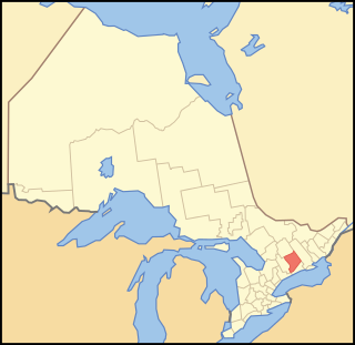
Haliburton is a county of Ontario, Canada, known as a tourist and cottage area in Central Ontario for its scenery and for its resident artists. Minden Hills is the county seat. Haliburton County and the village of Haliburton are named after Thomas Chandler Haliburton, author, statesman, and the first chairman of the Canadian Land and Emigration Company.

<span class="mw-page-title-main">York River (Ontario)</span> River in Ontario, Canada

The York River is a river in Renfrew County, Hastings County and Haliburton County in Ontario, Canada. The river is in the Saint Lawrence River drainage basin, and flows from the southern extension of Algonquin Provincial Park to the Madawaska River.

<span class="mw-page-title-main">Lanark Highlands</span> Township in Ontario, Canada

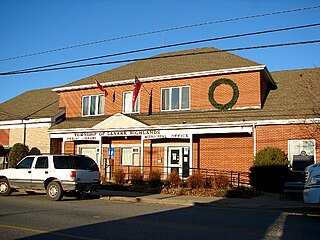
Lanark Highlands is a township in eastern Ontario, Canada in Lanark County. The township administrative offices are located in the village of Lanark.

Peterborough East was a federal electoral district represented in the House of Commons of Canada from 1867 to 1925. It was located in the province of Ontario. It was created by the British North America Act of 1867 which divided the County of Peterborough into two ridings.

Harcourt Park is a nonprofit cottaging corporation established in 1959 by the Sumcot Development Corporation in the municipality of Dysart et al, Haliburton County in Central Ontario, Canada.

<span class="mw-page-title-main">Highlands East, Ontario</span> Township Municipality in Ontario, Canada

Highlands East is a township municipality located in Haliburton County, Ontario, Canada.

The Canadian Land and Emigration Company was an English company formed in 1861 to promote the sale of lands in the Province of Canada, most of which would later form the Municipality of Dysart et al in Haliburton County.

Dysart or Dysert may refer to:

<span class="mw-page-title-main">Algonquin Highlands</span> Township in Ontario, Canada

Algonquin Highlands is a township located in Haliburton County, Ontario, Canada. It has a population of 2,351. The northeastern section of the township is included in Algonquin Provincial Park.

The North York River is a river in the municipality of Dysart et al, Haliburton County in Central Ontario, Canada. It is in the southern extension of Algonquin Provincial Park, is in the Saint Lawrence River drainage basin, and is a left tributary of the York River.

<span class="mw-page-title-main">Opeongo Hills</span>

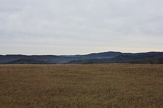
The Opeongo Hills are a range of hills in Southern Ontario, near Algonquin Provincial Park. The hills stretch from Opeongo Lake in Algonquin Park in the west, along the Madawaska and Opeongo Rivers, towards the Opeongo Colonization Road, and extending towards the Deacon Escarpment, Bonnechere, Ontario, and Dacre in the east. To the east of the Opeongo Hills lie the Madawaska River valley, the Mississippi River Valley, and the Ottawa-Bonnechere Graben along the Ottawa River. Its tallest peak is roughly 7 km northeast of Highway 60. At roughly 586 meters, it is the tallest point in Southern Ontario. The community of Foymount is one of the highest settlements in Southern Ontario.

<span class="mw-page-title-main">Gull River (Balsam Lake)</span> River in Haliburton County, Ontario, Canada

The Gull River is a river in Algonquin Highlands and Dysart et al, Haliburton County and the single-tier municipality of Kawartha Lakes in south-central Ontario, Canada. It is in the Trent River and Lake Ontario drainage basins, and flows from southern Algonquin Provincial Park to Balsam Lake on the Trent–Severn Waterway.

Redstone Lake is a lake located in geographic Guilford Township in the Municipality of Dysart et al, Haliburton County in Central Ontario, Canada. It is in the Great Lakes Basin and is part of the Gull River system. At its longest, it is approximately 6.5km.

<span class="mw-page-title-main">Haliburton Sculpture Forest</span> Public sculpture gallery

The Haliburton Sculpture Forest is an outdoor collection of sculptures located in Glebe Park near the village of Haliburton, Ontario, Canada. It is operated by the non-profit organization Haliburton Sculpture Forest et al.

The Redstone River is a river in the municipality of Dysart et al, Haliburton County in central Ontario, Canada that flows from southern Algonquin Provincial Park to the Gull River.

<span class="mw-page-title-main">Koshlong Lake</span>

Koshlong Lake is a lake in the municipalities of Highlands East and Dysart et al, Haliburton County in Central Ontario, Canada. It is part of the Great Lakes Basin.

The Irondale River is a river in Haliburton County in Central Ontario, Canada. It is part of the Great Lakes Basin, and is a left tributary of the Burnt River.

Kennaway Lake is a small lake in the municipality of Dysart et al, Haliburton County in Central Ontario, Canada. It is in the Ottawa River drainage basin.

Fourcorner Lake is a lake in the municipality of Dysart et al, Haliburton County in Central Ontario, Canada. It is partly within Algonquin Provincial Park and is in the Ottawa River drainage basin. The lake takes its name from its location at a quadripoint, the junction point of four geographic townships: Harburn at northwest, Bruton at the northeast, Harcourt at the southeast, and Dudley at the southwest.

References

Footnotes

  1. 1 2 3 "Census Profile, 2016 Census: Dysart et al, Municipality". Statistics Canada . Retrieved June 14, 2019.
  2. "Dysart, Dudley, Harcourt, Guilford, Harburn, Bruton, Havelock, Eyre and Clyde". Geographical Names Data Base . Natural Resources Canada . Retrieved 2011-11-11.
  3. "Toporama (on-line map and search)". Atlas of Canada . Natural Resources Canada. Retrieved 2020-09-01. Shows the area of the municipality highlighted on a map.
  4. 1 2 3 "Ontario Geonames GIS (on-line map and search)". Ontario Ministry of Natural Resources and Forestry. 2014. Retrieved 2020-08-15.
  5. "GeoNames Government of Canada site". Archived from the original on 2009-02-06.
  6. Metadata Consulting, 'A complete list of 5,162 cities, municipalities, districts, towns, townships, villages, hamlets in Canada from Stats Canada's Census in 2016', 2017. Accessed on August 22, 2021.
  7. Natural Resources Canada, 'Lethbridge, Morley's Siding, Brooklyn, Charleston, Jamestown, Portland, Winter Brook and Sweet Bay', 2021. Accessed on August 22, 2021.
  8. 1 2 3 4 5 6 7 8 9 Rayburn, Alan (1997). Place names of Ontario. Toronto: University of Toronto Press. ISBN   0-8020-7207-0 . Retrieved 14 October 2017.
  9. Martinello, C.S. (2015). "The "Statistically Average" Early Haliburton Farm: A Case Study from the Kennaway Settlement" (PDF). Ontario History. 107 (2): 179–197. doi:10.7202/1050634ar. S2CID   186749863 . Retrieved 2021-11-08.
  10. "Kennaway". Geographical Names Data Base . Natural Resources Canada . Retrieved 2011-11-09.
  11. "Founding of Haliburton, The". Online Plaque Guide. Ontario Heritage Trust . Retrieved 2011-11-11.
  12. "Founding of Haliburton". Ontario's Historical Plaques. Retrieved 2011-11-11.
  13. "Victoria Railway, The". Online Plaque Guide. Ontario Heritage Trust . Retrieved 2011-11-11.
  14. "The Victoria Railway". Ontario's Historical Plaques. Retrieved 2011-11-11.
  15. Statistics Canada: 1996, 2001, 2006 census
  16. 1 2 "2011 Community Profiles". 2011 Canadian Census . Statistics Canada. March 21, 2019. Retrieved 2012-02-21.
  17. "Population and dwelling counts: Canada, provinces and territories, census divisions and census subdivisions (municipalities), Ontario". Statistics Canada. February 9, 2022. Retrieved March 31, 2022.
  18. "2021 Community Profiles". 2021 Canadian Census . Statistics Canada. February 4, 2022. Retrieved 2022-04-27.
  19. "2016 Community Profiles". 2016 Canadian Census . Statistics Canada. August 12, 2021. Retrieved 2019-06-14.
  20. "2006 Community Profiles". 2006 Canadian Census . Statistics Canada. August 20, 2019.
  21. "2001 Community Profiles". 2001 Canadian Census . Statistics Canada. July 18, 2021.
  22. McMurtrie, Jeffrey (2008). "Algonquin Provincial Park and the Haliburton Highlands". Wikimedia Commons. Archived from the original on 2011-06-29. Retrieved 2010-07-28.
  23. Paul Vorvis (1 April 2022). "Local History Writer Nila Reynolds plus Brief History of Slavery in Canada Pt 2". Time Warp (Podcast). Canoe FM.

Sources