
The Basin and Range Province is a vast physiographic region covering much of the inland Western United States and northwestern Mexico. It is defined by unique basin and range topography, characterized by abrupt changes in elevation, alternating between narrow faulted mountain chains and flat arid valleys or basins. The physiography of the province is the result of tectonic extension that began around 17 million years ago in the early Miocene epoch.
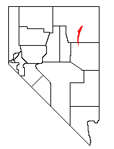
The Ruby Mountains are a mountain range, primarily located within Elko County with a small extension into White Pine County, in Nevada, United States. Most of the range is included within the Humboldt-Toiyabe National Forest. The range reaches a maximum elevation of 11,387 feet (3,471 m) on the summit of Ruby Dome. To the north is Secret Pass and the East Humboldt Range, and from there the Rubies run south-southwest for about 80 miles (130 km). To the east lies Ruby Valley, and to the west lie Huntington and Lamoille Valleys. The Ruby Mountains are the only range of an introduced bird, the Himalayan snowcock, in North America.

The Moine Thrust Belt or Moine Thrust Zone is a linear tectonic feature in the Scottish Highlands which runs from Loch Eriboll on the north coast 190 kilometres (120 mi) south-west to the Sleat peninsula on the Isle of Skye. The thrust belt consists of a series of thrust faults that branch off the Moine Thrust itself. Topographically, the belt marks a change from rugged, terraced mountains with steep sides sculptured from weathered igneous, sedimentary and metamorphic rocks in the west to an extensive landscape of rolling hills over a metamorphic rock base to the east. Mountains within the belt display complexly folded and faulted layers and the width of the main part of the zone varies up to 10 kilometres (6.2 mi), although it is significantly wider on Skye.
In geology, a shear zone is a thin zone within the Earth's crust or upper mantle that has been strongly deformed, due to the walls of rock on either side of the zone slipping past each other. In the upper crust, where rock is brittle, the shear zone takes the form of a fracture called a fault. In the lower crust and mantle, the extreme conditions of pressure and temperature make the rock ductile. That is, the rock is capable of slowly deforming without fracture, like hot metal being worked by a blacksmith. Here the shear zone is a wider zone, in which the ductile rock has slowly flowed to accommodate the relative motion of the rock walls on either side.
The Lewis Overthrust is a geologic thrust fault structure of the Rocky Mountains found within the bordering national parks of Glacier in Montana, United States and Waterton Lakes in Alberta, Canada. The structure was created due to the collision of tectonic plates about 59-75 million years ago that drove a several mile thick wedge of Precambrian rock 50 mi (80 km) eastwards, causing it to overlie softer Cretaceous age rock that is 1300 to 1400 million years younger.

Décollement is a gliding plane between two rock masses, also known as a basal detachment fault. Décollements are a deformational structure, resulting in independent styles of deformation in the rocks above and below the fault. They are associated with both compressional settings and extensional settings.
Extensional tectonics is concerned with the structures formed by, and the tectonic processes associated with, the stretching of a planetary body's crust or lithosphere.

A detachment fault is a gently dipping normal fault associated with large-scale extensional tectonics. Detachment faults often have very large displacements and juxtapose unmetamorphosed hanging walls against medium to high-grade metamorphic footwalls that are called metamorphic core complexes. They are thought to have formed as either initially low-angle structures or by the rotation of initially high-angle normal faults modified also by the isostatic effects of tectonic denudation. They may also be called denudation faults. Examples of detachment faulting include:
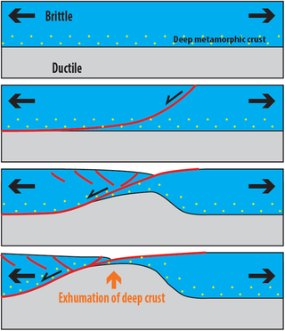
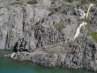
Metamorphic core complexes are exposures of deep crust exhumed in association with largely amagmatic extension. They form, and are exhumed, through relatively fast transport of middle and lower continental crust to the Earth's surface. During this process, high-grade metamorphic rocks are exposed below low-angle detachment faults that show ductile deformation on the lower side (footwall) with amphibolite- to greenschist-facies syndeformational metamorphism, and ductile-brittle to brittle deformation on the upper-side (hanging-wall) with tilted geometries.
The Moine Supergroup is a sequence of Neoproterozoic metamorphic rocks that form the dominant outcrop of the Scottish Highlands between the Moine Thrust Belt to the northwest and the Great Glen Fault to the southeast. The sequence is metasedimentary in nature and was metamorphosed and deformed in a series of tectonic events during the Late Proterozoic and Early Paleozoic. It takes its name from A' Mhòine, a peat bog in northern Sutherland.
The Massif Central is one of the two large basement massifs in France, the other being the Armorican Massif. The Massif Central's geological evolution started in the late Neoproterozoic and continues to this day. It has been shaped mainly by the Caledonian orogeny and the Variscan orogeny. The Alpine orogeny has also left its imprints, probably causing the important Cenozoic volcanism. The Massif Central has a very long geological history, underlined by zircon ages dating back into the Archaean 3 billion years ago. Structurally it consists mainly of stacked metamorphic basement nappes.

The Grouse Creek block is a Precambrian basement province of 2.45 to 2.70 billion year old orthogneisses. The Grouse Creek block is one of several Proterozoic and Archean accreted terranes that lie to the north and west of the Wyoming craton, including the Farmington Canyon Complex, the Selway terrane, the Medicine Hat block and the Priest River complex. Together, these terranes comprise part of the basement rock of the North American continent and have been critical to studies of crustal accretion in the Precambrian. Ongoing study of the Grouse Creek block will contribute to understanding the paleogeography of the Wyoming craton prior to its incorporation into the supercontinent Laurentia approximately 1.86 billion years ago. The name was proposed by David Foster and others.
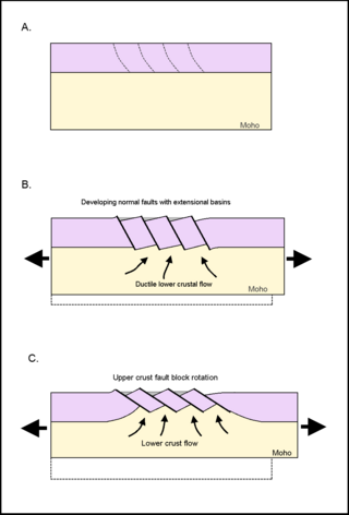
Tilted block faulting, also called rotational block faulting, is a mode of structural evolution in extensional tectonic events, a result of tectonic plates stretching apart. When the upper lithospheric crust experiences extensional pressures, the brittle crust fractures, creating detachment faults. These normal faults express themselves on a regional scale; upper crust fractures into tilted fault blocks, and ductile lower crust ascends. This results in uplift, cooling, and exhumation of ductilely deformed deeper crust. The large unit of tilted blocks and associated crust can form an integral part of metamorphic core complexes, which are found on both continental and oceanic crust.

The Main Central Thrust is a major geological fault where the Indian Plate has pushed under the Eurasian Plate along the Himalaya. The fault slopes down to the north and is exposed on the surface in a NW-SE direction (strike). It is a thrust fault that continues along 2900 km of the Himalaya mountain belt.

The Nordfjord—Sogn Detachment (NSD) is a major extensional shear zone in Norway up to 6 km in thickness, which extends about 120 km along strike from Nordfjord to Sognefjord, bringing Devonian continental coarse clastic sedimentary rocks into close contact with eclogite facies metamorphic rocks of the Western Gneiss Region. It formed towards the end of the Caledonian Orogeny and was mainly active during the Devonian. It has an estimated displacement of at least 70 km and possibly as much as 110 km. It was reactivated during the Mesozoic and may have influenced the development of fault structures in the North Sea rift basin.
In geology, the term exhumation refers to the process by which a parcel of rock, approaches Earth's surface.

The Huangling Anticline or Complex represents a group of rock units that appear in the middle of the Yangtze Block in South China, distributed across Yixingshan, Zigui, Huangling, and Yichang counties. The group of rock involves nonconformity that sedimentary rocks overlie the metamorphic basement. It is a 73-km long, asymmetrical dome-shaped anticline with axial plane orientating in the north-south direction. It has a steeper west flank and a gentler east flank. Basically, there are three tectonic units from the anticline core to the rim, including Archean to Paleoproterozoic metamorphic basement, Neoproterozoic to Jurassic sedimentary rocks, and Cretaceous fluvial deposit sedimentary cover. The northern part of the core is mainly tonalite-trondhjemite-gneiss (TTG) and Cretaceous sedimentary rock called the Archean Kongling Complex. The middle of the core is mainly the Neoproterozoic granitoid. The southern part of the core is the Neoproterozoic potassium granite. Two basins are situated on the western and eastern flanks of the core, respectively, including the Zigui basin and Dangyang basin. Both basins are synforms while Zigui basin has a larger extent of folding. Yuanan Graben and Jingmen Graben are found within the Dangyang Basin area. The Huangling Anticline is an important area that helps unravel the tectonic history of the South China Craton because it has well-exposed layers of rock units from Archean basement rock to Cretaceous sedimentary rock cover due to the erosion of the anticline.
The geology of Nevada began to form in the Proterozoic at the western margin of North America. Terranes accreted to the continent as a marine environment dominated the area through the Paleozoic and Mesozoic periods. Intense volcanism, the horst and graben landscape of the Basin and Range Province originating from the Farallon Plate, and both glaciers and valley lakes have played important roles in the region throughout the past 66 million years.

The geology of Himachal Pradesh is dominated by Precambrian rocks that were assembled and deformed during the India-Asia collision and the subsequent Himalayan orogeny. The Northern Indian State Himachal Pradesh is located in the Western Himalaya. It has a rugged terrain, with elevation ranging from 320m to 6975m. Rock materials in the region are largely from the Indian craton, and their ages range from the Paleoproterozoic to the present day. It is generally agreed that the Indian craton collided with Asia 50-60 million years ago (Ma). Rock sequences were thrust and folded immensely during the collision. The area has also been shaped by focused orographic precipitation, glaciation and rapid erosion.
The Nevadaplano was a high plateau that is proposed to have covered parts of southwestern North America during the late Mesozoic and early Cenozoic, located in the present-day US states of Idaho, Nevada, Utah and possibly others. It most likely formed during the Cretaceous as a consequence of subduction dynamics and may have reached elevations of 3 kilometres (9,800 ft) and more, although its elevation is controversial. It was flanked on the west by the Sierra Nevada, which was traversed by various valleys that came down from the Nevadaplano. Closed basins and numerous volcanic calderas covered the relatively flat Nevadaplano; large volcanic eruptions distributed ignimbrites over the plateau and down the valleys draining it.
