Metcalfe County is a county located in the U.S. state of Kentucky. As of the 2010 census, the population was 10,099. Its county seat is Edmonton. The county was founded in May 1860 and named for Thomas Metcalfe, Governor of Kentucky from 1828 to 1832. It is historically a prohibition or dry county, although as of the uncertified vote of June 28, 2016, the county is no longer dry.

Carroll County is a county located in the northern part of the U.S. state of Kentucky. As of the 2010 census, the population was 10,811. Its county seat is Carrollton. The county was formed in 1838 and named for Charles Carroll of Carrollton, the last living signer of the Declaration of Independence. It is located at the confluence of the Kentucky and Ohio Rivers.

Bullitt County is a county located in the north central portion of the U.S. state of Kentucky. As of the 2010 census, the population was 74,319. The county seat is Shepherdsville. The county was founded in 1796.

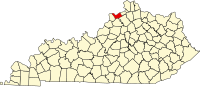
Boone County is a county located in the northern part of the U.S. state of Kentucky. As of the 2010 census, the population was 118,811, making it the fourth-most populous county in Kentucky. Its county seat is Burlington. The county was formed in 1798 from a portion of Campbell County. and was named for frontiersman Daniel Boone.

Shepherdsville is a home rule-class city on the Salt River in Bullitt County, Kentucky, in the United States. It is the seat of its county, located just south of Louisville. The population was 11,222 during the 2010 U.S. Census.

Julian Morton Carroll is an American lawyer and politician from the state of Kentucky. A Democrat, he is a member of the Kentucky Senate, representing Anderson, Franklin, Woodford, Gallatin and Owen counties. From 1974 to 1979, he served as the 54th Governor of Kentucky, succeeding Wendell H. Ford, who resigned to accept a seat in the U.S. Senate. He was the first Kentucky governor from the state's far-western Jackson Purchase region. The lieutenant governor he served with Thelma Stovall was the first woman to be elected Lieutenant Governor of Kentucky.
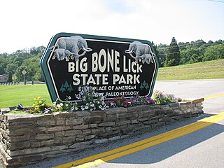
Big Bone Lick State Park is located at Big Bone in Boone County, Kentucky. The name of the park comes from the Pleistocene megafauna fossils found there. Mammoths are believed to have been drawn to this location by a salt lick deposited around the sulfur springs. Other animals including forms of bison, caribou, deer, elk, horse, mastodon, moose, musk ox, peccary, sloth, and possibly tapir also grazed the vegetation and salty earth around the springs that the animals relied on for their diet. The area near the springs was very soft and marshy causing many animals to become stuck with no way to escape. It bills itself as "the birthplace of American paleontology", a term which dates from the 1807 expedition by William Clark undertaken at the direction of President Thomas Jefferson. In Nicholas Cresswell's journal, dated 1774 to 1777, he records a visit in 1775 to what was then called "Elephant Bone Lick." In this account, Cresswell describes finding several bones of "prodigious size", as well as tusk fragments, and teeth—one weighing approximately 10 pounds. While he assumed the bones were from ancient elephants, the local native traditions claimed the bones to be those of white buffaloes that had been poisoned by the salty water.

The Battle of Blue Licks, fought on August 19, 1782, was one of the last battles of the American Revolutionary War. The battle occurred ten months after Lord Cornwallis's surrender at Yorktown, which had effectively ended the war in the east. On a hill next to the Licking River in what is now Robertson County, Kentucky, a force of about 50 Loyalists along with 300 American Indians ambushed and routed 182 Kentucky militiamen. It was the last victory for the Loyalists and Indians during the frontier war. British, Loyalist and Native Indian forces would engage in fighting with American forces once more the following month in Wheeling, West Virginia, during the Siege of Fort Henry.

Big Bone is an unincorporated community in southern Boone County, Kentucky, United States. It is bounded on the west by the Ohio River, and Rabbit Hash, on the south by Big Bone Creek, which empties into the river at Big Bone Landing. The northern extent is along Hathaway Road, and the eastern portion extends not further than U.S. 42, and is approached from that direction by Beaver Road coming from either Richwood or Walton. Big Bone took its name from a nearby prehistoric mineral lick of the same name. Geographical features of interest include Big Bone Lick State Park and the now disappeared Big Bone Island.
The Carroll Lee Cropper Bridge is a continuous steel arch-shaped truss bridge over the Ohio River between Indiana and Kentucky. Built in 1977, the four-lane arched truss span provides a western Ohio River crossing for the Interstate 275 beltway around the Cincinnati area. The section of Interstate 275 on the Cropper bridge is the only Interstate highway in the Cincinnati, Ohio area that goes between Indiana and Kentucky. The bridge is the only highway bridge crossing for 20 miles (32 km) west of the Cincinnati downtown area. The Markland Locks and Dam, which carries Indiana State Road 101 and Kentucky Route 1039, is 40 miles (64 km) south and west of the Cropper Bridge.
Blue Licks Battlefield State Resort Park is a park located near Mount Olivet, Kentucky in Robertson and Nicholas counties. The park encompasses 148 acres (60 ha) and features a monument commemorating the August 19, 1782 Battle of Blue Licks. The battle was regarded as the final battle of the American Revolutionary War.
Knob Lick is an unincorporated community in Estill County, Kentucky, United States. Knob Lick is 9 miles (14 km) west-southwest of Irvine.
Mays Lick(a.k.a.Mayslick, originally known asMay's Lick) is census-designated place and unincorporated community located in Mason County, Kentucky, United States, about nine miles southwest of Maysville.
Mud Lick is a rural unincorporated community in Monroe County, Kentucky, United States. It is concentrated around the intersection of Kentucky Route 63 and Kentucky Route 870, northwest of Tompkinsville.
Lick Creek is an unincorporated community located in Pike County, Kentucky, United States.
Flat Lick is an unincorporated community and census-designated place (CDP) in Knox County, Kentucky, United States. As of the 2010 census, the population was 960.

Paleontology in Kentucky refers to paleontological research occurring within or conducted by people from the U.S. state of Kentucky. Kentucky's abundance of exposed sedimentary rock makes it an ideal source of fossils. The oldest exposed rocks in Kentucky are of Ordovician age. The geologic column of Kentucky also contains rocks deposited during the ensuing periods until the end of the Pennsylvanian. During this span of time the state was first home to a warm shallow sea home to an abundance and variety of brachiopods, cephalopods, crinoids, and trilobites. During the Devonian, a large reef system formed at what is now the Falls of the Ohio. Swamps covered Kentucky during the ensuing Carboniferous period. Then a gap spans from the start of the Permian to the Pleistocene, although the gap is interrupted by minor deposits of Cretaceous and Eocene rocks. These deposits mainly preserve plant fossils. Ice Age Kentucky was home to short-faced bear, bison, elk, lions, mammoths, mastodons, and giant ground sloths. Local Native Americans interpreted fossils of this age at Big Bone Lick as belonging to ancient monsters killed by benevolent mystical little people. This same fossil deposit would attract attention from major American figures like George Washington, Daniel Boone, and, especially, Thomas Jefferson. Amateur fossil collectors should be aware that they need permission from landowners to prospect legally on private property. Brachiopods are the Kentucky state fossil.
Sulphur Lick is a rural unincorporated community in northwestern Monroe County, Kentucky, United States. The community is located around the intersection of Kentucky Route 678 and Kentucky Route 839.