Antoine-Labelle is a regional county municipality located in the Laurentides region of Quebec, Canada. Its seat is Mont-Laurier. It is named for Antoine Labelle.

Baie-Saint-Paul is a city in the Province of Quebec, Canada, on the northern shore of the Saint Lawrence River. Baie-Saint-Paul is the seat of Charlevoix Regional County Municipality. The city is situated at the mouth of the Gouffre River. It is known for its art galleries, shops and restaurants.

Les Chenaux is a regional county municipality in central Quebec, Canada, in the Mauricie region. The seat is in Saint-Luc-de-Vincennes. It is located adjacent on the east of Trois-Rivières on the Saint Lawrence River. It has a land area of 872.04 square kilometres (336.70 sq mi) and a population of 17,865 inhabitants in the Canada 2011 Census. Its largest community is the parish of Notre-Dame-du-Mont-Carmel.
Mauricie is a traditional and current administrative region of Quebec. La Mauricie National Park is contained within the region, making it a prime tourist location. The region has a land area of 35,860.05 km² and a population of 266,112 residents as of the 2016 Census. Its largest cities are Trois-Rivières and Shawinigan.

Château-Richer is a small town situated in the Capitale-Nationale region of Quebec, Canada. Located on the north shore of the Saint Lawrence River east of Quebec City, Château-Richer is the seat for the Côte-de-Beaupré Regional County Municipality.

Sainte-Anne-des-Monts is a city in the Gaspésie–Îles-de-la-Madeleine region of the province of Quebec in Canada.

Saint-Roch-de-l'Achigan is a Quebec municipality located in the Montcalm Regional County Municipality located in the Lanaudière region. It is on the banks of the Achigan River, a tributary of the L'Assomption River. According to the town's website, the population is approximately 5,100 and growing steadily as a result of the suburban sprawl in the North Shore of Greater Montreal.

Beaupré is a ville in the Canadian province of Quebec, located in La Côte-de-Beaupré Regional County Municipality. The town is along the Saint Lawrence River and Route 138 at the mouth of the Sainte-Anne-du-Nord River.
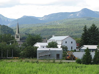
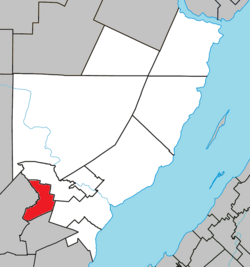
Saint-Urbain is a parish municipality located in the Charlevoix Regional County Municipality, in Capitale-Nationale region, in Quebec, Canada.

Notre-Dame-des-Sept-Douleurs is an island municipality in the Bas-Saint-Laurent region of Quebec, Canada, part of the Rivière-du-Loup Regional County Municipality. It is located on and contiguous with Île Verte in the Saint Lawrence River, about 20 kilometres (12 mi) north-east of Rivière-du-Loup. The name Île Verte was given in 1621 by Samuel de Champlain written "Isle Verte".

La Macaza is a municipality and village in the province of Quebec, Canada. The village is located in the Laurentian Mountains, in the Laurentian region, in Antoine-Labelle Regional County Municipality. Its population was 1150 in the 2016 Canadian census.

Portneuf is a municipality in the Portneuf Regional County Municipality, in the province of Quebec, Canada. It is located on the Saint Lawrence River, between Quebec City and Trois-Rivières. The Portneuf River runs on the east side of the town centre.
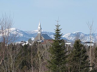
Saint-Hilarion is a parish municipality in Charlevoix Regional County Municipality, in the administrative region of Capitale-Nationale of the province of Quebec, in Canada.

Notre-Dame-de-la-Merci is a municipality in the Lanaudière region of Quebec, Canada, part of the Matawinie Regional County Municipality.

La Doré is a parish municipality in Quebec, Canada, in the regional county municipality of Le Domaine-du-Roy and the administrative region of Saguenay–Lac-Saint-Jean.

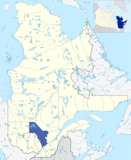
Lac-Pikauba is an unorganized territory in the Capitale-Nationale region of Quebec, Canada. It is a large, unpopulated, undeveloped territory that makes up two-thirds of the Charlevoix Regional County Municipality.

The rivière du Gouffre is a tributary of the left bank of the Saint-Laurent river, flowing into the Capitale-Nationale administrative region, Quebec (Canada). This watercourse flows through Regional County Municipality from:
The Rivière du Gouffre Sud-Ouest is a tributary of the eastern bank of the intermediate part of the Rivière du Gouffre, flowing in the unorganized territory of Lac-Pikauba and the municipality of Saint-Urbain, in the Charlevoix Regional County Municipality, in the administrative region of the Capitale-Nationale, in the province of Quebec, in Canada.
The Chicago River is a tributary of the east bank of the middle part of the Rivière du Gouffre, flowing in the administrative region of Capitale-Nationale, in the province from Quebec, to Canada. The course of this river flows through the regional county municipalities (MRCs) of:
The Rivière à la Loutre is a tributary of the eastern bank of the intermediate part of the Rivière du Gouffre, flowing in the administrative region of Capitale-Nationale, in the province from Quebec, to Canada. The course of this river flows through the regional county municipalities (MRCs) of: