Mednoye is a village in Kalininsky District of Tver Oblast, Russia, located on the Tvertsa River, 28 km west of Tver, by the Moscow–St.Petersburg highway. Population: 3,047 (1992).

Torzhok is a town in Tver Oblast, Russia, located on the Tvertsa River along the federal highway M10 and a branch of the Oktyabrskaya Railway division of the Russian Railways. The town is famous for its folk craft of goldwork embroidery. Population: 47,644 (2010 Census); 48,967 (2002 Census); 49,982 (1989 Census).

The Tvertsa is a river in Vyshnevolotsky, Spirovsky, Torzhoksky, and Kalininsky Districts, as well as in the cities of Torzhok and Tver in Tver Oblast, Russia, a left tributary of the Volga. It is 188 kilometres (117 mi) long, and the area of its basin 6,510 square kilometres (2,510 sq mi). The principal tributaries of the Tvertsa are the Malaya Tigma (left), the Shchegrinka (right), the Osuga (right), the Logovyazh (left), and the Kava (left).

Kuvshinovo is a town and the administrative center of Kuvshinovsky District in Tver Oblast, Russia, located on the Osuga, 133 kilometers (83 mi) from Tver, the administrative center of the oblast. Population: 10,007 (2010 Census); 11,276 (2002 Census); 12,435 (1989 Census).
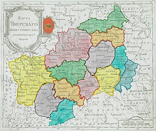
Administratively, Tver Oblast is divided into two urban-type settlements under the federal government management, five cities and towns of oblast significance, and thirty-six districts.

Likhoslavl is a town and the administrative center of Likhoslavlsky District in Tver Oblast, Russia, located on the Moscow–St. Petersburg Railway, 41 kilometers (25 mi) northwest of Tver, the administrative center of the oblast. Population: 12,257 (2010 Census); 12,515 (2002 Census); 13,449 (1989 Census).


Firovsky District is an administrative and municipal district (raion), one of the thirty-six in Tver Oblast, Russia. It is located in the north of the oblast and borders with the urban-type settlement of Ozyorny in the north, Bologovsky District in the northeast, Vyshnevolotsky District in the east, Kuvshinovsky District in the south, Ostashkovsky District in the southwest, Demyansky District of Novgorod Oblast in the west, and with Valdaysky District, also of Novgorod Oblast, in the northwest. The area of the district is 1,836 square kilometers (709 sq mi). Its administrative center is the urban locality of Firovo. Population: 9,396 ; 11,919 (2002 Census); 14,282 (1989 Census). The population of Firovo accounts for 25.9% of the district's total population.

Kuvshinovsky District is an administrative and municipal district (raion), one of the thirty-six in Tver Oblast, Russia. It is located in the center of the oblast and borders with Vyshnevolotsky District in the north, Torzhoksky District in the east, Staritsky District in the south, Selizharovsky District in the southwest, Ostashkovsky District in the west, and with Firovsky District in the northwest. The area of the district is 1,874 square kilometers (724 sq mi). Its administrative center is the town of Kuvshinovo. Population: 15,386 ; 17,847 (2002 Census); 20,601 (1989 Census). The population of Kuvshinovo accounts for 65.0% of the district's total population.

Likhoslavlsky District is an administrative and municipal district (raion), one of the thirty-six in Tver Oblast, Russia. It is located in the center of the oblast and borders with Maksatikhinsky District in the north, Rameshkovsky District in the east, Kalininsky District in the south, Torzhoksky District in the southwest, and with Spirovsky District in the northwest. The area of the district is 1,781 square kilometers (688 sq mi). Its administrative center is the town of Likhoslavl. Population: 28,492 ; 30,079 (2002 Census); 33,942 (1989 Census). The population of Likhoslavl accounts for 43.0% of the district's total population.
Oleninsky District is an administrative and municipal district (raion), one of the thirty-six in Tver Oblast, Russia. It is located in the southwest of the oblast and borders with Selizharovsky District in the north, Rzhevsky District in the east, Sychyovsky District of Smolensk Oblast in the southeast, Belsky District in the south, and with Nelidovsky District in the west. The area of the district is 2,675 square kilometers (1,033 sq mi). Its administrative center is the urban locality of Olenino. Population: 12,675 ; 14,817 (2002 Census); 18,892 (1989 Census). The population of Olenino accounts for 38.8% of the district's total population.

Penovsky District is an administrative and municipal district (raion), one of the thirty-six in Tver Oblast, Russia. It is located in the northwest of the oblast and borders with Ostashkovsky District in the north, Selizharovsky District in the east, Andreapolsky District in the south, and with Maryovsky District of Novgorod Oblast in the west. The area of the district is 2,385 square kilometers (921 sq mi). Its administrative center is the urban locality of Peno. Population: 6,864 ; 8,523 (2002 Census); 10,291 (1989 Census). The population of Peno accounts for 61.5% of the district's total population.
Rzhevsky District is an administrative and municipal district (raion), one of the thirty-six in Tver Oblast, Russia. It is located in the south of the oblast and borders with Staritsky District in the north, Zubtsovsky District in the east, Sychyovsky District of Smolensk Oblast in the south, Oleninsky District in the west, and with Selizharovsky District in the northwest. The area of the district is 2,760 square kilometers (1,070 sq mi). Its administrative center is the town of Rzhev. Population: 12,480 ; 14,674 (2002 Census); 17,664 (1989 Census).

Spirovsky District is an administrative and municipal district (raion), one of the thirty-six in Tver Oblast, Russia. It is located in the center of the oblast and borders with Maksatikhinsky District in the north, Likhoslavlsky District in the east, Torzhoksky District in the south, and with Vyshnevolotsky District in the west. The area of the district is 1,498 square kilometers (578 sq mi). Its administrative center is the urban locality of Spirovo. Population: 12,203 ; 13,805 (2002 Census); 15,412 (1989 Census). The population of Spirovo accounts for 51.4% of the district's total population.

Staritsky District is an administrative and municipal district (raion), one of the thirty-six in Tver Oblast, Russia. It is located in the central and southern parts of the oblast and borders with Kuvshinovsky District in the north, Torzhoksky District in the northeast, Kalininsky District in the east, Lotoshinsky District of Moscow Oblast in the southeast, Zubtsovsky District in the south, Rzhevsky District in the southwest, and with Selizharovsky District in the west. The area of the district is 3,005 square kilometers (1,160 sq mi). Its administrative center is the town of Staritsa. Population: 24,056 ; 25,765 (2002 Census); 28,764 (1989 Census). The population of Staritsa accounts for 35.8% of the district's total population.

Torzhoksky District is an administrative and municipal district (raion), one of the thirty-six in Tver Oblast, Russia. It is located in the center of the oblast and borders with Spirovsky District in the north, Likhoslavlsky District in the northeast, Kalininsky District in the east, Staritsky District in the south, Kuvshinovsky District in the west, and with Vyshnevolotsky District in the northwest. The area of the district is 3,128 square kilometers (1,208 sq mi). Its administrative center is the town of Torzhok. Population: 22,534 ; 23,856 (2002 Census); 27,376 (1989 Census).

Vyshnevolotsky District is an administrative and municipal district (raion), one of the thirty-six in Tver Oblast, Russia. It is located in the north of the oblast and borders with Udomelsky District in the north, Maksatikhinsky District in the northeast, Spirovsky District in the east, Torzhoksky District in the south, Kuvshinovsky District in the southwest, Firovsky District in the west, and with Bologovsky District in the northwest. The area of the district is 3,400 square kilometers (1,300 sq mi). Its administrative center is the town of Vyshny Volochyok. Population: 25,421 ; 28,918 (2002 Census); 34,579 (1989 Census).