Nyenga, Uganda

Last updated

Nyenga
Uganda location map.svg
Red pog.svg
Nyenga
Location in Uganda
Coordinates: 00°22′48″N33°09′00″E / 0.38000°N 33.15000°E / 0.38000; 33.15000 Coordinates: 00°22′48″N33°09′00″E / 0.38000°N 33.15000°E / 0.38000; 33.15000
Country Flag of Uganda.svg Uganda
Region Central Uganda
District Buikwe District
Municipality Njeru Municipality
Elevation
4,042 ft (1,232 m)
Population
 (2020 Estimate)
  Total55,600

Nyenga is an urban division of one of the municipalities in Buikwe District, in the Central Region of Uganda. Nyenga Division is one of the three divisions of the city of Njeru. The other two divisions are Wakisi Division and Njeru Division. [1]

Contents

Location

Nyenga is located in Njeru Municipality, approximately 7 kilometres (4 mi), by road, south of Njeru Division, the central business district of the municipality. [2] The coordinates of Nyenga, Uganda are:0°22'48.0"N; 33°09'00.0"E (Latitude:0.3800; Longitude:33.1500). [3] Nyenga is situated at an average altitude of 1,232 metres (4,042 ft), above mean sea level. [4]

Population

In 2015, Uganda Bureau of Statistics (UBOS) estimated the population of Nyenga Division at 50,400. In 2020, the population agency estimated the mid-year population of Nyenga at 55,600 inhabitants. Of these, 28,200 (50.7 percent) were females and 27,400 (49.3 percent) were males. UBOS calculated that the population of Nyenga increased at an average rate of 2.0 percent annually, between 2015 and 2020. [5]

Historical population
YearPop.±%
201550,400    
202055,600+10.3%
source: [5]

Points of interest

The following points of interest lie within or near Nyenga: (a) Nyenga Roman Catholic Church [6] (b) Nyenga Mission Hospital, also St. Francis Hospital Nyenga, is a 75-bed community hospital that was founded in 1932 as a leprosarium. Owned by the Roman Catholic Diocese of Lugazi. [7] (c) Saint Joseph Minor Seminary Nyenga [8] (d) Saint Francis School of Nursing and Midwifery [9] and (e) Nyenga Children’s Home In Uganda, an extended family for destitute children. [10] [11]

The Mukono–Kyetume–Katosi–Nyenga Road passes through Nyenga in a general southwest to northeast direction on the way to the Source of the Nile Bridge. [12]

See also

Related Research Articles

Mukono District District in Uganda

Mukono is one of the districts in the Central Region of Uganda. The town of Mukono home to the district's main commercial center and district headquarters.

Mbale Place in Eastern Uganda, Uganda

Mbale is a city in the Eastern Region of Uganda. It is the main municipal, administrative, and commercial center of Mbale District and the surrounding sub-region.

Masindi Place in Western Region of Uganda, Uganda

Masindi is a town in the Western Region of Uganda. It is on the road between Kampala and the Murchison Falls National Park. It is the site of the headquarters of the Masindi District.

Mbarara Place in Western Region, Uganda

Mbarara City is a city in the Western Region of Uganda and the second largest city in Uganda after Kampala. The city is divided into 6 boroughs/divisions of Kakoba Division, Kamukuzi Division, Nyamitanga Division, Biharwe Division, Kakiika Division, Nyakayojo Division. It is the main commercial centre of most of south western districts of Uganda and the site of the district headquarters. In May 2019, the Uganda's cabinet granted Mbarara a city status, which started on 1 July 2020.

Mpigi Place in Central Uganda, Uganda

Mpigi is a town in Mawokota County, Mpigi District, in Central Uganda. Mpigi is the municipal, administrative and commercial headquarters of Mpigi District. The district is named after the town.

Moyo Town Town in Uganda

Moyo, is the main municipal, administrative, and commercial center of Moyo District in the Northern Region of Uganda. The district headquarters are located here.

Kisoga, Mukono Place in Central Region of Uganda, Uganda

Kisoga is a town in Mukono District in Central Uganda.

Mukono Town Urban centre in Uganda

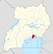
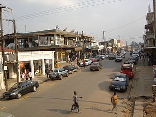
Mukono Town is a municipality in Mukono District in the Central Region of Uganda. The town is administered by the Mukono Town Council. The district headquarters are located in this town.

Njeru Place in Uganda

Njeru is a town in Buikwe District, in the Central Region of Uganda. It is the largest town in the district. It is mainly a residential town. However, it hosts industries such as East African Packaging Solutions Limited, a manufacturer of paper packaging supplies, Nile Breweries Limited, a subsidiary of AB InBev and Nyanza Textile Industries Limited (Nytil), a textile manufacturer.

Mityana Place in Central Uganda, Uganda

Mityana, is a town in the Central Region of Uganda. It is the main municipal, administrative, and commercial center of Mityana District, and the district headquarters are located there.

Lugazi Place in Central Region of Uganda, Uganda

Lugazi is a town in the Buikwe District of the Central Region of Uganda. The town is also called "Kawolo", and the two names are interchangeably used by the local inhabitants.

The Kampala–Jinja Highway is a road in Uganda, connecting the cities of Kampala and Jinja. Sometimes referred to as Kampala–Jinja Road, it is a busy road, with several towns, trading centers and other points of interest along the way. As of October 2016, a new, wider, four-lane dual carriageway expressway, the Kampala–Jinja Expressway, is proposed to be constructed south of the present highway to relieve traffic and complement existing transport infrastructure between Kampala and Jinja.

Buikwe Town in Central Region, Uganda

Buikwe, sometimes spelled Buyikwe, is a town in Buikwe District, Uganda. It is the administrative center of the district and the location of the district headquarters.

Lyantonde Place in Central Region of Uganda

Lyantonde is a town in the southern part of the Central Region of Uganda. It is the main municipal, administrative, and commercial center of Lyantonde District.

Nkokonjeru Place in Central Region of Uganda, Uganda

Nkokonjeru is a town council in Buikwe District in the Central Region of Uganda with villages such as: Namaliiri, Kigulu, Mulajje, Naziwanga, Ndolwa, Buira, Bukasa, Wabiduuku, Nsuube and Nkokonjeru Central. The town's name means "White Chicken" in English.

Ngogwe Place in Uganda

Ngogwe is a municipality in Buikwe District in the Central Region of Uganda.

St. Francis Hospital Nkokonjeru Private non-profit community hospital in Uganda

St. Francis Hospital Nkokonjeru, commonly referred to as Nkokonjeru Hospital, is a private, non-profit, community hospital in Uganda. It is owned by the Roman Catholic Diocese of Lugazi.

The Mukono–Kyetume–Katosi–Nyenga Road is a road in the Central Region of Uganda, connecting the towns of Mukono, Kyetume and Katosi in Mukono District to Nkokonjeru and Nyenga in Buikwe District.

Kyetume Place in Central Region of Uganda, Uganda

Kyetume is a township in Mukono District in the Central Region of Uganda.

Nyenga Mission Hospital Private faith-based, non-profit, community hospital in Uganda

Nyenga Mission Hospital, whose formal name is St. Francis Hospital Nyenga, but is commonly referred to as Nyenga Hospital, is a non-profit, community hospital in Uganda. It is owned and operated by the Roman Catholic Diocese of Lugazi.

References

  1. Maurice Muhwezi (19 October 2020). "Musoke Dumps NRM over Electoral Fraud, Nominated Independent". Red Pepper . Mukono, Uganda. Retrieved 26 July 2021.
  2. Google (26 July 2021). "Road Distance Between Downtown Njeru And Nyenga Mission Hospital With Interactive Map" (Map). Google Maps . Google. Retrieved 26 July 2021.
  3. "Location of Nyenga, Njeru Municipality, Central Region, Uganda" . Retrieved 26 July 2021.
  4. Floodmap (26 July 2021). "Elevation of Nyenga, Njeru Municipality, Uganda". Floodmap.net. Retrieved 26 July 2021.
  5. 1 2 Uganda Bureau of Statistics (14 June 2020). "The population development of Nyenga as well as related information and services". Citypopulation.de Quoting Uganda Bureau of Statistics . Retrieved 26 July 2021.
  6. Google (26 July 2021). "Location of Nyenga Roman Catholic Church, Nyenga, Uganda" (Map). Google Maps . Google. Retrieved 26 July 2021.
  7. Kathleen Vongsathorn (1 August 2012). ""First and foremost the evangelist"? Mission and government priorities for the treatment of leprosy in Uganda, 1927-1948". Journal of Eastern African Studies. 6: 544–560. doi:10.1080/17531055.2012.696906. PMC   4060234 . PMID   24949084.
  8. Google (26 July 2021). "Location of Saint Joseph Minor Seminary Nyenga In Uganda" (Map). Google Maps . Google. Retrieved 26 July 2021.
  9. Google (26 July 2021). "Location of Nyenga St. Francis School of Nursing and Midwifery" (Map). Google Maps . Google. Retrieved 26 July 2021.
  10. Nyenga Foundation (July 2021). "About the Foundation". Nyenga Foundation. Retrieved 26 July 2021.
  11. Global Hand (2021). "Nyenga Foundation (Nyenga Children's Home)". Globalhand.org. Hong Kong. Retrieved 26 July 2021.
  12. Google (26 July 2021). "Map Showing The Mukono–Kyetume–Katosi–Nyenga Road Going Through Nyenga With Extension To The New Nile Bridge" (Map). Google Maps . Google. Retrieved 26 July 2021.