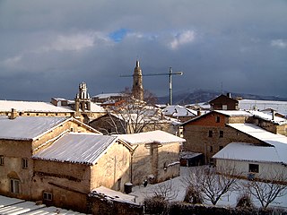
Orendain is a town located in the province of Gipuzkoa, in the autonomous community of Basque Country, northern Spain.

Alegría-Dulantzi is a town and municipality located in the province of Álava, in the Basque Country, northern Spain.

Arundel House was a London town-house or palace located between the Strand and the River Thames, near St Clement Danes. It was originally the town house of the Bishops of Bath and Wells, during the Middle Ages. In 1539 it was given to William Fitzwilliam, Earl of Southampton.

WADS is a radio station broadcasting a Spanish Religious format. Licensed to Ansonia, Connecticut, United States, it serves the Bridgeport area. The station is currently owned by Radio Amor.

Benwood is an unincorporated community in Van Buren Township, Clay County, Indiana, United States. It is part of the Terre Haute Metropolitan Statistical Area.

Jaworowo is a village in the administrative district of Gmina Strzelno, within Mogilno County, Kuyavian-Pomeranian Voivodeship, in north-central Poland. It lies approximately 8 kilometres (5 mi) south-west of Strzelno, 15 km (9 mi) south-east of Mogilno, 61 km (38 mi) south of Bydgoszcz, and 62 km (39 mi) south-west of Toruń.

Qanlıkənd is a village in the Kalbajar Rayon of Azerbaijan.

Cicimli is a village in the Lachin Rayon of Azerbaijan.

İkinci Yaşma is a village in the Khizi Rayon of Azerbaijan.

Lasowice is a village in the administrative district of Gmina Otmuchów, within Nysa County, Opole Voivodeship, in south-western Poland, close to the Czech border. It lies approximately 8 kilometres (5 mi) north-west of Otmuchów, 17 km (11 mi) west of Nysa, and 62 km (39 mi) west of the regional capital Opole.
Stone is a populated place in Humboldt County, California. It is located across the Eel River from Belleview, along the right of way of the Northwestern Pacific Railroad, 6.5 miles (10.5 km) south-southeast of Fortuna, at an elevation of 92 feet (28 m).

Commune II (Niamey), also known as Niamey II, is an urban commune in Niger. It is a commune of the capital city of Niamey.

Commune IV (Niamey), also known as Niamey IV, is an urban commune in Niger. It is a commune of the capital city of Niamey.

Bogunovac is a village in the municipality of Medveđa, Serbia. According to the 2002 census, the village has a population of 89 people.

Slateford is an unincorporated community in Northampton County, Pennsylvania, United States. The nearest communities are Stroudsburg to the north and Portland to the south. Slateford is about 1 mile (1.4 km) from the Delaware Water Gap. Its name comes from its location at the edge of the Northampton Slate Belt. Immigrants from Wales and England came in the 19th century to work in the slate quarries. Slateford is the location of Slateford Junction, the connection between the Lackawanna Railroad's old mainline and the Lackawanna Cut-Off.

Brakovci is a village in the municipality of Srebrenica, Bosnia and Herzegovina.
Oued Lilli is a town and commune in Tiaret Province in northwestern Algeria.
Peoria is a census-designated place (CDP) in Arapahoe County, Colorado, United States. The population as of the 2010 Census was 163.
Woodlyn is an unincorporated community in Pickaway County, in the U.S. state of Ohio.
Nemah is an unincorporated community in Pacific County, in the U.S. state of Washington.


