
Nassau Village-Ratliff is a census-designated place (CDP) in Nassau County, Florida, United States. The population was 5,337 at the 2010 census.

Cestica is a village and municipality in Croatia in the Varaždin County. According to the 2001 census, there are 5,678 inhabitants, the majority of whom are Croats.

The Kadéï River is a tributary of the Sangha River that flows through Cameroon and the Central African Republic. Its total drainage basin is 24,000 km². The river rises from the eastern Adamawa Plateau, southeast of Garoua-Boulaï (5°53′50″N14°33′30″E in Cameroon's East Province. The Kadéï is swelled by two tributaries, the Doumé at Mindourou and the Boumbé, before flowing east into the Central African Republic. At Nola, the Kadéï meets the Mambéré and becomes the Sangha. The Kadéï is part of the Congo River basin.
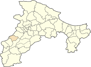
Yesönzüil is a sum (district) of Övörkhangai Province in southern Mongolia.
The Church of the Annunciation is located at 3547 Clifton Avenue at Resor Street in Cincinnati, Ohio, United States. The Church is located in the Clifton neighborhood. It is part of the Clifton Avenue Historic District. This historic parish was founded, in February 1910, the present church was completed in August 1930. This church was designed by Boston architect Edward T. P. Graham, who was active in both the Archdiocese of Boston and the Archdiocese of Cincinnati in the first half of the 20th century.

Craig is an unincorporated community in Washington Township, Decatur County, Indiana.
Chelata is a town in northern Algeria.

Baghramyan, Bagramyan or Baghramian; formerly known as Bashnalu, is a village in the Ararat Province of Armenia. It is named after the Soviet Armenian military commander and Marshal of the Soviet Union Hovhannes Baghramyan.
Ogrodniki is a village in the administrative district of Gmina Narew, within Hajnówka County, Podlaskie Voivodeship, in north-eastern Poland.

Ożary Wielkie is a village in the administrative district of Gmina Rutki, within Zambrów County, Podlaskie Voivodeship, in north-eastern Poland. It lies approximately 23 kilometres (14 mi) north-east of Zambrów and 46 km (29 mi) west of the regional capital Białystok.

Alchaly is a village in the Kalbajar Rayon of Azerbaijan.
Manasterzec is a village in the administrative district of Gmina Lesko, within Lesko County, Subcarpathian Voivodeship, in south-eastern Poland. It lies approximately 6 kilometres (4 mi) north of Lesko and 63 km (39 mi) south-east of the regional capital Rzeszów.
Ludwikówko is a settlement in the administrative district of Gmina Luzino, within Wejherowo County, Pomeranian Voivodeship, in northern Poland. It lies approximately 5 kilometres (3 mi) south of Luzino, 13 km (8 mi) south-west of Wejherowo, and 39 km (24 mi) north-west of the regional capital Gdańsk.

Al-Salihiyah is a municipality and a neighborhood of Damascus, Syria. It lies to the northwest of the old walled city of Damascus and about 2.4 kilometres (1.5 mi) southeast the Citadel at the foot of Mount Qasioun. The quarter is famous for its cemetery of holy men. It houses the Syrian Parliament building. It also has the Hanabila Mosque.

Nghiên Loan is a rural commune (xã) of Pác Nặm District, Bắc Kạn Province, in Vietnam.

Linnaka is a village in Saaremaa Parish, Saare County in western Estonia.
Smeetsland is a neighborhood of Rotterdam, Netherlands.
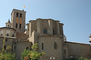
The Cathedral of Solsona is a cathedral in Solsona, Catalonia. The apse, in Roman style, probably dates from the twelfth century.

Bezdonys Manor is a former residential manor near Bezdonys, Vilnius district in Lithuania.
Greenwood is an unincorporated community in Franklin County, in the U.S. state of Pennsylvania.


