Sumiainen is a former municipality of Finland.
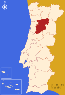
The District of Viseu is located in the Central Inland of Portugal, the District Capital is the city of Viseu. It is the only district of Portugal which does not border Spain or the sea.

Randolph Corner is an unincorporated community on Willisville Road in southwestern Loudoun County, Virginia. Randolph Corner is located at 39°1′44″N77°49′43″W.

Maçkalaşen is a village in the Martuni Province of the de facto Republic of Artsakh, de jure part of the Republic of Azerbaijan.
Sobu is a village in the Zangilan Rayon of Azerbaijan.

Korytnica is a village in the administrative district of Gmina Sobków, within Jędrzejów County, Świętokrzyskie Voivodeship, in south-central Poland. It lies approximately 7 kilometres (4 mi) south-east of Sobków, 16 km (10 mi) east of Jędrzejów, and 27 km (17 mi) south of the regional capital Kielce.
Wlonice is a village in the administrative district of Gmina Wojciechowice, within Opatów County, Świętokrzyskie Voivodeship, in south-central Poland. It lies approximately 6 kilometres (4 mi) east of Wojciechowice, 17 km (11 mi) east of Opatów, and 74 km (46 mi) east of the regional capital Kielce.

Site 200 at the Baikonur Cosmodrome is a launch site used by Proton rockets. It consists of two launch pads, areas 39 and 40. Area 39 is currently used for Proton-M launches, including commercial flights conducted by International Launch Services. Area 40 is currently inactive, as it was slated to be rebuilt as a launch site for the Angara rocket. Although the project was relocated to Site 250, Area 40 was not put back into service.
Samborzec is a village in Sandomierz County, Świętokrzyskie Voivodeship, in south-central Poland. It is the seat of the gmina called Gmina Samborzec. It lies approximately 8 kilometres (5 mi) south-west of Sandomierz and 78 km (48 mi) east of the regional capital Kielce.
Piotrówek is a village in the administrative district of Gmina Trojanów, within Garwolin County, Masovian Voivodeship, in east-central Poland.
Koziegłowy is a village in the administrative district of Gmina Pokrzywnica, within Pułtusk County, Masovian Voivodeship, in east-central Poland.
Poraj is a settlement in the administrative district of Gmina Wicko, within Lębork County, Pomeranian Voivodeship, in northern Poland. It lies approximately 3 kilometres (2 mi) south-west of Wicko, 16 km (10 mi) north-west of Lębork, and 75 km (47 mi) north-west of the regional capital Gdańsk.
Brzeziny is a village in the administrative district of Gmina Pasłęk, within Elbląg County, Warmian-Masurian Voivodeship, in northern Poland. It lies approximately 3 kilometres (2 mi) south-west of Pasłęk, 18 km (11 mi) south-east of Elbląg, and 63 km (39 mi) north-west of the regional capital Olsztyn.
Nowy Ramuk is a settlement in the administrative district of Gmina Purda, within Olsztyn County, Warmian-Masurian Voivodeship, in northern Poland. It lies approximately 11 kilometres (7 mi) south-west of Purda and 15 km (9 mi) south of the regional capital Olsztyn.

Cedar Grove is an unincorporated community in El Dorado County, California. It lies at an elevation of 3386 feet.

Huishui is a county of south-central Guizhou province, China. It is under the administration of the Qiannan Buyei and Miao Autonomous Prefecture.
Berrytown is an unincorporated community in Rockingham County, Virginia, United States. Its elevation is 1,010 ft (308 m), and it is located at 38°22′06″N78°39′25″W.
Schwartenberg is a mountain of Saxony, southeastern Germany.

Maoča is a village in the municipality of Brčko, Bosnia and Herzegovina.
Corn Island is a forested island of Essex County, Massachusetts.


