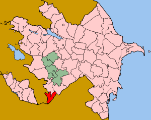
Zangilan Rayon is a de jure administrative territorial entity in the south-western part of the Republic of Azerbaijan, but de facto this territory was occupied by Armenian forces in autumn of 1993, during the Nagorno-Karabakh War. Since then, it has been governed by the unrecognized Republic of Artsakh as part of its Qashatagh Province. Zangilan district was occupied by Armenian military forces on October 29, 1993.

Randolph Corner is an unincorporated community on Willisville Road in southwestern Loudoun County, Virginia. Randolph Corner is located at 39°1′44″N77°49′43″W.

The Franciscan Church is a place of worship in Cluj-Napoca, Romania. It was built between 1260 and 1290, on the site of an older Catholic church destroyed during the Tatar invasions in 1241.

Ağanus is a village in the Lachin Rayon of Azerbaijan.

Maçkalaşen is a village in the Martuni Province of the de facto Republic of Artsakh, de jure part of the Republic of Azerbaijan.

Qaradərə is a village in the Zangilan Rayon of Azerbaijan.
Zadąbrów-Wiatraki is a village in the administrative district of Gmina Warta, within Sieradz County, Łódź Voivodeship, in central Poland.

Boleścice is a village in the administrative district of Gmina Sędziszów, within Jędrzejów County, Świętokrzyskie Voivodeship, in south-central Poland. It lies approximately 4 kilometres (2 mi) east of Sędziszów, 15 km (9 mi) west of Jędrzejów, and 49 km (30 mi) south-west of the regional capital Kielce.

Site 200 at the Baikonur Cosmodrome is a launch site used by Proton rockets. It consists of two launch pads, areas 39 and 40. Area 39 is currently used for Proton-M launches, including commercial flights conducted by International Launch Services. Area 40 is currently inactive, as it was slated to be rebuilt as a launch site for the Angara rocket. Although the project was relocated to Site 250, Area 40 was not put back into service.

Makuhari Station is a railway station on the Sōbu Main Line in Makuharicho, Hanamigawa Ward, Chiba City, Chiba Prefecture, Japan, operated by East Japan Railway Company.

Brzeziny is a village in the administrative district of Gmina Pasłęk, within Elbląg County, Warmian-Masurian Voivodeship, in northern Poland. It lies approximately 3 kilometres (2 mi) south-west of Pasłęk, 18 km (11 mi) south-east of Elbląg, and 63 km (39 mi) north-west of the regional capital Olsztyn.

Szczecinki is a village in the administrative district of Gmina Olecko, within Olecko County, Warmian-Masurian Voivodeship, in northern Poland. It lies approximately 8 kilometres (5 mi) north-east of Olecko and 141 km (88 mi) east of the regional capital Olsztyn.

Myślino is a village in the administrative district of Gmina Gościno, within Kołobrzeg County, West Pomeranian Voivodeship, in north-western Poland. It lies approximately 18 kilometres (11 mi) south-east of Kołobrzeg and 100 km (62 mi) north-east of the regional capital Szczecin.

Ostrówek is a village in the administrative district of Gmina Bobolice, within Koszalin County, West Pomeranian Voivodeship, in north-western Poland. It lies approximately 3 kilometres (2 mi) south of Bobolice, 39 km (24 mi) south-east of Koszalin, and 144 km (89 mi) north-east of the regional capital Szczecin.

Yotsukaidō Station is a railway station in Yotsukaidō, Chiba Prefecture, Japan, operated by East Japan Railway Company. It is located 46.9 rail kilometers from the western terminus of the Sōbu Main Line at Tokyo Station.

Hyūga Station is a railway station in Sanmu, Chiba, Japan, operated by East Japan Railway Company. It is located 71.7 rail kilometers from the western terminus of the Sōbu Main Line at Tokyo Station.

Asahi Station is a railway station in Asahi, Chiba, Japan, operated by East Japan Railway Company.

Iioka Station is a railway station on the Sōbu Main Line in Asahi, Chiba, Japan, operated by East Japan Railway Company.

Monte Valletto is a mountain of Lombardy, Italy. It is located within the Bergamo Alps.

Triigi is a village in Saaremaa Parish, Saare County in western Estonia.


