A caldera is a large cauldron-like hollow that forms shortly after the emptying of a magma chamber/reservoir in a volcanic eruption. When large volumes of magma are erupted over a short time, structural support for the rock above the magma chamber is lost. The ground surface then collapses downward into the emptied or partially emptied magma chamber, leaving a massive depression at the surface. Although sometimes described as a crater, the feature is actually a type of sinkhole, as it is formed through subsidence and collapse rather than an explosion or impact. Only seven caldera-forming collapses are known to have occurred since 1900, most recently at Bárðarbunga volcano, Iceland in 2014.

Crater Lake National Park is an American national park located in southern Oregon. Established in 1902, Crater Lake is the fifth-oldest national park in the United States and the only national park in Oregon. The park encompasses the caldera of Crater Lake, a remnant of Mount Mazama, a destroyed volcano, and the surrounding hills and forests.

Mount Thielsen, or Big Cowhorn, is an extinct shield volcano in the Oregon High Cascades, near Mount Bailey. Because eruptive activity ceased 250,000 years ago, glaciers have heavily eroded the volcano's structure, creating precipitous slopes and a horn-like peak. The spire-like shape of Thielsen attracts lightning strikes and creates fulgurite, an unusual mineral. The prominent horn forms a centerpiece for the Mount Thielsen Wilderness, a reserve for recreational activities such as skiing and hiking.

Mount Mazama is a complex volcano in the state of Oregon, United States, in a segment of the Cascade Volcanic Arc and Cascade Range. Most of the mountain collapsed following a major eruption approximately 7,700 years ago. The volcano is in Klamath County, in the southern Cascades, 60 miles (97 km) north of the Oregon-California border. Its collapse formed a caldera that holds Crater Lake. The mountain is in Crater Lake National Park. Mount Mazama originally had an elevation of 12,000 feet (3,700 m), but following its climactic eruption this was reduced to 8,157 feet (2,486 m). Crater Lake is 1,943 feet (592 m) deep, the deepest freshwater body in the US and the second deepest in North America after Great Slave Lake in Canada.

Mount Aniakchak is a 3,700-year-old volcanic caldera approximately 10 kilometers (6 mi) in diameter, located in the Aleutian Range of Alaska, United States. Although a stratovolcano by composition, the pre-existing mountain collapsed in a major eruption forming the caldera. The area around the volcano is the Aniakchak National Monument and Preserve, maintained by the National Park Service. In November 1967, Aniakchak Caldera was designated as a National Natural Landmark by the National Park Service.

Umnak is one of the Fox Islands of the Aleutian Islands. With 686.01 square miles (1,776.76 km2) of land area, it is the third largest island in the Aleutian archipelago and the 19th largest island in the United States. The island is home to a large volcanic caldera on Mount Okmok and the only field of geysers in Alaska. It is separated from Unalaska Island by Umnak Pass. In 2000, Umnak was permanently inhabited by only 39 people.
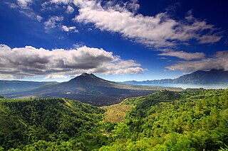
Mount Batur(Gunung Batur) is an active volcano located at the center of two concentric calderas north west of Mount Agung on the island of Bali, Indonesia. The south east side of the larger 10×13 km caldera contains a caldera lake. The inner 7.5-kilometer-wide caldera, which was formed during emplacement of the Bali ignimbrite, has been dated at about 23,670 and 28,500 years ago.

Mount Akagi is a mountain in Gunma Prefecture, Japan.

Mount Emmons is a post-caldera stratovolcano within the Emmons Lake caldera on the Alaska Peninsula within the Lake and Peninsula Borough, Alaska, United States.

Mount Okmok is the highest point on the rim of Okmok Caldera on the northeastern part of Umnak Island in the eastern Aleutian Islands of Alaska. This 9.3 kilometers (5.8 mi) wide circular caldera truncates the top of a large shield volcano. The volcano is currently rated by the Alaska Volcano Observatory as Aviation Alert Level Green and Volcanic-alert Level Normal.

Semisopochnoi Island or Unyak Island is part of the Rat Islands group in the western Aleutian Islands of Alaska. The island is uninhabited and provides an important nesting area for maritime birds. The island is of volcanic origin, containing several volcanoes including Mount Cerberus. It has a land area of 85.558 square miles, measuring 11 miles (18 km) in length and 12 miles (20 km) in width.

Mount Longonot is a stratovolcano located southeast of Lake Naivasha in the Great Rift Valley of Kenya, Africa. It is thought to have last erupted in the 1860s. Its name is derived from the Maasai word Oloonong'ot, meaning "mountains of many spurs" or "steep ridges".

A somma volcano is a volcanic caldera that has been partially filled by a new central cone. The name comes from Mount Somma, a stratovolcano in southern Italy with a summit caldera in which the upper cone of Mount Vesuvius has grown.

Wizard Island is a volcanic cinder cone which forms an island at the west end of Crater Lake in Crater Lake National Park, Oregon. The top of the island reaches 6,933 feet (2,113 m) above sea level, about 755 feet (230 m) above the average surface of the lake.

A complex volcano, also called a compound volcano, is mixed landform consisting of related volcanic centers and their associated lava flows and pyroclastic rock. They may form due to changes in eruptive habit or in the location of the principal vent area on a particular volcano. Stratovolcanoes can also form a large caldera that gets filled in by a lava dome, or else multiple small cinder cones, lava domes and craters may develop on the caldera's rim.
Segara Anak is a crater lake in the caldera that formed during the explosive volcanic eruption of Mount Samalas in 1257. The caldera is next to Mount Rinjani on Lombok Island in Indonesia. "Segara Anak" means "child of the sea" and refers to the blue lake's resemblance to the sea. The volcanic cone Gunung Barujari is at the eastern end of the lake and is responsible for its crescent shape. The lake temperature is 20–22 °C (68–72 °F), which is 5-7 °C higher than normal for a lake at its altitude. Hot magma below the lake is responsible for this anomaly. Gas bubbles escape from the lake floor, helping the lake to have a pH of 7-8.

Mount Macolod also called Mount Maculot is a mountain located in the town of Cuenca in Batangas province, in the Philippines. This mountain is popular among mountain climbers and campers; it is the major tourist attraction of the municipality. Every year on Holy Week, thousands of pilgrims from nearby towns and provinces climb the mountain as a form of penance. The mountain is sacred to both Christian and Anitist adherents.

The Mount Edziza volcanic complex is a large and potentially active north-south trending complex volcano in Stikine Country, northwestern British Columbia, Canada, located 38 kilometres (24 mi) southeast of the small community of Telegraph Creek. It occupies the southeastern portion of the Tahltan Highland, an upland area of plateau and lower mountain ranges, lying east of the Boundary Ranges and south of the Inklin River, which is the east fork of the Taku River. As a volcanic complex, it consists of many types of volcanoes, including shield volcanoes, calderas, lava domes, stratovolcanoes, and cinder cones.

Akan Volcanic Complex is a volcanic group of volcanoes that grew out of the Akan caldera. It is located within Akan National Park, about 50 km Northwest of Kushiro in eastern Hokkaidō, Japan.

Mount Hakone is a complex volcano in Kanagawa Prefecture, Japan that is truncated by two overlapping calderas, the largest of which is 10 × 11 km wide. The calderas were formed as a result of two major explosive eruptions about 180,000 and 49,000–60,000 years ago. Lake Ashi lies between the southwestern caldera wall and a half dozen post-caldera lava domes that arose along a southwest–northeastern trend cutting through the center of the calderas. Dome growth occurred progressively to the south, and the largest and youngest of them, Kami-yama, forms the high point of Hakone. The calderas are breached to the east by the Haya-kawa canyon. Mount Ashigara is a parasitic cone.

