Oak Bowery, Alabama

Last updated

Oak Bowery, Alabama
2019-10-28 Oak Bowery Cash Grocery - Oak Bowery, AL.jpg
The Oak Bowery Cash Grocery building in 2019.
USA Alabama location map.svg
Red pog.svg
Oak Bowery
Usa edcp location map.svg
Red pog.svg
Oak Bowery
Coordinates: 32°45′2″N85°26′11″W / 32.75056°N 85.43639°W / 32.75056; -85.43639
Country United States
State Alabama
County Chambers
Elevation
839 ft (256 m)
Time zone UTC-6 (Central (CST))
  Summer (DST) UTC-5 (CDT)
ZIP code
36862
Area code 334

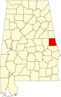
Oak Bowery is an unincorporated community in southern Chambers County, Alabama, United States. It lies along U.S. Route 431, north of Auburn.

Contents

Demographics

Historical population
CensusPop.Note
1880 120
U.S. Decennial Census [1]

History

Oak Bowery was first settled in 1828 by South Carolinians and was originally named Woodlawn. A Methodist camp meeting ground named Oak Bowery was established there soon after settlement, and the community adopted that name around 1835. In 1837, the Oak Bowery Female College was established, and in 1850 the East Alabama Masonic College located there. The community grew rapidly in the 1830s and 1840s, but a change in the planned routing of the Montgomery and West Point Railroad from Oak Bowery to a more southerly route ended the community's growth. Oak Bowery is today a small community of only a few residences and a church.

Notable people

Bibliography

Related Research Articles

<span class="mw-page-title-main">Lee County, Alabama</span> County in Alabama, United States

Lee County is a county located in east central Alabama. As of the 2020 census the population was 174,241. The county seat is Opelika, and the largest city is Auburn. The county was established in 1866 and is named for General Robert E. Lee (1807–1870), who served as General in Chief of the Armies of the Confederate States in 1865. Lee County comprises the Auburn-Opelika, AL Metropolitan Statistical Area, which is included in the Columbus-Auburn-Opelika, GA-AL Combined Statistical Area.

<span class="mw-page-title-main">Wilcox County, Alabama</span> County in Alabama, United States

Wilcox County is a county of the U.S. state of Alabama. As of the 2020 census, the population was 10,600. Its county seat is Camden.

<span class="mw-page-title-main">Selma, Alabama</span> City in Dallas County, Alabama, United States

Selma is a city in and the county seat of Dallas County, in the Black Belt region of south central Alabama and extending to the west. Located on the banks of the Alabama River, the city has a population of 17,971 as of the 2020 census. About 80% of the population is African-American.

<span class="mw-page-title-main">Brewton, Alabama</span> City in and county seat of Escambia County, Alabama

Brewton is a city in and the county seat of Escambia County, Alabama, United States. As of the 2020 census, the population was 5,276. Brewton is located in south central Alabama, just north of the Florida Panhandle.

<span class="mw-page-title-main">Auburn, Alabama</span> City in Alabama, United States

Auburn is a city in Lee County, Alabama, United States. It is the largest city in eastern Alabama. The population was 76,143 at the 2020 census. It is a principal city of the Auburn-Opelika Metropolitan Area. The Auburn-Opelika, AL MSA with a 2020 population of 193,773, along with the Columbus, GA-AL MSA and Tuskegee, Alabama, comprises the greater Columbus-Auburn-Opelika, GA-AL CSA, a region home to 563,967 residents as of 2020.

<span class="mw-page-title-main">Loachapoka, Alabama</span> Town in Alabama, United States

Loachapoka is a town in Lee County, Alabama, United States. It is located less than 1/2 mile west of Auburn and approximately 5 miles (8 km) west of Auburn University, in west-central Lee County. The population was 180 as of the 2010 Census. It is part of the Auburn metropolitan area.

<span class="mw-page-title-main">Opelika, Alabama</span> City in Alabama, United States

Opelika is a city in and the county seat of Lee County in the east-central part of the U.S. state of Alabama. It is a principal city of the Auburn-Opelika Metropolitan Area. As of the 2020 census, the population of Opelika is 30,995, an increase of 17.1 percent from the 2010 Census where the population was 26,477. The Auburn-Opelika, AL MSA with a population of 150,933, along with the Columbus, Georgia metropolitan area, comprises the Greater Columbus combined statistical area, a region home to 501,649 residents.

<span class="mw-page-title-main">Beauregard, Alabama</span> Unincorporated community in Alabama, United States

Beauregard is an unincorporated community located in central Lee County, Alabama, United States. It is located east of Auburn and south of Opelika.

<span class="mw-page-title-main">Beulah, Alabama</span> Unincorporated community in Alabama, United States

Beulah is an unincorporated community in the northeast corner of Lee County, Alabama, United States, just south of Valley. It is part of the Columbus, Georgia-Alabama Metropolitan Area. It is bounded by Chambers County on the north, the Chattahoochee River on the east, and the Halawaka Embayment of Lake Harding on the south.

Gold Hill, also known as Goldhill, Gold Mine, or Gold Ridge, is an unincorporated community north-centrally located in Lee County, Alabama, United States, just a few hundred feet south of the Chambers County line. It is part of the Columbus, Georgia-Alabama Metropolitan Area. Today, Gold Hill lies mostly in the corporate limits of Auburn.

<span class="mw-page-title-main">Salem, Alabama</span> Unincorporated community in Alabama, United States

Salem is an unincorporated community east-centrally located in Lee County, Alabama, United States. It lies along U.S. Routes 280 and 431 between Opelika and Phenix City. It is part of the Auburn Metropolitan Area.

<span class="mw-page-title-main">Treaty of Cusseta</span> 1832 treaty between the United States and Creek

The Treaty of Cusseta was a treaty between the government of the United States and the Creek Nation signed March 24, 1832. The treaty ceded all Creek claims east of the Mississippi River to the United States.

John William Jones was an American politician, planter, educator and physician. Born in Maryland and raised in Kentucky, Jones served one term in the United States Congress representing Georgia's 3rd congressional district, before resuming his careers as a planter and physician in Alabama as well as helped found two female seminaries before returning to Georgia. During the American Civil War, Jones accepted a commission as a surgeon in the Confederate States Army, and postwar taught medicine in Atlanta.

<span class="mw-page-title-main">Glenville, Alabama</span> Unincorporated community in Alabama, United States

Glenville is an unincorporated community in Russell County, Alabama, United States which used to be in Barbour County. During the Civil War, Company "H" of the 15th Regiment Alabama Infantry was raised from Barbour and Dale counties and called the "Glenville Guards". The Glennville Historic District, containing the antebellum core of the community, is a historic district listed on the National Register of Historic Places in 1979.

<span class="mw-page-title-main">Verbena, Alabama</span> Unincorporated community in Alabama, United States

Verbena, also known as Summerfield, is an unincorporated community in southeastern Chilton County, Alabama, United States. Named for the indigenous flower, Verbena developed into a popular resort location for the more affluent citizenry of Montgomery, the state's capital, during the yellow fever outbreaks of the late 19th and early 20th centuries. Many stately homes, some of which have undergone recent renovation and restoration, line the streets of the town as a reminder of this historic past.

<span class="mw-page-title-main">Gerald–Dowdell House</span> Historic house in Alabama, United States

The Gerald–Dowdell House, in Montgomery, Alabama, was built c.1854. It was listed on the National Register of Historic Places in 1980.

Yelvington is a small unincorporated community in the U.S. state of Kentucky, located approximately 12 miles east of Owensboro along U.S. Route 60 east and near the Daviess-Hancock county line.

<span class="mw-page-title-main">Smiths Station High School</span> Public school in Smiths Station, Alabama, United States

Smiths Station High School is a high school in Smiths Station, Alabama, enrolling grades 9 to 12. The school enrolls about 1,382 students, and is one of four high schools in the Lee County School District along with Beauregard, Beulah, and Loachapoka High Schools.

<span class="mw-page-title-main">Beauregard High School</span> Public school in Beauregard, Alabama, United States

Beauregard High School is a high school in Beauregard, Alabama, enrolling grades 9-12. The school enrolls 584 students, and is one of four high schools in the Lee County School District along with Beulah, Loachapoka, and Smiths Station High Schools. Beauregard High School is named for Confederate Army general P.G.T. Beauregard.

References

  1. "U.S. Decennial Census". Census.gov. Archived from the original on May 7, 2015. Retrieved June 6, 2013.
  2. 1 2 3 Miriam Ann Kirkwood Syler, "Oak Bowery, Historic Community", Lee County and Her Forebears. (Montgomery, Ala.: Herff Jones, 1983), 19.
  3. Miriam Ann Kirkwood Syler, "Oak Bowery, Historic Community", Lee County and Her Forebears, 20.
  4. "JONES, John William", retrieved February 7, 2009.
  5. Miriam Ann Kirkwood Syler, "Oak Bowery, Historic Community", Lee County and Her Forebears, 18.