Oak Bowery, Alabama | |
|---|---|
 The Oak Bowery Cash Grocery building in 2019. | |
 Oak Bowery  Oak Bowery | |
| Coordinates: 32°45′2″N85°26′11″W / 32.75056°N 85.43639°W | |
| Country | United States |
| State | Alabama |
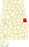
| County | Chambers |
| Elevation | 839 ft (256 m) |
| Time zone | UTC-6 (Central (CST)) |
| • Summer (DST) | UTC-5 (CDT) |
| ZIP code | 36862 |
| Area code | 334 |
Oak Bowery is an unincorporated community in southern Chambers County, Alabama, United States. It lies along U.S. Route 431, north of Auburn.