Related Research Articles

In geography, an oasis is a fertile land in a desert or semi-desert environment. Oases also provide habitats for animals and plants.
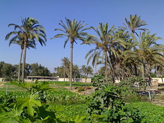
Awjila is an oasis town in the Al Wahat District in the Cyrenaica region of northeastern Libya. Since classical times it has been known as a place where high quality dates are farmed. From the Arab conquest in the 7th century, Islam has played an important role in the community. The oasis is located on the east-west caravan route between Egypt and Tripoli, and on the north-south route between Benghazi and the Sahel between Lake Chad and Darfur, and in the past was an important trading center. It is the place after which the Awjila language, an Eastern Berber language, is named. The people cultivate small gardens using water from deep wells. Recently, the oil industry has become an increasingly important source of employment.
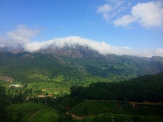
The Western Ghats or the Western Mountain range is a mountain range that covers an area of 160,000 km2 (62,000 sq mi) in a stretch of 1,600 km (990 mi) parallel to the western coast of the Indian peninsula, traversing the states of Gujarat, Maharashtra, Goa, Karnataka, Kerala and Tamil Nadu. It is a UNESCO World Heritage Site and is one of the eight biodiversity hotspots in the world. It is sometimes called the Great Escarpment of India. It contains a very large proportion of the country's flora and fauna, many of which are endemic to this region. According to UNESCO, the Western Ghats are older than the Himalayas. They influence Indian monsoon weather patterns by intercepting the rain-laden monsoon winds that sweep in from the south-west during late summer. The range runs north to south along the western edge of the Deccan Plateau and separates the plateau from a narrow coastal plain called Konkan along the Arabian Sea. A total of 39 areas in the Western Ghats, including national parks, wildlife sanctuaries and reserve forests, were designated as world heritage sites in 2012 – twenty in Kerala, ten in Karnataka, six in Tamil Nadu and four in Maharashtra.
Ubari or Awbari is a Tuareg Berber-speaking oasis town and the capital of the Wadi al Hayaa District, in the Fezzan region of southwestern Libya. It is in the Idehan Ubari, a Libyan section of the Sahara Desert. It was the capital of the former baladiyah (district) called Awbari, in the southwest of the country.

Murzuk, Murzuq, Murzug or Merzug is an oasis town and the capital of the Murzuq District in the Fezzan region of southwest Libya. It lies on the northern edge of the Murzuq Desert, an extremely arid region of ergs or great sand dunes which is part of the greater Sahara Desert.

The Acacus Mountains or Tadrart Akakus form a mountain range in the desert of the Ghat District in western Libya, part of the Sahara. They are situated east of the city of Ghat, Libya, and stretch north from the border with Algeria, about 100 kilometres (62 mi). The area has a particularly rich array of prehistoric rock art.

Chandoli National Park is a national park spread over Satara, Kolhapur and Sangli Districts, Maharashtra state, India, established in May 2004. Earlier it was a Wildlife Sanctuary declared in 1985. Chandoli Park is notable as the southern portion of the Sahyadri Tiger Reserve, with Koyna Wildlife Sanctuary forming the northern part of the reserve

Anamudi Shola National Park is a protected area located along the Western Ghats of Idukki district in Kerala state, India. It is composed of Mannavan shola, Idivara shola and Pullardi shola, covering a total area of around 7.5 km². Draft notification of this new park was released on 21 November 2003.

The wildlife of Libya is spread over the Mediterranean coastline and encompasses large areas of the Saharan desert. The protection of wildlife is provided through appropriate legislation in seven national parks, five reserves, 24 protected areas, two wetlands under Ramsar Convention, and also in other areas. Apart from these, there are also five UNESCO World Heritage Sites related to culture. The most important national parks are the El-Kouf National Park and Karabolli National Park. The well known nature reserves are the Benghazi Reserve and the Zellaf Reserve. The wildlife species recorded in the country are 87 mammals and 338 species of birds.
National parks of Israel are declared historic sites or nature reserves, which are mostly operated and maintained by the National Nature and Parks Authority. As of 2015, Israel maintains 81 national parks and more than 400 nature reserves, many of them in the occupied West Bank, that protect 2,500 species of indigenous wild plants, 32 species of fish, 530 species of birds and 100 species of mammals.

Grass Hills National Park is a protected area in the Western Ghats, India, and a part of the Anamalai Tiger Reserve, forming its boundary with Eravikulam National Park in neighbouring Kerala state. It is not an actual National Park. It spreads over 65,000 hectares. The landscape is a combination of peaks and high plateaus above 2,000 metres (6,600 ft) MSL composed of montane shola-grassland ecosystem that is unique to the higher ranges of the Western Ghats of Kerala and Tamil Nadu.
Dandeli National Park is a protected area in the Western Ghats, India.
The Fezzan campaign was a military campaign conducted by the National Liberation Army to take control of southwestern Libya during the Libyan Civil War. During April to June 2011, anti-Gaddafi forces gained control of most of the eastern part of the southern desert region during the Cyrenaican desert campaign. In July, Qatrun changed to anti-Gaddafi control on 17 July and back to pro-Gaddafi control on 23 July. In late August, anti- and pro-Gaddafi forces struggled for control of Sabha.
Protected areas of Libya include any geographical area protected for a specific use.
Rajma National Park is a national park in Libya. It is a wetlands and protected area within the Jabal al Gharbi District of Libya, south of Tripoli and Murqub. This district is landlocked, meaning Rajma does not have the coastal diversity found in some areas of the country. This area, like Abughlian, is known for its mountains and harsh desert areas. Lizards, snakes, and rodents are commonplace within Rajma. Desert mammals including hyenas and wildcats also reside in this area. Rajma is also known for the abundance of date palms as well as fig and olive trees.
Ain Zayanah is a protected area of Libya. It has an area of 500 hectares, and covers the Ayn Zayanah lagoon and a portion of the coast 15 km northeast of Benghazi. It is a component of the Benghazi Nature Reserve.
The Al Jaghbub Oasis is a protected area in northeastern Libya lying close to the border with Egypt. It adjoins the desert village of Jaghbub which is inhabited by Berbers with a population of about 400.

The Western Desert of Egypt is an area of the Sahara that lies west of the river Nile, up to the Libyan border, and south from the Mediterranean Sea to the border with Sudan. It is named in contrast to the Eastern Desert which extends east from the Nile to the Red Sea. The Western Desert is mostly rocky desert, though an area of sandy desert, known as the Great Sand Sea, lies to the west against the Libyan border. The desert covers an area of 680,650 km2 (262,800 sq mi) which is two-thirds of the land area of the country. Its highest elevation is 1,000 m (3,300 ft) in the Gilf Kebir plateau to the far south-west of the country, on the Egypt-Sudan-Libya border. The Western Desert is barren and uninhabited save for a chain of oases which extend in an arc from Siwa, in the north-west, to Kharga in the south. It has been the scene of conflict in modern times, particularly during the Second World War.

The Fortress of Ghat is a fort on top of the hill of Koukemen in Ghat, Libya. It was started by the Military of the Ottoman Empire and rebuilt in 1930s after partial destruction caused by the Italian campaign against Libya.
The Ubari conflict is an ongoing territorial dispute between the Tuareg and Tubu tribes over control of the town of Ubari, located near the oasis city of Sabha, Libya.
References
- ↑ "Parks, Reserves, and Other Protected Areas in the Libyan Arab Jamahiriya". Parks.it. Retrieved 26 March 2013.
- ↑ "Ghat Germa of the Garamantes". www.temehu.com. Retrieved 2021-01-08.
- ↑ "Ghāt | oasis, Libya". Encyclopedia Britannica. Retrieved 2021-01-08.
| | This Libya location article is a stub. You can help Wikipedia by expanding it. |
| | This Africa protected areas related article is a stub. You can help Wikipedia by expanding it. |