Related Research Articles
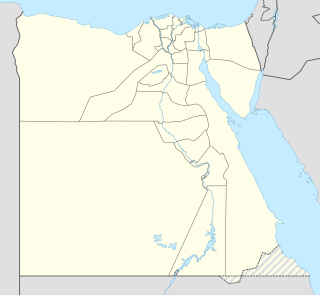
The geography of Egypt relates to two regions: North Africa and Southwest Asia.
The Qattara Depression is a depression in northwestern Egypt, specifically in the Matruh Governorate. The depression is part of the Western Desert of Egypt. The Qattara Depression lies below sea level, and its bottom is covered with salt pans, sand dunes, and salt marshes. The depression extends between the latitudes of 28°35' and 30°25' north and the longitudes of 26°20' and 29°02' east.
Awjila is an oasis town in the Al Wahat District in the Cyrenaica region of northeastern Libya. Since classical times it has been known as a place where high quality dates are farmed. From the Arab conquest in the 7th century, Islam has played an important role in the community. The oasis is located on the east-west caravan route between Egypt and Tripoli, and on the north-south route between Benghazi and the Sahel between Lake Chad and Darfur, and in the past was an important trading center. It is the place after which the Awjila language, an Eastern Berber language, is named. The people cultivate small gardens using water from deep wells. Recently, the oil industry has become an increasingly important source of employment.

The Senussi or Sanusi are a Muslim political-religious tariqa and clan in colonial Libya and the Sudan region founded in Mecca in 1837 by the Grand Senussi, the Algerian Muhammad ibn Ali as-Senussi. Senussi was concerned with what he saw as both the decline of Islamic thought and spirituality and the weakening of Muslim political integrity.

The Libyan Desert is a geographical region filling the north-eastern Sahara Desert, from eastern Libya to the Western Desert of Egypt and far northwestern Sudan. On medieval maps, its use predates today's Sahara, and parts of the Libyan Desert include the Sahara's most arid and least populated regions; this is chiefly what sets the Libyan Desert apart from the greater Sahara. The consequent absence of grazing, as well as virtually no waterholes or wells needed to sustain camel caravans, explains why no Trans-Saharan trade routes existed between Kharga close to the Nile, and Murzuk in the Libyan Fezzan. This obscurity saw the region overlooked by early European explorers, and it was not until the early 20th century and the advent of the motor car before the Libyan Desert started to be fully explored.

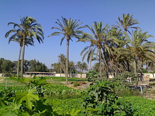
The Siwa Oasis is an urban oasis in Egypt between the Qattara Depression and the Great Sand Sea in the Western Desert, 50 km (30 mi) east of the Libyan border, and 560 km (348 mi) from Cairo. About 80 km (50 mi) in length and 20 km (12 mi) wide, Siwa Oasis is one of Egypt's most isolated settlements with about 33,000 people, mostly Berbers, who developed a unique and isolated desert culture and a language called Siwi; they are also fluent in the Egyptian dialect of Arabic which is called "Masry" meaning Egyptian.

ʿOmar al-Mukhṭār Muḥammad bin Farḥāṭ al-Manifī, called The Lion of the Desert, known among the colonial Italians as Matari of the Mnifa, was the leader of native resistance in Cyrenaica under the Senussids, against the Italian colonization of Libya. A teacher-turned-general, Omar was also a prominent figure of the Senussi movement, and he is considered the national hero of Libya and a symbol of resistance in the Arab and Islamic worlds. Beginning in 1911, he organised and, for nearly twenty years, led the Libyan resistance movement against the Italian colonial empire during the Pacification of Libya. After many attempts, the Italian Armed Forces managed to capture Al-Mukhtar near Solonta and hanged him in 1931.

El-Wahat el-Bahariya or el-Bahariya ; is a depression and a naturally rich oasis in the Western Desert of Egypt. It is approximately 370 km away from Cairo. The roughly oval valley extends from northeast to southwest, has a length of 94 km, a maximum width of 42 km and covers an area of about 2000 km².

Kufra is a basin and oasis group in the Kufra District of southeastern Cyrenaica in Libya. At the end of nineteenth century Kufra became the centre and holy place of the Senussi order. It also played a minor role in the Western Desert Campaign of World War II.

Egyptians speak a continuum of dialects. The predominant dialect in Egypt is Egyptian Colloquial Arabic or Masri/Masry, which is the vernacular language. Literary Arabic is the official language and the most widely written; additionally, it is the liturgical language of Islam, the majority religion and state religion of Egypt. The Coptic language is used primarily by Egyptian Copts and it is the liturgical language of Coptic Christianity.

Jaghbub is a remote desert village in the Al Jaghbub Oasis in the eastern Libyan Desert. It is actually closer to the Egyptian town of Siwa than to any Libyan town of note. And like Siwa, its population is Berber. The oasis is located in Butnan District and is the administrative seat of the Jaghbub Basic People's Congress. Supported by reservoirs of underground water and date production, the town is best known for its hard-won self-sufficiency. Idris of Libya was born in Jaghbub on 12 March 1890.

The Senussi campaign took place in North Africa from November 1915 to February 1917, during the First World War. The campaign was fought by the Kingdom of Italy and the British Empire against the Senussi, a religious order in Libya and Egypt. The Senussi were courted by the Ottoman Empire and the German Empire. In the summer of 1915, the Ottomans persuaded the Grand Senussi Ahmed Sharif as-Senussi to declare jihad, attack British-occupied Egypt from the west and to encourage insurrection in Egypt, to divert British forces from an Ottoman Raid on the Suez Canal from Palestine.

The wildlife of Egypt is composed of the flora and fauna of this country in northeastern Africa and southwestern Asia, and is substantial and varied. Apart from the fertile Nile Valley, which bisects the country from south to north, the majority of Egypt's landscape is desert, with a few scattered oases. It has long coastlines on the Mediterranean Sea, the Gulf of Suez, the Gulf of Aqaba and the Red Sea. Each geographic region has a diversity of plants and animals each adapted to its own particular habitat.
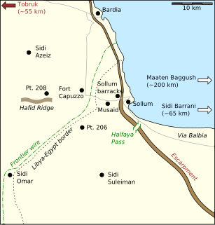
The Frontier Wire was a 271 km (168 mi) obstacle in Italian Libya, along the length of the border of British-held Egypt, running from El Ramleh, in the Gulf of Sollum south to Jaghbub parallel to the 25th meridian east, the Libya–Egypt and Libya–Sudan borders. The frontier wire, and its line of covering forts, was built by the Italians during the Second Italo-Senussi War (1923–1931), as a defensive system to contain the Senussi population, who crossed from Egypt during their resistance against Italian colonisers.

Conflicts took place in North Africa during World War I (1914–1918) between the Central Powers and the Entente and its allies. The Senussi of Libya sided with the Ottoman Empire and the German Empire against the British Empire and the Kingdom of Italy. On 14 November 1914, the Ottoman Sultan proclaimed a jihad and sought to create a diversion to draw British troops from the Sinai and Palestine Campaign. Italy wished to preserve its gains from the Italo-Turkish War. The Senussi Campaign took place in North Africa from 23 November 1915 to February 1917.

The Action of Agagia took place east of Sidi Barrani in Egypt on 26 February 1916, during the Senussi Campaign between German and Ottoman-instigated Senussi forces and the British army in Egypt. On 11 December 1915, a British column had been attacked at Duwwar Hussein along the Matruh–Sollum track. In the Affair of Wadi Senba, the Senussi were defeated and two days later a Senussi attack at Wadi Hasheifiat was repulsed. The British returned to Matruh until 25 December, then surprised the Senussi at the Affair of Wadi Majid but the Senussi got away. At the Affair of Halazin on 23 January, the Senussi were defeated and again slipped away.

The Siege of Giarabub in Libya, was an engagement between Commonwealth and Italian forces, during the Western Desert Campaign of the Second World War. In the aftermath of Operazione E, the invasion of Egypt by the Italian 10th Army (9–16 September 1940), Operation Compass (9–16 December) by the Western Desert Force (WDF), the Battle of Sidi Barrani and the pursuit of the 10th Army into Cyrenaica (16 December 1940 – 9 February 1941) the fortified Italian position at the Al Jaghbub Oasis was besieged by parts of the 6th Australian Division.

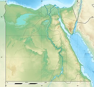
The Western Desert of Egypt is an area of the Sahara that lies west of the river Nile, up to the Libyan border, and south from the Mediterranean sea to the border with Sudan. It is named in contrast to the Eastern Desert which extends east from the Nile to Red Sea. The Western Desert is mostly rocky desert, though an area of sandy desert, known as the Great Sand Sea, lies to the west against the Libyan border. The desert covers an area of 680,650 km2 (262,800 sq mi) which is two-thirds of the land area of the country. Its highest elevation is 1,000 m (3,300 ft) in the Gilf Kebir plateau to the far south-west of the country, on the Egypt-Sudan-Libya border. The Western Desert is barren and uninhabited save for a chain of oases which extend in an arc from Siwa, in the north-west, to Kharga in the south. It has been the scene of conflict in modern times, particularly during the Second World War.

The Egypt–Libya border is 1,115 km in length and runs from the Mediterranean Sea in the north to the tripoint with Sudan in the south.

The Saharan halophytics ecoregion covers a series of low-lying evaporite depressions and wetlands spread across North Africa. The depressions are characteristically saline, variously chotts or sabkhas. The plants of the areas are highly specialized to survive in the harsh environment, with many being xerophytess (drought-tolerant) and halophytes (salt-tolerant). The biodiversity of the areas has been relatively protected by their isolation, and unsuitability of alkaline soil for farming.
References
- 1 2 Ham, Anthony (2007). Libya . Lonely Planet. pp. 154–155. ISBN 978-1-74059-493-6.
- ↑ Elevation data by NASA's SRTM
- ↑ Hassan, Safiya M. (2013). Sequence Stratigraphy of the Lower Miocene Moghra Formation in the Qattara Depression, North Western Desert, Egypt. Springer Science & Business Media. p. 9. ISBN 978-3-319-00330-6.
- ↑ Hallett, Don (2002). Petroleum Geology of Libya. Elsevier. p. 263. ISBN 978-0-08-053869-3.
- ↑ Philip's (1994). Atlas of the World. Reed International. pp. 96–97. ISBN 0-540-05831-9.
- ↑ "Parks, Reserves, and Other Protected Areas in the Libyan Arab Jamahiriya". Parks.it. Retrieved 6 February 2016.
- ↑ Carp, Erik (1980). Directory of Wetlands of International Importance in the Western Palearctic. IUCN. p. 253. ISBN 978-2-88032-300-4.